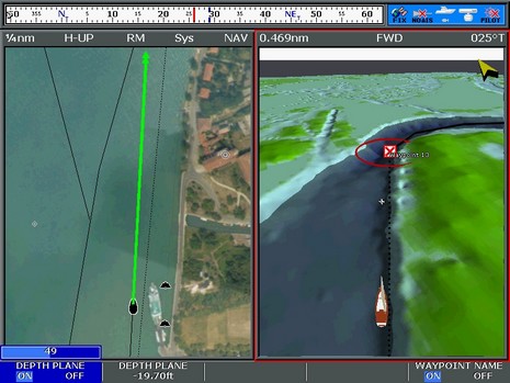
The good news is that more Furuno NavNet 3D MFDs are getting delivered and installed; the bad news is that some of the first users aren’t happy with the charts, neither the rasters nor the vectors. For instance, the two empty MFD12 holes we saw a while back are finally filled, but now the owner—Hull Truth poster “PSW”—is wishing he could use Navionics cards in his MFD12s, as are fellow posters “srmote” and “snowpup”. And I know that our own frequent poster Russ was not pleased with his first look at the charts on his MFD8. My own NN3D experience off Cape Cod did not leave me nearly as negative, but I did note some weaknesses. It helps that I like raster charts and am used to plotting on them, but I didn’t think they worked very well on the 8” display, as suggested in the screen above. Some other levels of zoom/chart scale looked better, and some worse. 3D perspective can put more info on the screen—and fast panning/zooming make it all more tolerable—but there’s just no getting around the fact that you’re looking at a large paper chart through an 8” window. The rasters looked fine to me on the 15” display that was also on the test boat, and I’d guess they’d work OK at 12” (but the Hull Truth gang don’t seem to think so).
After I’d written my first impressions of the new E-Series 4.29 software and the Platinum+ charts it supports, I learned that I hadn’t done the “real” version of the recommended factory/master reset. You see, though Raymarine’s own FAQ is unclear about it, a reset done by powering up while holding down the leftmost soft key is apparently different, and deeper, than the one I’d done from the System Setup menu. I know for sure that this is true, as after a “real” reset yesterday, some of the problems I’d seen went away. For instance, I can pull up the System Diagnostics SeaTalkNG sub-menus now without causing a reset, though the device list there remains strangely empty (the new manual says it’s “for diagnostic use by authorized dealers” anyway). Much more important is how the test E seems be performing even quicker and looking better than what I’d noticed the first time around.
I’ve been bench testing Raymarine’s E-Series V4 software update (aka 4.29) for a while now, mostly with a variety of new Navionics Platinum+ cards I borrowed. If you’ve read the comments to that V4 post, you’ll know that some upgraders have had to revert to 3.31, and I’m not surprised. There’s lots of changes in 4.29, and even my relatively unstressed test E-120—just a bit of N2K input; nothing attached via standard SeaTalk, SThs, or NMEA 0183 right now—goes a little twitchy sometimes. Like suddenly the 3D rotary controls don’t work unless I do a reset. And it invariably resets when I try to query the new STng (N2K) diagnostic screen, no matter what’s on the backbone. Plus I’ve yet to see P+’s live tide/current icons or the now built-in Fish’N Chip bathy data, despite another 4.29 flash and master reset (apparently Raymarine and Navionics are working on that latter one). However, I’d certainly recommend updating; just be prepared to go back to 3.31 if needed, and be on the lookout for the update to the update surely in the works.
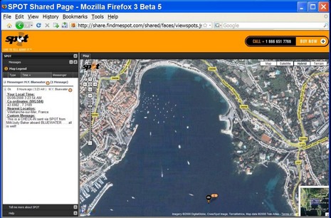
Panbo commenters don’t seem very interested in Spot sharing, but I think it’s a cool deal for long range cruisers like Milt and Judy Baker, not to mention working mariners like Capt. Richard Rodriguez. Note how the Baker’s custom message is displayed next to their anchorage on the French Riviera, above and bigger here . And today I notice that Mad Mariner apparently has arranged with West Marine for an extra special Spot deal ($132), and that West customer product reviews are all five star. Even the SSCA offshore guys are taking a cautious look at it
The old days may be something like the new days, but not entirely! Check out the full screen of this NOAA raster/Google maps mashup; it’s the work of Just Magic, aka GeoGarage, and is not only way slicker than what we saw two years back, but is one of the neater Camden Harbor images I’ve ever seen. Of course it helps that Google has high res photo maps for my area now, and they register so darn perfectly with the raster chart. Try it live yourself, fool with those sliders upper right, search out your own harbor, and perhaps join me with big tip of the propeller beanie to those crazy Frenchmen in their GeoGarage.
Well, hot damn! How about a full featured PC planning product that includes maps for 10,000 U.S. lakes, all on a $20 DVD? I just heard about it this morning, but my first impression of Navionics HotMaps Explorer is “who wouldn’t?” Well, I suppose if you never, ever go out on lakes, but I do and was pleased to see that the coverage list includes a lot of Maine lakes. Now my favorite, Lake Megunticook, is not covered by any digital map maker, I don’t think, though I keep hoping that Navionics will do one of its high definition surveys there and let me see at least some of their techniques. By the way, the download of one HD lake map is included in HotMaps Explorer.
So today I got a 512 Meg SD card and thus can now take screenshots on the Northstar M121. One I wanted to show you is this nifty “About” screen which includes the color coding for most of the unit’s possible input/output wiring, and which turned out to be particularly timely because C-Map just initiated a recall for certain Max chart cards if used with certain plotter software. If and when you go the C-Map Recall page, what you’ll need to know is the “cartridge code” shown in “Slot 2” above and the plotter’s software version, shown upper left. In fact, the recall only involves Max cards dated prior to October, 2006, and only certain plotters, mostly early versions of Si-Tex, Interphase, Standard Horizon, Cobra, Furuno, and European machines (that all run Max cartography).
One of my happiest discoveries at MIBS was not a new product or feature, but simply a matter of pricing and packaging. Maptech has radically reduced the hassle and cost of owning its international raster charts, really big time.
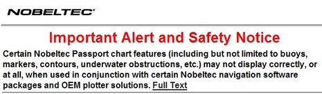
Yike. It seems that Nobeltec has guaranteed its support staff a busy holiday season by issuing the ominous sounding alert above along with update 9.3.2240 to its VNS and Admiral charting software. The exact chart regions/software combinations that have the problem are listed in the bulletin, and include the Northstar 972 but not the Simrad GB60. The good news for anyone who has trouble with the update is that Nobeltec recently extended its support lines to 13 hours a day during the week and 10 hours a day on weekends. The bad news for some is that with this update Nobeltec removes the ability to import S57 vector charts—for most people that means the free ENCs offered by NOAA—and even disables those already imported.
Sort of like repairing or upgrading old instruments, you could also spend some winter off water time getting your waypoints and routes in order. C-Map has put together a nice tip sheet on how you might do that using their chart cards along with the nifty PC Planner product that lets you bring home plotter data and work with it and your C-Map charts on your computer. (To get the PDF, click on the orange card reader here.) You may not be up for making “chart art”, like above, but doesn’t it make sense to sort through the waypoints, tracks, and routes you accumulated last season?