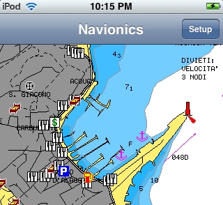
Congratulations to Navionics for winning the DAME Design Award (marine-related software category) with Navionics Mobile. And it turns out there’s going to be more to this product than I first understood. In addition to large portfolios of vector charts to run in iNavX, Navionics will also offer a free viewer and inexpensive small area charts. In fact there’s already a preview of Navionics Viewer in the Apple Apps Store. It includes impressively detailed sample cartography of the area around Genoa, Italy, which is how I took the screen shot above, full size here (but it still takes Google Maps to see the hotel pool I once swam in ;-). Zooming and panning are reasonably quick on my iPod Touch, and I look forward to seeing the finished app. There’s no end to the iPhone effect.
When Furuno NavNet 3D was first teased, I didn’t get the “native 3D” part. How could a “true 3D environment” be based on decidedly 2D raster and ENC charts? But I get it now. Whatever you see in NN3D’s conventional top-down 2D view—including routes, AIS targets, radar overlay, etc.—you can also see in 3D. It’s the same data, just tilted and shaded, and easy to fly around in. Which feels different—more “native”, more “true”—than any other 3D navigation I’ve tried before, and much more useful. So I think it’s great that Navionics has apparently developed a way to bring this sort of continuous-zooming, full-detail 3D to a variety of platforms. It’s called Navionics TurboView and I saw the preview above, and bigger here, at FLIBS.
Everywhere I wandered at FLIBS, there was someone fooling with, or showing off, their iPhone. And that includes me, sort of, as I’m now the very enthusiastic owner of an iPod Touch. I’ve always stubbornly resisted the Mac/iPod/Jobs fervor/hype—in fact, this is my first ever Apple product—but, wow, today my propeller beanie is tipped toward Cupertino. Plenty of smart marine developers have also noticed the slick capabilities of the iPhone/Touch apps platform. Being demoed above, for instance, is MySiMON, an extension of Palladium Technology’s megayacht monitoring and control system. The link will give you a sense of how useful this could be to a Touch-toting crew within a yacht’s WiFi network, but picture too an owner able to network with SiMON via iPhone and his yacht’s satellite communications system. So many possibilities…
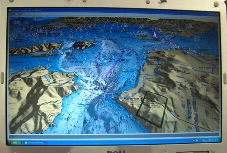
That strange graphic rendered on a laptop in a car trunk stuffed with cold weather clothing represents a terrific experience I had yesterday, and a wicked lot of work. Compare the graphic—which is actually hundreds of thousands of GPS/depth data points—to Lake Megunticook. After a few months and a lot of post processing that data will become a Navionics HD HotMap available on a chart card or for use with easy-on-the-wallet HotMaps Explorer. I don’t yet know how much Navionics will let me write about their specific data collection gear and techniques (Yachting revealed a bit), but here’s what it looks like:
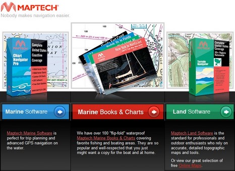
Above is the new home page at Maptech.com, and while it represents the end of the old Maptech, it sure doesn’t mark the end of the Maptech name. In fact, the blue “Marine Software” tab takes you to a new company called Maptech Navigation. It’s the creation of Peter Martin, who’s worked for Maptech, Chartkit, and as a professional mariner. Martin bought the rights to develop and market Maptech’s digital charts and software packages (except for The Capn, which found its own good home). Martin says his plan is basically “business as usual”…
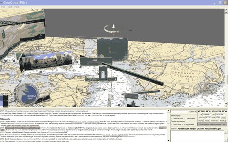
(Psssst!…back at work but need a little distraction, preferably for a good cause?) The screen shot above is worth seeing full size, but even then doesn’t do justice to the highly dynamic GeoCoastPilot beta program I’ve been entranced with for the last hour or so. The concept is an interactive 3D map that integrates official NOAA Coast Pilot textual information with vector and raster charts, bathy data, and panoramic photographs of key features. In this particular scene I clicked on the Portsmouth Harbor Channel Lighted Range link and the program lined up and highlighted a picture that might make it much easier to actually see the marks. When I then use the screen gizmo above the photo to tilt or turn the scene the photo changes if there are multiple shots available. There’s much more to it, as suggested by the choices at lower right, and for beta software, it seems to work pretty well. If you have a PC running XP or 2000, you go the GeoCoastPilot site and try it yourself, and you should!
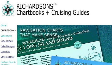
This week Maptech sold it paper chart and guide book division to Richardsons’ Publications, which was already producing similar products. In fact, a principal there was working at BBA/ChartKit when Maptech purchased it in 1997. “Things have come full circle.” A nice aspect to this deal is that most of the Maptech print staff will now work for Richardsons’. Sounds like the various Maptech chart books and guides will carry on nicely..
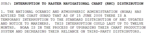
The U.S. Government has stopped distributing electronic updates to the official raster charts for up to 12 months? That doesn’t sound good. NOAA’s download site doesn’t mention a time frame for the “Interruption” but the U.S.C.G. internal bulletin shown in part above is more dire. (It’s published in full on Kurt Schwehr’s site, where you can also check out the Chart of the Future.) This is bad news for all of us who like using RNCs (Raster Navigation Charts) in the many charting programs that support them, not to mention Furuno, which decided to go with U.S. RNCs (and ENCs) in NavNet 3D and is already taking some heat for it. When NOAA decided to serve up RNCs free back in 2005, one of the big pluses was that they would be kept very current, and there were even little patch updates available. Besides, isn’t it depressing to any American that our government can’t even keep a relatively simple and inexpensive program like this going?
It’s wicked hot and sticky here, especially at this big computer, so what a fine time to receive a Panbot e-mail suitable as a guest entry! Richard Stephens—developer behind, and sometimes soggy user of, Memory-Map charting software—recently sailed aboard the Tripp 33TRPXPRS in the Bermuda Ocean Race and reports:
If you'll take a moment to read Ben's comments on Panbo, you'll understand the problem. There is data on the NOAA charts that is not on the NN3D raster chart view. There is a problem with the conversion from the Maptech format to TimeZero format.
Geez Louise! I may not have expressed myself well, but that’s not what I wrote about Furuno NavNet 3D chart issues last week. And the post above is just one of many that I think are way wide of the mark. According to some on Hull Truth the NN3D raster and vector charts for the U.S. are both useless, it was actually Navionics vectors that was shown at the boat show demos, the MFDs show less chart data than the Black Box because of video chip differences, etc. It’s mostly baloney, but Furuno USA has been paying attention to early user dissatisfaction with the vector charts. In fact, I got a call today from Camas with the news that Furuno will be selling U.S. NN3D vector charts based on Navionics data by early 2009. But let’s break that down: