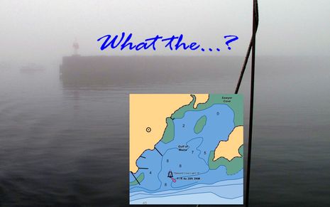
Yup, the first time you cruise into Sawyer Cove in often foggy Jonesport, Maine, you may be surprised to discover that there is a substantial steel and concrete breakwater extending from the fixed light almost all the way to the Eastern shore. That's because the structure still hasn't made it onto the official charts, or any chart I've seen, even though it was built over 20 years ago, and even though the NOAA ENC inset above was updated on 9/17/2010. I mentioned this when I first wrote about Sawyer Cove in August, but that entry was largely about how poorly any of the guides -- digital or paper, professionally written or crowd sourced -- covered the facilities available. Since then I've learned more about the breakwater situation, and it's depressing...
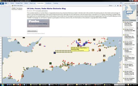
Back in April I enthused about the improved Guide Book section seen in the Coastal Explorer 2010 beta, soon to be official in CE 2011, but I didn't mention discovering all the UK and Euro data that's had been added using CE's own built-in Guidebook tool. I've played with the tool myself, and it's easy to create a POI with free form text, a link, and even photos. And it's easy to sync/cache all the Guidebook data stored on CE.net, like it is with ActiveCaptain, Atlantic Cruising Club, and other data sets (when your PC is online). But for some reason hardly anyone in the U.S., aside from the Pacific Northwest, has contributed Guidebook data. So how is it that England and nearby coasts are studded with all sorts of valuable port and marina Guidebook POIs -- and some more fanciful items, like that nice shout out to Panbo above? And what might it say about this whole crowd sourcing thing?
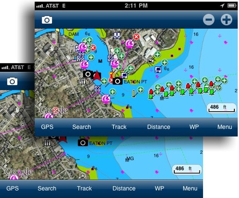
Big, big news in the world of user generated content (or UGC, or crowd sourcing, or whatever we decide to call it): Navionics Mobile 5, rolling out around the world as I write, supports UGC, big time, and it's central to the company's "Navionics Anytime, Anywhere" vision of the future. Those screen shots above -- which show the new "Community Layer" turned on and off -- are from a beta of US East 5.0 running on the Panbo test iPhone, but most all of that UGC work was done by Navionics founder and chief visionary Giuseppe Carnevali when he cruised up here in early September. It would be hard to overstate Giuseppe's enthusiasm about enabling interested Navionics users to share data of all sorts, some of which can be validated and added to the company's regular chart database for the benefit of all users...
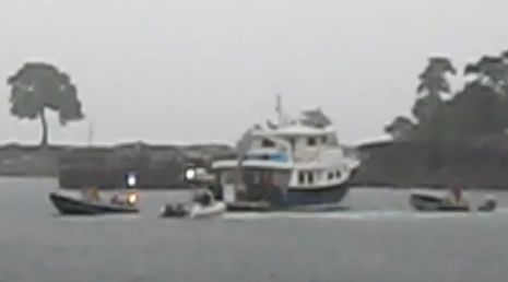
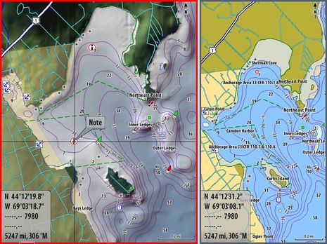
I'm generally quite reluctant to fault fellow boaters when things go wrong, because I've made about every mistake possible myself at some point, and probably will again. But what I hear about this scene, captured in part on YouTube, is a bit disturbing. That big beautiful trawler didn't actually drag onto the rocks around Northeast Point, but that's probably only because crews from from Wayfarer Marine, Yachting Solutions, and the Harbor Master's office worked hard to hold her off, in pouring rain and lots of wind. A local hero even managed to squeeze his way through a pilothouse window, figure out the complex starting procedure, hoist the anchor, and put the boat safely on a dock. But the owner, who showed up after the storm had passed, was apparently somewhat casual about what happened, though most boaters would know that a salvage claim was a possible road not taken by the rescuers, and...
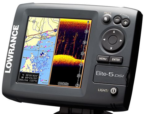
Last week Lowrance announced the Elite-5 DSI and some related fishfinder/plotters, and while they're unabashedly aimed at freshwater fishermen, there's at least two things of interest to others. DSI stands for DownScan Imaging, which seems to mean that Lowrance has isolated the high resolution down-looking portion of StructureScan into an even more inexpensive form. That means a transducer that can ping at 455 or 800 kHz, trading detail for depth and breadth. Aren't lots of non-fishing boaters -- like gunkholers and/or curious monkeys like me -- also interested in detailed bottom imagery, even if it's only to 100 feet or so? That's why I installed StructureScan on Gizmo even though the thru-hull transducer wasn't ready yet, and I can't wait to seriously experiment with it (soon!). The new Lowrance plotters will also be the first I know of to exclusively use MicroSD chart cards...
So I've done more research into the various small issues I've noticed regarding recent NOAA chart changes to Camden Harbor (discussed most recently here). Let me emphasize small, and also my appreciation of NOAA as an agency with vast tasks and limited resources. The intent of charting the Outer Harbor channel buoys maintained by the town, and updating dock details in the crowded Inner Harbor, is excellent; nearly every day I'm around the harbor I hear visiting boats getting guidance about these matters via VHF, and the verbal guidance often doesn't work well. But the chart update issues certainly bring up questions about data sourcing and NOAA's quality control system, as well as others regarding intentional and unintentional chart presentation details. And they probably apply to the official charts all around the country...
The photo is from a BoatUS press release discussing how it, NOAA, and several other organizations are concerned that many boaters are using outdated charts. They've even got a survey going (quick and easy), and I bet the results will confirm their worry. But while the new Alliance for Safe Navigation they've formed leads to a neat Notice to Mariners tool I hadn't seen before, I worry about more than keeping up with NOAA's chart changes...
The Simrad NSE12 prototype is back in the lab, and will soon be back on Gizmo at the heart of an extensive SimNet/Ethernet test system. Only now it's running recently released 2.0 firmware and it's loaded with the HD version of Navico's Insight charts that was missing in prototype mode. I was particularly interested in checking out the latter as I'm working on a charting piece for Cruising World, and I like what I've seen so far...
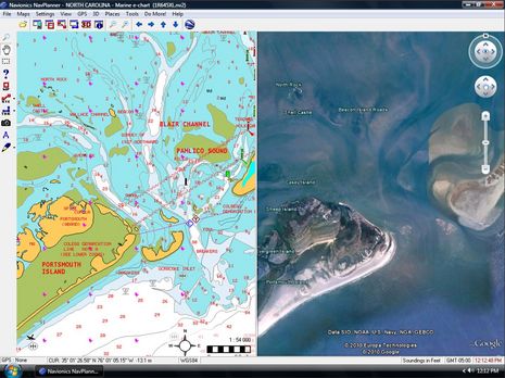
I've always liked the idea of route planning software, but Navionics NavPlanner was somewhat troubled from the start. Hence it seems like great news that Navionics dumped it entirely in favor of a partnership with Fugawi, leading to this recent joint announcement of NavPlanner2. Fugawi figured out how to present Navionics data well years ago, and then went on to produce the excellent Navionics HotMaps Explorer. Judging from the NavPlanner2 screen shot above -- which shows off Google Earth synchronization -- it shares a lot of code with the HotMaps lake planner. But NavPlanner2 has many added features...
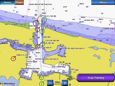
Today Garmin announced that updated 2010 g2 and g2 Vision BlueCharts are now available, apparently with some interesting changes. If you recall, the company got pretty excited about the 2009 edition, but then suffered some grief when a processing error caused a global recall. I'm not sure the 2009 charts ever got out, but I'm darn sure that all new editions go through some serious quality control. I can't really tell from the screen shot above what the "redesign" talked about in the press release is like, because it largely involves "transitions between zoom levels" and other possibly valuable improvements that you need to see in use. But I did immediately recognize that busy harbor as Little Creek, VA, because I once departed to Bermuda from there, and there are a few new features that print can describe better...