Navionics Mobile, UGC & Plotter Sync

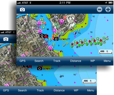
Big, big news in the world of user generated content (or UGC, or crowd sourcing, or whatever we decide to call it): Navionics Mobile 5, rolling out around the world as I write, supports UGC, big time, and it's central to the company's "Navionics Anytime, Anywhere" vision of the future. Those screen shots above -- which show the new "Community Layer" turned on and off -- are from a beta of US East 5.0 running on the Panbo test iPhone, but most all of that UGC work was done by Navionics founder and chief visionary Giuseppe Carnevali when he cruised up here in early September. It would be hard to overstate Giuseppe's enthusiasm about enabling interested Navionics users to share data of all sorts, some of which can be validated and added to the company's regular chart database for the benefit of all users...
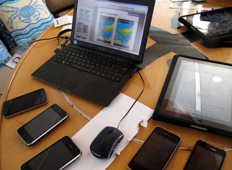
Captain Carnevali is cruising with quite a collection of iThings these days, though his power catamaran is fitted with loads of dedicated plotters as well. At any rate, the multiple wireless app devices seen below meant that Guiseppe could show me how a UGC change he made on one immediately showed up on the others, no sync routine involved, as long as all were online. What I haven't seen in action yet is "Plotter Sync" though apparently it's already been demoed at one show with a Raymarine E Wide. The idea is that you'll be able to plan a trip anywhere on your smart phone or tablet, and when you step on the boat its fixed nav system, networked to a WiFi router, will see your device and suck up the routes you already created.So far Plotter Sync details are vague, except for some chatter on the Navionics Facebook page, but it sure sounds good to me, and it's yet another way that the marine electronics developers are challenged to work with the onslaught of iThings, as discussed earlier this week. And apparently there's lots more to the Navionics Anytime, Anywhere program -- like free apps with chart card purchases, and easy frequent data updates to those cards, I think -- but I'll wait until I can get more concrete info. However, I can share some details on the UGC that's in the Mobile 5.0 apps now working their way through the iTunes store...
 First of all, the Navionics approach to crowd sourcing is in many ways quite different from what Active Captain has been working on since 2006. For instance, as you can see in the top screens, Giuseppe was able to add all the Camden channel buoys that NOAA tried to include in its chart updates last spring (but which still haven't made it into any of the commercial charts that copy ENC and RNC data). And had the buoys been on the chart already, but misplaced in several cases (due to a funky private aid application filled out by our Harbor Master), he could have moved them. In the community layer that change would show up with a "x" where the buoy had been. None of this is possible in AC right now, though I was able to post an AC Hazard note about the buoy confusion and see it sync to Coastal Explorer 2010/2011 almost immediately. Then again, Navionics doesn't yet support the marina ratings, let alone much of the marina detail, that AC does, nor can you see who generated the content, which I've come to value in AC.
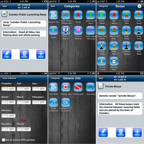
 In the top left screen below you can see what happens when I tap on the Launch Ramp Icon that Guiseppe added to the chart you see way above. In fact, I've already edited it, adding the "Information" text, so this is communal UGC now. The next screen shows all the master categories you'll see when you tap anywhere on a chart and then select "Add Object." And the top right screen shows how well populated the Buoy category is. Starting at bottom is a bit of the lengthy Marina data input screen, and then the choices available in the Generic Info master category. I used "Text Note" to add more explanation to the channel buoys (and also managed to demonstrate an odd spelling disability I have around a few words like "buoy," which I've typed a zillion times, but can still screw up ;-)...
 Navionics UGC is just coming out of the gate, and there are numerous question marks, like just how they're going to validate critical data like rocks and depths with enough confidence to add them to their regular chart database. In fact, a comment today on their Facebook page -- "In time, Navionics may verify user's contributions and decide to implement them in official charts." -- is more tentative than what I've heard from other Navionics staff. But there is no question that this move validates the whole idea of crowd sourcing in a big way. And there may be no one who feels happier about that than Active Captain's Jeffrey Seigle, who's been trying to explain the concept for years. Yesterday, Jeff told me that if he could, he'd do what Apple did in 1981 when IBM finally introduced some competition into the infant personal computer market. Which was to take out a big "Welcome" ad.

 Share
Share
Incidentally, yesterday Jeff had enough news about ActiveCaptain (which I can't share yet) that he too could legitimately start an "AC Anytime, Anywhere" marketing campaign ;-)