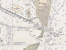
OK, I’m obsessed with charts, but I’m not the only navigator thus afflicted. Last week I used a snippet of a wonderful 1685 chart that’s available on the Net, and promised to tell more. The source is the U.S. Library of Congress Map Collection. The LOC has scanned scads of cartography at very high resolution for your viewing and downloading pleasure. You’ll see several categories, none of them “nautical charts” per se, but you’ll find all sorts once you dive into the search engine. Shown here, and larger here, is a bit of a 1921 chart of Miami. It’s interesting as an early example of color use, and also because it shows a Miami Harbor that’s damn shallow and missing some major features like Fisher Island and the whole cruise ship dock area.
You can zoom into the detail of these charts nicely on the LOC site, especially if you have a fast Web connection, but there’s a problem if you want to download one for further perusal or printing. Many are in an unusual format called MrSID that no standard graphic program I know of can read. The solution is IrfanView, an excellent freeware (or “beggar ware”) program created by a young Bosnian named Irfan Skiljan. IrganView can turn this 6.6 meg .sid file of Miami into a 90 meg .jpg file that would print nicely full size. The LOC offers some maps and charts for areas outside the U.S., but if there are richer sources I'd sure like to hear about them.
Another important feature of the new Max and Platinum chart card formats I wrote about earlier today is their vastly expanded POI (Points of Interest) databases. Click on an icon and you can find out a marina’s phone #, services offered, and much more. Ditto for hotels, grocery stores, and other services. One electronics wag predicts that eventually we’ll be able to check out the menu at a dock-and-dine restaurant before we tie up. But this stuff is not entirely new. Contemporary paper charts don’t include POI info, but old time cartographers were often artful with it. The snip below is just a couple of square inches from a panoramic of the New York City waterfront that fills one corner of a 1685 chart of New England. Many points of interest are labeled with letter keys, including the gallows (G), illustrated in use! Click here for a larger image of the chart (a new Panbo feature). I’ll write an entry soon on where to find high resolution antique chart images like this on the Web.
Why do C-Map’s full page ads for its new Max chart format feature a woman wearing a cartographic body suit? Even the model looks like she thinks it a goofy idea! Especially since Max has so many interesting and graphic new features — panoramic photos of harbor entrances, animated tidal current predictions and navigation light characteristics, street mapping, 15 levels of land contours and 32 of depth (now in 256 colors), and a perspective view that let’s a navigator see chart detail up close to the boat while still keeping an eye on what’s further ahead. And none of it has been seen on plotters before. C-Map has a dedicated Max site here. I wrote about Max and Navionics’ new Platinum format (not much on the Web yet) for the June issues of PMY and Sail, and we tried to use as many illustrations as possible. I think that both new formats are sexy, but not literally!
Lowrance started talking about its new NauticPath electronic charts last fall, but the details — cost, which plotters they’ll run on, and “where the heck did Lowrance get them?” — are still resolving themselves. You may still find Web references to regional cards at $99 apiece, but it’s definite now that Lowrance will ship (very soon) all U.S. coastal charts on one card for $109 retail! And a new page at Lowrance says that the Great Lakes, Bahamas, Puerto Rico, and USVI are also included! The same page indicates that most every plotter in Lowrance’s fast-growing line will run these charts, though a firmware upgrade may be needed. So one sweet possibility is backing up a boat’s plotter system with an inexpensive waterproof handheld loaded with charts, and also able to play MP3 music! By the way, at a Miami Boat Show press conference, Lowrance allowed that NauticPath is based on the same Transas chart database that Nobeltec and Garmin licensed as the foundation of their electronic chart formats.
Lowrance has a phenomenal number of new products this year, and the specs on many of them will likely prompt more exclamation points here.
Garmin’s new 192C plotter and 198C plotter/sounder come with full detail BlueCharts for all U.S. coastal waters, including Alaska and Hawaii, loaded in non-volatile memory and ready to use! This is remarkable news because until now you had to also buy either chart cards or a CD with which you burned your own chart card. Either way, getting charts for, say, a trip down the East Coast could cost more than the total $964 price tag on the 192C, and was more hassle. One possible downside of the pre-loaded charts is that you won’t have a card or CD that you can use with a backup plotter. It’s also not clear how Garmin will update these charts, or if they will work via USB for planning on a PC. I look forward to trying one of these five-inch diagonal units, which also boast “a new look and feel”, in the near future.
Garmin’s charts-included strategy, which will likely come to other new models as they roll out (just guessing), is only one of several major changes in the world of electronic charts that I’ll try to touch on here over the next few weeks.
I really like this cooperation between Marinalife and Maptech. It will make life easier for boaters by integrating lots of services with Maptech's interface. I hope this is just an example of what to expect in the (near) future.
"Marinalife has created a centralized Internet-based reservation system for marinas, kind of an Expedia for recreational boaters that it calls a "cruising concierge" system. The five-person company is combining its system with technology developed by Amesbury, Mass.-based Maptech to bring a range of navigation and communications tools to boaters on the water. Maptech has consolidated and simplified a range of electronic navigation technology that enables boaters to check the weather, access radar images and send and receive e-mail with a few touches on a computer screen. By joining forces, the two companies aim to become an online travel agent of sorts for boaters. They'll be able to create navigation charts and, from the water, reserve a slip at a marina and make dinner and hotel arrangements for after docking."

 OK, I’m obsessed with charts, but I’m not the only navigator thus afflicted. Last week I used a snippet of a wonderful 1685 chart that’s available on the Net, and promised to tell more. The source is the U.S. Library of Congress Map Collection. The LOC has scanned scads of cartography at very high resolution for your viewing and downloading pleasure. You’ll see several categories, none of them “nautical charts” per se, but you’ll find all sorts once you dive into the search engine. Shown here, and larger here, is a bit of a 1921 chart of Miami. It’s interesting as an early example of color use, and also because it shows a Miami Harbor that’s damn shallow and missing some major features like Fisher Island and the whole cruise ship dock area.
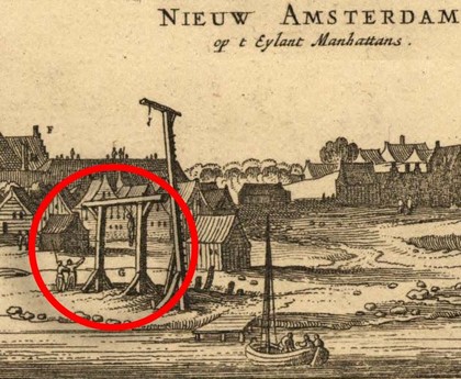
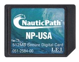 Lowrance started talking about its new NauticPath electronic charts last fall, but the details — cost, which plotters they’ll run on, and “where the heck did Lowrance get them?” — are still resolving themselves. You may still find Web references to regional cards at $99 apiece, but it’s definite now that Lowrance will ship (very soon) all U.S. coastal charts on one card for $109 retail! And a new
 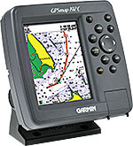 Garmin’s new
  I really like this