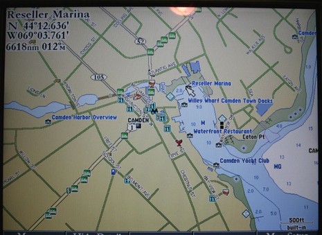
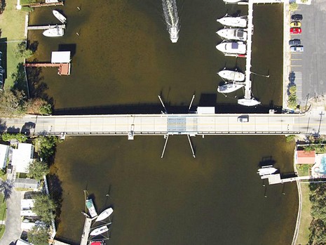
Garmin G2 cartography was announced in November, more detail came out in March, and now I’m actually looking at it, both versions. Yes, remember that G2 (or g2, as Garmin spells it) comes in two tiers. The 3210 I’m testing has G2’s of the whole U.S. built in; they are full detail charts with added major roads and some port info. But you have to buy and insert a G2 chart card to get all the photos, full street maps, and multiple POI’s seen above, and bigger here
. Pulled back a bit you’d see that there are about a dozen photos just for Camden, which rather amazed me. Some are oblique, some straight down, many are higher resolution than you’ve ever seen in a navigation product before. For instance, I can make out my 14’ Gizmo tied up in the shot below (bigger here). Garmin has a ways to go to make all this photographic wealth easily accessible—like making the icons more indicative of what the picture shows, and making it possible to page through all of a port’s pics without going back out to the chart—but I’m sure it will happen. I also see a few errors in the port data but that’s nothing new. For instance, almost every electronic chart shows Willey Wharf and the Camden Town Landing as one place with a common phone number, but they are quite separate operations (there’s either been a lot of copying or data licensing going on). Also “Reseller Marina” is completely new to me and I’ve been in this harbor for 35 years and am on the Harbor Committee! I’m looking forward to trying the 3210 and G2’s, both versions, on the water soon. (The cards, by the way, retail for $215 in Garmin’s regular sizes, and $321 in large sizes. And speaking more generally of chart data sources I was interested to see this list of hydrographic offices including what Garmin has signed up for.)
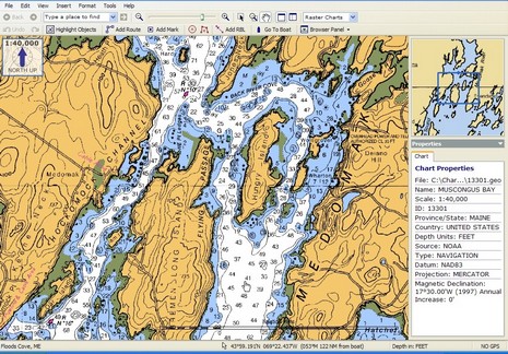
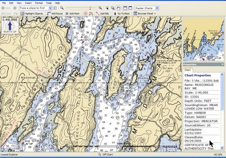
I took my first Maine boat ride of ‘06 yesterday (yahoo!), launching my 14’ power cat Gizmo at Broad Cove Marine Services in Bremen and exploring Hungry Island. The salty Maine expression for waters like these—i.e. lumpy with lots of hidden ledges—is “bony”, and I was a bit frustrated navigation wise. The only plotter screen onboard (silly me) was a tiny, poor-in-direct-sunlight Magellan. We did have a paper chart, but it was the reduced Waterproof Chartbook version of the most detailed available (1:40,000 scale), handy but hardly good enough in place like this where you where you really wish there was a high detail chart, like 1:20,000. At any rate it got me thinking about the SoftChart color palette I spoke of last week. Check it out: here’s full screen of the SoftChart above, and full screen of the standard NOAA RNC below. Don’t those rich colors clarify some of the important cartography? I wonder if Maptech will adopt these colors for paper as well as digital charts? I also wonder if the company will expect premium pricing for more richly colored charts?
Note to Coastal Explorer/CNP users: did you realize that right mouse clicks neatly change the scale of the chart overview window (as shown)? And finally, for a nice picture of Gizmo at Hungry Island, click here.
Maptech’s freeboatingcharts.com is now offering a DVD with all current NOAA raster charts, all Corp of Engineers river charts, and a real charting program for $50. The charts are organised on the disc into 23 ChartKit-style regions, and this deal even includes technical support. The software is Offshore Navigator Lite, the same program that now comes free with Maptech’s printed ChartKits and Waterproof Chartbooks. It’s not great, but it’s not bad either. I’ll try to write more about it soon, as well as the Zeus thing I started! Have a great weekend.
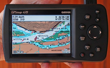
I suppose it was predictable, but it’s still amazing. The Garmin 478 above has all the XM Weather and Audio abilities that distinquished the 376C, and it comes loaded with all U.S. charts and all U.S. and Canada road maps. It’s fast too, even the ‘Find’ command is not slowed up by what must be a zillion POIs, nav aids, intersections, etc. stored somewhere in that little casing (and hence I’d bet that Garmin has sped up Find in the first all-U.S.-charts 192C I tested last summer).
Not that the 478 is perfect, even if there is nothing like it out there. For instance, these are the new G2 charts, but apparently the 478 will not be able to show the vaunted perspective view. I do gather from the spec page that it will show the photos available on G2 cards, and the screen above (bigger here) does look richer than regular BlueCharts. But, as good as this screen is, I find myself wanting to plug the 478 into a bigger monitor, maybe use a wireless keyboard and mouse with it too. The unit lets you use an expensive XM subscription anywhere you go but in some of those places, like a boat, you may want to expand the system. Just a thought, probably inspired by how rapidly this unit has evolved over the years.
I should also add that the Panbo reader who recently complained about the “Surface Wind” coming from XM to this machine was right; it’s old. He tells me that Garmin has acknowledged the problem and is working on it, but I also noticed this time around that you don’t get predicted wind and wave model data, something the new Sirius Marine Weather is very good at.
Garmin also announced a new pair of radar scanners this week, this time inside a smaller, 24” diameter casing, and with more emphasis on the digital processing going on in there. Finally, though Garmin hasn’t yet promoted it, many of its new plotters apparently do support AIS. The 478 is not one of them but I think I’ll soon get the chance to try it on a 3210.
Today I realized that Garmin has put up more information about their second generation BlueCharts, including the screen shot of the perspective view above, and the unusual top-down high-res photo below. Garmin announced G2 in November along with a boat load of new gear, which is all now coming to market. I’m on the list to see the G2’s on a couple of new plotters, and, of course, will report here. I also came across some surprises on Garmin’s Web site, some seemingly only accessible by randomly appearing links: a new blog; a very cool looking Smart Phone mapping software/data system with combo Bluetooth GPS, speaker phone, and cell mount (whew!); and a mapping program for certain cell phones already GPS enabled. There’s also Nuvi. No location awareness stone unturned!
Does it strike you as peculiar that Navionics is packaging their new NavPlanner software with a special multi card reader? Heck, didn’t Navionics spearhead the move to standard memory cards? Aren’t all its current products on either CF or SD formats? Wasn’t there once a rumour spread by the likes of me that Navionics was thinking of putting a free planning program on every card? That’s true, but dates to the days when Microsoft had assured Navionics that its chart files could be simultaneously protected and read using normal MS file features. That turned out to be untrue, and that’s why you need a special reader to view Navionics charts on a PC. I think the same is true of C-Map, whose charts now come on SD cards too. So it goes. Using standard memory cards in plotters still makes it easier to do firmware updates and save waypoints, and also reduces overall chart card costs. NavPlanner, by the way, is still not shipping, but “very close”.
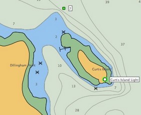
There are two aspects of the above screen shot that you have probably never seen before. One is the chart itself, which is meant for fishing, not navigation; hence no shore detail or nav aids, but way more bathy data than you’ve ever seen for this area. Navionics calls the card Fish’n’Chip and is giving it away with regular Platinum cards and its new Gold+ cards. It’s all part of their Silver/Gold+/Platinum product strategy, noodled about here and fully revealed here. And note that the screen shot was taken using a beta of Navionics’ much awaited PC planning program, NavPlanner, shipping soon. Here’s the cool thing: I’m in Miami filming two PMY videos about Navionics’s whole chart line and today will my second of trying all the cards aboard a charter sportfishing boat. I have a lot more to report, but no time right now.
Are you old enough to remember Superman on TV? “It’s a bird! It’s a plane! It’s Superman!!!” That’s what came up in my fuddled brain when first presented with Standard’s first-of-its-kind what-the-heck-is-that? VHF and chart plotter combo machine. If you look close, the screen above is an obvious dummy, but I saw the unit running in Miami and was impressed. That screen is a 7” wide style—hi res (800 x 480 pixels) and hi bright. The CVP fully supports C-Map Max and its interface looked quite polished up compared to the old CP series (which wasn’t bad). The radio is full Class D DSC with a 30 watt hailer/horn built in, and you can add two RAM+ or telephone style mics if desired. You can also hang a black box fishfinder on this ($1,100 MAP priced) thing, making it quite the all-in-one for, say, a center console fishing machine or a tuna tower, or a sailboat helm. The designed-in ‘handle’ on the right side might be useful in those places too. Of course all the DSC benefits of interfacing GPS/plotter and VHF come built-in, just add an MMSI to get position with distress call, plot your buddies, etc. By the way, that area of marine communications is about to get a boost as Sea Tow rolls out an interesting new marine operator service called Sea Smart. More on that in few weeks.
* Happy to report that FreeNavCharts.com—torn into pretty fiercely here last month—really has cleaned up its act, and is now an informative Web site and a useful service.
* I’m told that Lowrance does acknowledge that certain rocks are missing from NauticPath charts, and says they will reappear in NauticPath version 2, coming out in about 6 months. Also added will be drying heights, seabed composition, anchorage areas, obstructions of uncertain depth, and more. Lowrance does not usually offer an upgrade path for cartography (it is very reasonably priced, after all) but is “considering” a special policy regarding NauticPath.
* The new 3.1 version of MacENC will now properly display those same rocks, as shown here. And I’ve heard from The Capn folks that they’ve not only solved their ENC rock display issue but have also figured out ways to display certain other valuable ENC chart details that “no one else is showing”. Examples are coming. This whole experience has made me a little leery about ENCs, if not all vector charts, but Panbo does indeed rock!
Enroute to Miami today; will report on the Boat Show this week as possible.
A French software company called Just Magic has created some neat Google Earth placemark files (.kmz) and has links to others of nautical interest. That’s part of a NOAA chart above (slow loading as you might expect) plus links to world wide XTide tide stations and bouy weather stations (you can click and go to predictions in both cases). And here’s a page that uses Google Earth to track the Volvo race. Will we be navigating on GE eventually?


 , anchorage areas, obstructions of uncertain depth, and more. Lowrance does not usually offer an upgrade path for cartography (it is very reasonably priced, after all) but is “considering” a special policy regarding NauticPath.