I just got the new Captn. Jack’s catalog, which seems pretty quick given that Maptech just took over the operation a few months ago. The online Captn. Jack’s is also back in business, which means I can link you right through to some of the more interesting offerings:
* The fictional Jack is indeed bundling Maptech Chartbooks with Garmin plotters, as above, including putting all the on-paper waypoints into the plotter. Just the product combinations themselves look like decent deals, the waypoints a very useful bit of frosting. (I’m hoping to try the feature out).
* The Capn software (no previous relation to Captn. Jack, and different spellings retained) has now become CAPN Integra AIS, and there’s some more detail on how Maptech plans to market it. Jack is also selling the U.S. Boating Charts DVD, which I have tried (it’s excellent), both alone and nicely bundled with Memory Map.
Note that Captn. Jack’s is offering free ground shipping and a money back guarantee (though a tight one). Altogether it’s a pretty neat catalog, and probably the one most focused on marine computer navigation, though it still doesn’t thoroughly cover the products available. Isn’t it strange that Captn. Jack’s once offered almost every major ECS except the Maptech ones, and now it features Maptech’s even larger roster but is missing major products like Nobeltec, MaxSea, and RayTech?
“Navionics welcomes Boeing’s escalated commitment to the marine electronic charting market. No doubt, this will help both the technological and the regulatory part of the business mature and provide a better service to the mariner, ultimately increasing safety of navigation as well as expanding the market.”
Mind you that for over 20 years Navionics and C-Map have each been run by their respective Italian founders, Giuseppe Carnevali and Fosco Bianchetti, two gentlemen who were once partners and seemed to compete both enthusiastically and graciously. This is a big change in the little industry the two dominated. It could mean new opportunities for Navionics, or it could be challenging, but I think we can safely translate the statement above into a simpler term — “Game on!”
Intermittent WiFi in Cuttyhunk, fog in Fisher’s Island Sound, a greasy scallop and bacon pizza, one engine overheating…it was a hell of a cruise, really! I’ll share more later, but I’m tickled to arrive home and find that two Panbotes e-mailed me about the late Friday news that Boeing has bought C-Map. Wow.
I didn’t see this coming, and am not sure how it will work. The strategy stated in the press release is that C-Map will help Boeing’s Jeppesen subsidiary, already huge in aviation mapping, grow its marine division. I find it a little odd that the release never mentions Nobeltec, which seems to be the only real meat currently at Jeppesen Marine, even if it’s only listed under “Recreational Solutions”. It’s obvious that C-Map’s commercial vector charts will fit nicely into Jeppesen’s commercial goals but what happens to Nobeltec’s Passport charts? And what about the various recreational electronics products, like Standard Horizon plotters, that are actually built by C-Map? And does this affect BNT ME, i.e. Navman/Northstar, for sale and fairly committed to C-Map cartography? Your comments welcome (and a big thanks to Aaron and Milt for the head’s up).
PS, 8/21: I’ve called the various companies involved and no one can really say much during the “quiet period”, i.e. the 90–120 days it may take to have the deal OK’d by various regulatory bodies. But I did learn a little: * C-Map’s hardware manufacturing, as well as aviation/land navigation products, are actually separate companies, and are not part of this deal. * Jeppesen says it has every intention of continuing and improving C-Map’s existing OEM operations, i.e. no worries if you have a plotter using C-Map cartography. * The folks at C-Map and Nobeltec (and, of course, Jeppesen) all sound excited about future product strategies (that they can’t really talk about yet).
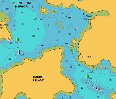
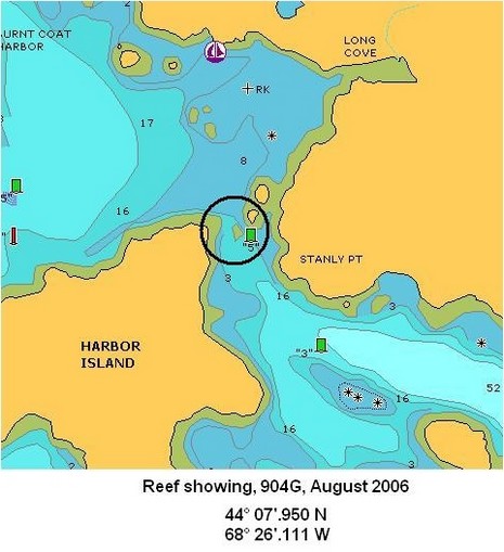
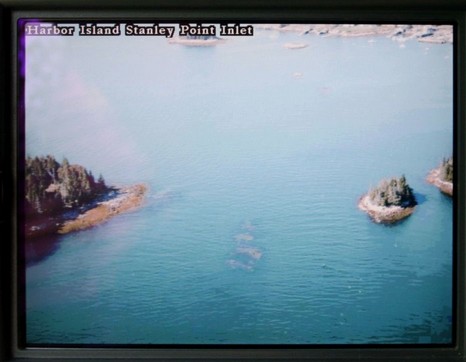
I promise I’ll stop writing about this ledge soon! But it does turn out that Garmin’s optional BlueChart G2 cards, first discussed in May, look good in terms of the great Burnt Coat Harbor bent prop incident. That is the guilty ledge just showing in this photo, taken at approximately mid tide; you can even make out the Can right (east) of it, especially nearer full resolution. Note too the trees on the little islands, a helpful detail that the Cruising Guide chose to emphasize in its sketch chart. Below you can see how the photo icon shows this shot’s view angle. Notice the multitude of photo icons! There’s also a straight down of this same ledge, a view from the north, several pulled back views of the whole channel, something like 12 pictures all together. By contrast, neither Maptech nor C-Map Max has any panoramic photos of this harbor, and Navionics Platinum has 3, but much more pulled back. Could I have missed a photo? You bet; no one seems to have the perfect photo interface yet, and with such a large inventory, Garmin has further to go than most. They’re working on it; the improved icon just arrived in a recent release. Mind you that Garmin’s cards are fairly pricey (especially considering that users already have the G2 charts themselves build in), but I do believe them when they say they’ve spent heavily on helicopter photography.
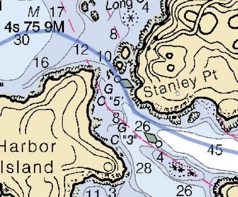
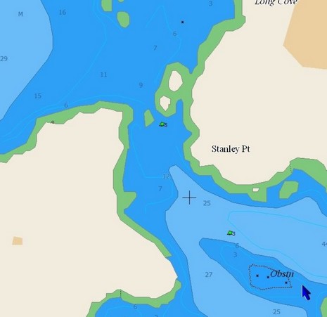
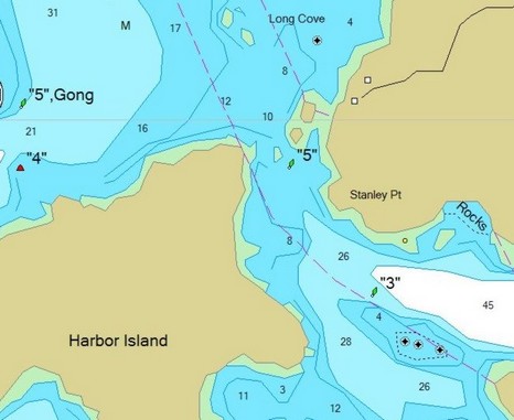
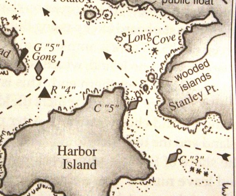
Why haven’t more people who use Navionics charts experienced a C “5” ledge misfortune? Certainly one reason is the Taft/Rindlaub Cruising Guide to the Maine Coast, which contains the sketch chart excerpted above and is consulted in biblical fashion by many cruisers. Notice how useful those dashed arrows are, especially as the overall bouyage—if you happen to be passing right through Burnt Coat, as many do—changes from red right to red left (or vice-versa, because both passages are returning from the sea to a harbor). Heck, my 1979 Duncan and Ware Cruising Guide to the New England Coast talks about how an “able vessel can beat through” this passage “leaving the two cans to starboard”. And that was before chart plotters even existed (and sailors were gnarly navigators, especially Roger Duncan!) Going to the other end of the spectrum, look below how Navionics’ own Platinum grade chart shows the ledge, if you have the top-down photos turned on, including the “land & sea” option (full screen here). There are many ways to get by that Can without damage. But before anyone starts judging yesterday’s ledge leaper a fool, they should take another look at the plain Navionics chart image, excerpted at right. It’s a clean-looking, easily-read chart, just what we’ve been asking for. But not only did Navionics leave out the ledge, the very vector gods (who actually ‘draw’ these charts) conspired to worsen the error. Look how the extra big Can symbol (which I like) hides the fact that there’s any water at all between it and the little island (though, mysteriously, not below). My point? Vector charts are “smart”, they really are, but sometimes not as smart as a cartographer placing a Can just so on a paper chart, or someone who’s been there simply sketching some guidance.
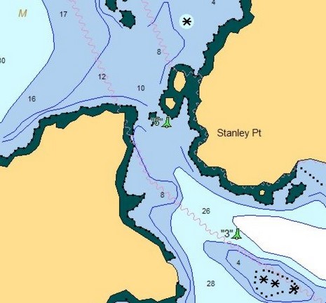
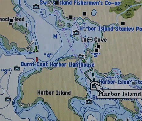
This is what the gentleman saw on his Raymarine plotter, bigger here, which is why he says he cut between Harbor Island and Can “5”, and that’s why he’s now hauled out having his bent props, and maybe more, repaired. Ouch! Navionics missed a ledge, a pretty important one. In fact, the thing is vaugely drawn on the official NOAA raster chart, heavily zoomed below (and also showing my fortunately uneventful track through the same beautiful area last summer), but still every other brand of vector chart I looked at did manage to get it right. (The images futher below—C-Map, Garmin, and then Nobeltec—all show the ledge and are interesting to see side-by-side, but note that how they display varies a lot from one device to another and also according to how variables are set). Now, I believe that electronic charts are pretty reliable (the Lowrance NauticPath and ENC display issues aside, probably all fixed by now anyway). But I also suspect that every vendor—even NOAA (by the way, the 1:40,000 ENC for this area hasn’t been issued yet)—makes mistakes. Just like the splash screens and navigation manuals say, reliance on a single data source is not a good idea (especially when the bouyage appears confusing, which in this case will get another entry). In the meantime, I’ve learned from Navionics that this error has been reported and will be corrected in the next regular annual update if not before.
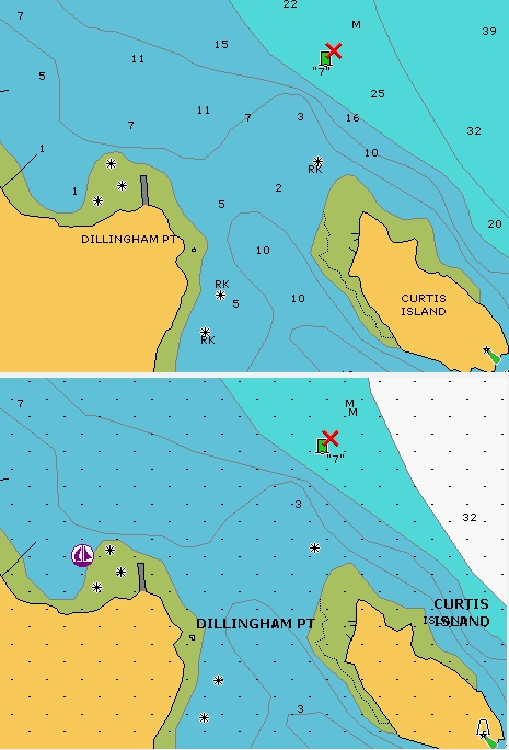
While I’m back on the subject of charts, Curtis Island in particular, I want to correct an error I made last Winter. That’s when I made note of how my borrowed C-Map Max card seemed to have lost track of Camden’s largest aid to navigation, the Curtis I. light. It was confusing, as I noted, but it turns out that I wasn’t completely wrong; the early versions of Max had an overly aggressive decluttering algorythm that could sometimes declutter something as important as that light. However, what I did not understand was that C-Map had discovered and fixed the problem quite rapidly. The reason I didn’t know about the fix was that I had a card that didn’t come through normal channels, plus I didn’t call C-Map to ask. And there, friends, is one weakness of Panbo. I kind of shoot from the hip on this blog. When I write a magazine article I have the time to make calls and check facts, but here I’m hoping that readers will notify me of mistakes and I’ll correct them online. Please feel free to note those mistakes, and hopefully I’ll correct them faster than this one! At any rate, C-Map’s Max card not only shows the Curtis Island Light at every appropriate zoom level, it also has a picture of it.
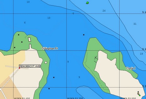
I first heard about Navionics Silver all-in-one card last October, and the whole Silver/Gold+/Platinum (plus Fish’n’Chip) strategy was revealed in February. You can now buy a Silver card—at $116 (discounted) for coverage of the entire continental U.S. coastline, Great Lakes, and Bahamas—but are the charts as detailed as the ones on the more expensive cards? Above, on top, is what a Platinum or Gold card looks like at 1/2 mile range on a Raymarine E or C-Series plotter. It’s a pretty faithful copy of the 1:20,000 harbor chart of the Camden Rockland area (which, by the way, is not included in the paper ChartKit). Underneath it is a 1/2 mile range using a Silver card; the dots indicate that you’re over-zoomed and, in fact, the spot soundings are based on the 1:40,000 coastal chart of the area, seen below. However, the critical rocks and coastline detail come from the 1:20,000 chart, as you can see off Dillingham Point and the west end of Curtis Island. It also seems that some deep water contours have been removed from Silver and the extra data like marina information is minimal. But, still, Silver is “almost as good as Gold” (as Navionics told me). (The Bahamas are excepted as Silver uses the old, crude HO stuff rather than the private data that Navionics is now using on its better cards.)
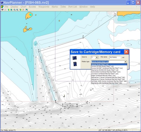
Navionics kindly sent me soon-to-be-shipped version 3.13 of NavPlanner, but I’m afraid it’s not going to satisfy the critics (some of whom ganged up on this software rather fiercely at The Hull Truth). The screen shot above shows all the plotter file formats it supports, as well as some interesting bathy detail off Key West on a Fish’n’Chip. 3.13 does seem faster, and it handled every kind of chart card without crashing, and I was able to build, save, and open various route types without trouble. However it’s still pretty clunky software. For instance, there is no simple hand grab tool to position the chart just where you want it, and when you try to move off the visible chart while mousing a route it doesn’t even know to pan without getting additional commands. Also you can’t change the type of depth unit used (usually an advantage of vector charts) and most U.S. charts are thus shown in Meters.
I could go on, but suffice it to say RayTech 6.0 handles Navionics charts much better, especially Platinum ones. In fact, even, say, Northstar users might want to do their planning in RayTech and then just use NavPlanner to convert the routes to their format. That’s possible (I checked), but there may be other ways to make the transfer, especially as RayTech will export routes to coma delimited or Excel formats. And note that Fugawi is just about to add Navionics card support to its ENC software. (Both Raymarine and Fugawi will sell the special reader needed for about $75).
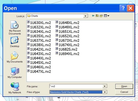
But if you are using NavPlanner, I can help you out with one annoying detail (that I’m told will be fixed in a future version). Right now NavPlanner (unlike most every other chart viewer out there) does not automatically, or even semi-automatically, register charts and then graphically show you what’s available. Instead you have to find the "Charts" folder and then pick your desired region from a coded list, like below. This is an extreme example as that’s a Silver card with the whole U.S. Coast on it, but even a regular XL3 card has 3 XL files on it. Which is where? Navionics doesn’t have an online code list but I found one at Boaters Land.
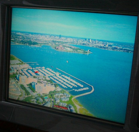
I’m pretty sure that Maptech was the first to add panoramic photos to its electronic charts, but now they’re everywhere. Nobletec Passport Deluxe, Navionics Platinum, C-Map MAX, and Garmin BlueChart G2 all have their own (or licensed) panoramas. But Maptech has upped the ante, at least on the SRN/i3, figuring out how to georeference the whole photos, not just where they were taken, so your boat can be overlaid on them. It is not critical for navigation, but it is cool. Check out the larger size image of the above panoramic showing Quincy’s Marina Bay with Boston in the background. I’m not sure the overlay always works out as neatly as this, but there in red is the Sea Ray I took this picture on, perfectly positioned in her comfortable home slip. Speaking of which, I am now comfortably back in Maine, my apartment and treatments in Boston all history. Hallelujah! I don’t care if it rains all weekend, and I hope you’re feeling the same.


 mage.
mage.