
Georeferenced panoramas, and happy to be home again
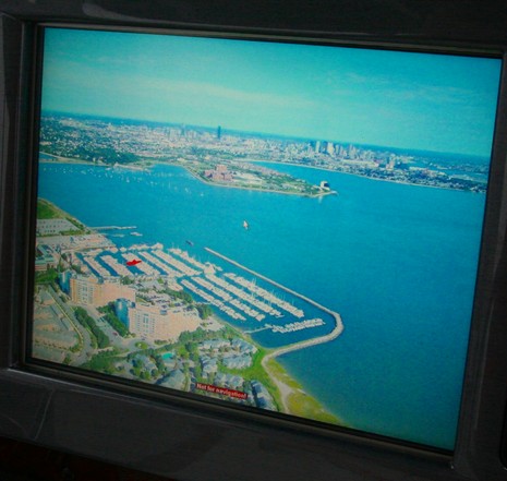
I’m pretty sure that Maptech was the first to add panoramic photos to its electronic charts, but now they’re everywhere. Nobletec Passport Deluxe, Navionics Platinum, C-Map MAX, and Garmin BlueChart G2 all have their own (or licensed) panoramas. But Maptech has upped the ante, at least on the SRN/i3, figuring out how to georeference the whole photos, not just where they were taken, so your boat can be overlaid on them. It is not critical for navigation, but it is cool. Check out the larger size image of the above panoramic showing Quincy’s Marina Bay with Boston in the background. I’m not sure the overlay always works out as neatly as this, but there in red is the Sea Ray I took this picture on, perfectly positioned in her comfortable home slip. Speaking of which, I am now comfortably back in Maine, my apartment and treatments in Boston all history. Hallelujah! I don’t care if it rains all weekend, and I hope you’re feeling the same.
Another useful addition to mapping imagery would be a skyline view. Based on existing chart data, the expected terrain profile would be computed as it would be viewed from a gps position and in a selected direction.
A very welcome home.