
NavPlanner 3.13, still needs work
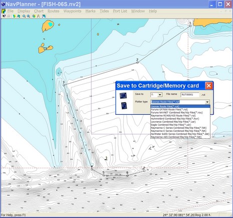
Navionics kindly sent me soon-to-be-shipped version 3.13 of NavPlanner, but I’m afraid it’s not going to satisfy the critics (some of whom ganged up on this software rather fiercely at The Hull Truth). The screen shot above shows all the plotter file formats it supports, as well as some interesting bathy detail off Key West on a Fish’n’Chip. 3.13 does seem faster, and it handled every kind of chart card without crashing, and I was able to build, save, and open various route types without trouble. However it’s still pretty clunky software. For instance, there is no simple hand grab tool to position the chart just where you want it, and when you try to move off the visible chart while mousing a route it doesn’t even know to pan without getting additional commands. Also you can’t change the type of depth unit used (usually an advantage of vector charts) and most U.S. charts are thus shown in Meters.
I could go on, but suffice it to say RayTech 6.0 handles Navionics charts much better, especially Platinum ones. In fact, even, say, Northstar users might want to do their planning in RayTech and then just use NavPlanner to convert the routes to their format. That’s possible (I checked), but there may be other ways to make the transfer, especially as RayTech will export routes to coma delimited or Excel formats. And note that Fugawi is just about to add Navionics card support to its ENC software. (Both Raymarine and Fugawi will sell the special reader needed for about $75).
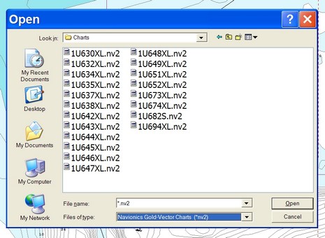
But if you are using NavPlanner, I can help you out with one annoying detail (that I’m told will be fixed in a future version). Right now NavPlanner (unlike most every other chart viewer out there) does not automatically, or even semi-automatically, register charts and then graphically show you what’s available. Instead you have to find the "Charts" folder and then pick your desired region from a coded list, like below. This is an extreme example as that’s a Silver card with the whole U.S. Coast on it, but even a regular XL3 card has 3 XL files on it. Which is where? Navionics doesn’t have an online code list but I found one at Boaters Land.
I would like to see a moving map GPS that could display the NOAA ENC charts. Advantage besides cost; are frequent updates and most important they are official and "legal" for navigation.
I know none of the major manufactures are likely to touch this one, but I can wish.
Thanks Ben for keeping us informed!
Pat Harman