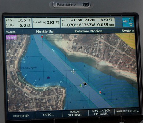
Navionics just announced its new Platinum+ chart cards, which I got a peek at along the coast of Cape Cod last month. As the name implies Plus, or “+”, takes Platinum’s numerous features up a notch, or two. The top down photo maps and panoramic port photos are higher res, the bathy data underlying the 3D screens is more detailed, and the coastal pilots are more tightly integrated. I was particularly struck by the photo maps.
Yesterday I got to spend a few hours on a Navionics test boat tooling around Bass River, Cape Cod (unfortunately damnable cars and planes were also involved in the trip). A few of us boating writers got to fool with eight chart plotters, and see first hand what Navionics is up to for 2008 (very cool, but I can’t write about it just yet). Another highlight was spending time with company founder Giuseppe Carnevali. This is not the first demo cruise I’ve taken with this gentleman and I’ve come to appreciate his fathomless enthusiasm for cartography, the technologies that make it better, and boating. He’s been a creative force in marine electronics since he and Fosco Bianchetti developed the first vector charts in the early 80’s. Yesterday it occurred to me that with Bianchetti selling C-Map and Darrell Lowrance finally retired, Giuseppe is one of the last of his generation still pushing this field forward. And he’s going strong.
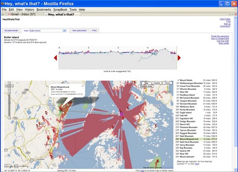
Continuing on about how we’ve just gotten started with electronic cartography, check out the demo video at Perceptive Pixel showing the developers exercising two handed control over Google Earth and other imagery. Then there’s Microsoft’s new “Surface Computing”—also “multi touch”—nicely presented by Popular Mechanics on this video. It sure seems possible that the ‘surface’ could be one wizbang chart table…eventually. Meanwhile, Google has introduced Maplets, which means that users can now contribute mini applications as well as content. And Michael “heywhatsthat” Kosowsky has already created three, two of which I used in the mashup below (and bigger here). One very usefully overlays Michael’s topo lines and the other guesstimates new shorelines if sea level rises. Just add 150 feet and I’ve got waterfront!
PS 7/18: “…a quantum leap from our 2d/3d apps like Google Earth”? Check out this video about Seadragon and Photosynth (thanks, John!).
Pardon a slightly meta sidetrack, but two bits of the massive media flow got my attention. One is a Wired article about Google Earth which makes the case that the future of cartography is user data. “We're all mapmakers now, which means geography has entered the complex free-for-all of the information age, where ever-more-sophisticated technology is better able to reflect the world's rich, chaotic complexity.” Then there’s the news that scientists have calculated that the diameter of the globe is about 5 millimeters less than thought. Not even a quarter of an inch! Among other techniques, they used atomic clocks, quasars, and 70 radio telescopes to establish base lines, and they say that the precision they are after will help to better measure phenomenon like global warming, ocean currents, and tides. As amazed as most of are by all the information now available on a yacht’s bridge, I think we’ve just gotten started. (For some really interesting dope about related planet dimensions, and early cartography, check the beginning chapters of Nigel Calder’s How to read a nautical chart, which also has practical uses!)
PS 7/12: It turns out that Captain Richard Rodriguez, who has a thing or two to say about the Boston ferry collision (see his fine blog), has also used Google Maps to mark the most frequently hit rocks in the San Juan Islands. What I’m talking about!
Where is this bubbling geographic/Internet stew going to take us (like EarthNC), and, in particular, what the heck else is being created nearly under my nose (like ActiveCaptain)? The latest is a rather amazing service created by one Michael Kosowsky out in the Lincolnville hills west of Panbo HQ. It began with Michael wondering what distant bumps he was seeing from his yard and now--much programming later--he's inventor/proprietor of Hey, what's that. Check it out. Right off the bat you'll see what's what from Mt. Battie, which happens to be where I took the header photo of Camden Harbor above. You'll see it centered in Google Maps with each visible peak marked by an icon, along with a panorama view above and a list of the spots to the right, each interactively clickable. But you've just gotten started.
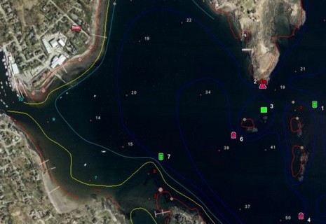
Following up on yesterday’s entry, here’s what the full EarthNC Plus looks like in my home harbor. Note the spot soundings and bathy lines. The 1:20,000 harbor chart has not become an ENC yet, but this represents all the essential data from the 1:40,000 coastal chart overlaid on what’s in many places (like Camden) the highest resolution photography available. But, of course, Google Earth’s photos live online, and as best I can tell, EarthNC Plus does not yet have a way to cache them to a laptop. Plus the suggested method of GPS navigation on these charts is Goops, which didn’t impress me.
EarthNC has come a long way since December. For one thing there is now an official Web site. And a few weeks ago the company introduced EarthNC Plus, a $50 CD package that can overlay all available ENCs on Google Earth. I’ve been testing it, and will write more about it soon. But today let’s look at EarthNC Online, the just introduced free viewer. You have to install a plug-in from GoogleEarthAirlines which lets you access G.E. from inside your browser. Sounds a little dicey, but it all worked fine for me (using Firefox 2.0).
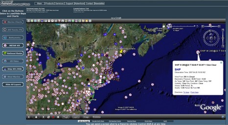
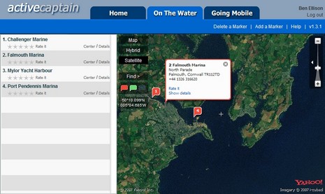
I’m pleased to hear that ActiveCaptain, the “Point of Interest bomb!”, is active indeed. Yesterday developers Karen and Jeffrey Siegel announced that the free site now has over 9,000 marinas and almost 1,000 anchorages, with 35,000 updates and 1,000 reviews from some 2,000 registered users. (And, by the way, hats off to our own frequent commenter “b393capt”, who is the second most prolific “Active Captain”). You can see the informative results of all this activity if you register and scan the U.S. coastline, and pretty soon the Siegels are going to add a “Local Knowledge” marker meant for favorite restaurants, hikes, uncharted shoals, etc. Plus ActiveCaptain is going international. Already, for instance, there’s seed information for 500 marinas in the U.K.—as in Falmouth, Cornwall, above—ready for you Brit Panbo readers to elaborate on. Please do!
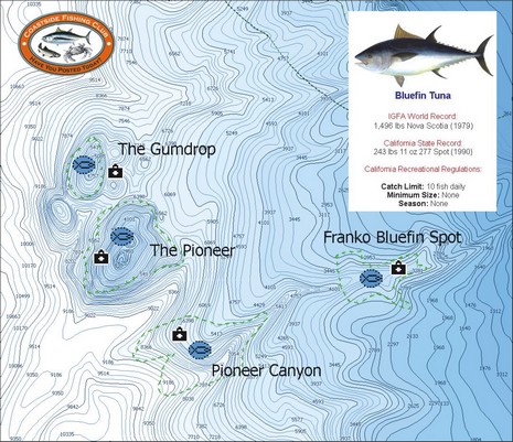
Yesterday another reader emailed, “What's new is the fishing electronics world? It is Spring time, and we just had the salmon opener here in San Francisco!” Well, how about a C-Map MAX Coastside Fishing Club chart card full of hi res bathymetry and other goodies useful for fishing from Pt. Conception, California, to Coos Bay, Oregon? Actually I’m a little confused by the press release’s mention of “exclusive Member’s Only fishing data like IGFA and state record information, local fishing regulations and favorite fishing spots of club members.” C-Map’s catalog seems to indicate that the card is available to anyone, the Coastside Fishing Club makes no mention of it, and, besides, it seems pretty similar to C-Map’s other Max Fish Bathy cards (see 2/06 press release). Maybe someone can straighten this out? And, if you go way off San Francisco, keep an eye out for the unusual radar semi-submersible SBX-1, spotted with an AIS receiver setup that’s purportedly seen targets 1000 miles away.
PS 4/12: It turns out that this card is available to the public, but what most distinguishes it from the Max Fish card covering the same area is the inclusion of hot spots provided by the Club. Thank you Coastside!
NDI, or Nautical Data International, just announced that it’s selling its exclusive right to produce and license digital versions of Canadian charts back to the Canadian Hydrographic Service (CHS), effective on March 30. It sounds like that’s the end of a long and unpleasant affair I’ve discussed before, but who knows for sure? If you read the Q&A’s, you’ll find that NDI plans to stay in business, and to continue its suits against C-Map and Navionics. I haven’t followed this dispute closely, but have noticed that both those companies are now offering very reasonably priced Canadian charts, especially when compared to NDI’s PC charts. In fact, I know boats that have gone from PC to plotter mainly because of that price difference. Here’s hoping that CHS will make Canadian rasters and ENCs more affordable and easier to use.