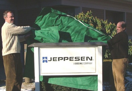
As noted earlier today, the deal went down. Above is the scene this morning at C-Map USA’s Mashpee, Massachusetts, office as Operations Manager Chris Cox and General Manager Ken Cirillo unveil their new sign. Similar events took place at other C-Map offices around the world, and a press release went everywhere. The latter is a bit vague, but a Jeppesen spokesperson at the Denver headquarters gave me a little more color on what this acquisition may mean to marine electronics. The most specific item is that Jeppesen Marine’s recreational division, i.e. Nobeltec, will be integrating C-Map cartography into its products, though it may take six months or more, and the fate of Passport Charts is “yet to be determined”. Otherwise C-Map will be “business as usual”—i.e. same partners, sales outlets, and customer support facilities—at least during the six months it will take to integrate the company into Jeppesen. And the notion that C-Map’s hardware manufacturing facilities were not part of this deal, posted here back in August, was also confirmed. As for that distinctly non-marine logo, the spokesman said they are working on a new branding scheme, but it’s hard to give up the plane after such longterm success serving that market. In fact, Jeppesen supplies 80–85% of commercial aviation operators with not just cartography, but weather, routing, and other essential data. At one point, the company printed two billion sheets of paper per year (!), though now, of course, this data has largely gone digital. Jeppesen is obviously an aviation powerhouse (and so was C-Map in the marine world), which is why the ad they’ve been running in some of the commercial marine magazines—now modified for C-Map’s home page—has weight. It reads, “What happens when a company with more than 70 years of experience pioneering navigational and operational information management solutions for aviators enters the marine market?…The game changes.” But, despite the hints, I guess we’ll have to wait to see exactly how.
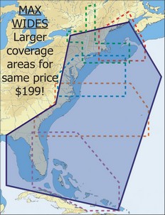
It’s a happy day for navigators when C-Map is running out of adjectives to describe how large an area is covered by its latest chart cards. The press release is not online yet (update), and C-Map’s Web chart catalog doesn’t yet show them, but last week the company announced that in 2007 Wide-size cards will cover about five times the area for the same price. That means, as shown right, that $199 will get you every chart from the Canadian border through the Bahamas and up the west coast of Florida, with all Max features like animated tides & currents, custom C-Marina charts (like below, which I like a lot), and photos of inlets/harbors. $249 MegaWide cards will also get super-sized, one purportedly covering the entire East Coast, Caribbean and the Gulf Coast. Another covers the Gulf of Mexico, the Caribbean and all of South America, and a third covers the entire West Coast of Canada and the U.S. If you visit C-Map this morning you’ll see that the Jeppesen deal is now official, which I’ll have more on later today.
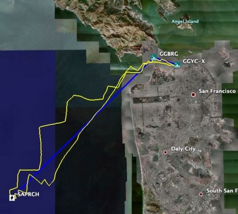
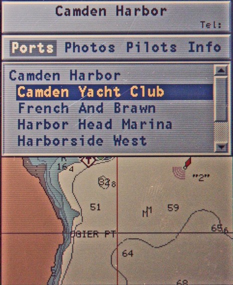
Following my whining about the clumsy POI interfaces seen on many plotters and charting programs, Navionics sent up a powerful handheld they make (but would rather not advertise here, as it’s only available in Europe). They’re proud of how easily POIs can be found and browsed, and well they should be. There are at least two ways to get a list of local marinas, for instance, and the one below graphically points them out as you page through. Once selected, the particular marina's phone # goes into the title bar at top and right arrowing through the categories shows you what photos, Pilot book, or other info is available, and then you can drill down. When you get to, say, “other services” in the “info” section, nearby businesses with their own POI info are in blue and clickable. There are almost no dead ends, i.e. the interface doesn’t let you click for more information about something if there isn’t any (a gripe I have with Raymarine’s access to this same POI info). At any rate, Navionics made its point; a much better way to get at all this data is possible on even a small plotter. But that doesn’t make the data any more accurate. For instance, that’s not exactly where the Camden Yacht Club is (below). But some good news on that score is coming later this week. Posting will be jagged, though, as I’m on the road to points south (a little south).
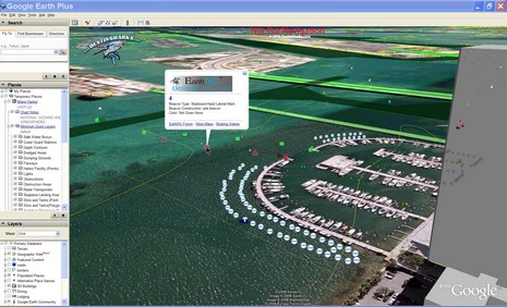
It seems obvious that Google Earth and similar online mapping systems that allow users, individual and otherwise, to create their own overlays will somehow figure in the future of marine navigation, at least for sharing POIs and planning. But, get this, a small Florida company, DestinSharks.com, is already translating NOAA vector charts (ENCs) into Google overlays they’re calling EarthNC charts. I heard about it (thanks, Rich and Rich), signed up for the public beta test, and am impressed. I was getting fancy in the screen shot above (bigger here), using GE’s tilt mode and 3D buildings, but check out how neatly the nav aids, bottom contours, and dredged channel lines lay out, and how (left) you can control overlay elements in familiar GE fashion. But I do hope they figure out how to round the depth soundings back to their original paper chart equivalent (a vector issue I’ve complained about before). And I did see registration issues between some EarthNCs and GE satellite photos (though in this case, Miami’s Sea Isle Marina, the charted pilings seem to line up perfectly). DestinSharks, by the way, is “planning a DVD edition which will offer the full chart set for offline use”, and Google recently added photo maps of my home harbor that are almost as detailed as the most zoomed-in marine panoramas I’ve seen (so far). What else will 2007 bring?
PS 12/28: I came across the fact that Google Earth was downloaded 100 million times during the ten month period following its June, 2005, release as a free program. Yow!
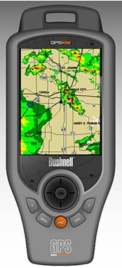
EliBoat made a good catch last week, spotting this Bushnell ONIX400CR GPS and XM handheld. The specs, as spied out by the sat radio blog Orbitcast, look impressive—waterproof, 3.5” screen, XM weather & audio, aerial and satellite photo overlays—and all supposedly retailing for $500 when the product ships in February. That’s a big discount from the Garmin handhelds that offer this same great ability to carry your XM subscriptions from boat to car to house, etc. Mind you that Bushnell shows no interest in the marine market; its thing is hunting, as shown by its Web write up for sister product ONIX200CR. Still, I want to try one and see if it might make sense, even without nautical charts, as a boating accessory. This product, by the way, is an ‘honoree’ in the Wireless Peripheral category of the 2007 CES Innovations Awards, always a geekerrific list.
More good news on the cost of marine electronics front: Navionics is apparently going from XL3 to XL9 Gold+ chart cards, three times the area for the same $200 price. That’s the whole East Coast and Northern Bahamas on one card, with full NOAA chart detail (unlike the Silver all-one-cards), plus “enhanced port services” POIs (flawed though everyone’s may be), coastal roads, and a mail-in coupon for a free Fish’n Chip bathy card. This price drop is not on Navionics’ Web site yet, and may not be effective until 2007, but Peter James of Jack Rabbit Marine has the scoop on his new blog, askjackrabbit.com. A blog by a guy who professionally installs marine electronics? Now there’s some really good news.
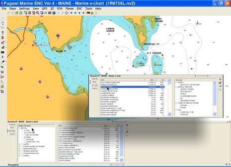
I’m working on a column about the “Points of Interest” we get on electronic charts these days. I think they have wonderful potential, but these days are often inaccurate, plus hard to use. Above, and full screen here
, is an example of an interface that seems to work pretty well, Fugawi ENC’s new ability to work with Navionics Gold+ (Platinum too, but many features aren’t supported yet). Note on the inset how you can easily search for harbors and marinas by distance from your present position, or (inset) narrow your search by multiple service criteria. Some other charting programs, and particularly plotters, are clumsy to search, lead you to empty data screens, etc. Plus, like every other electronic chart I’ve seen (all available, I believe), there are numerous errors/ommisions in the POI location and details presented here. Where, for instance, is info on the Camden Public Landing, possibly the POI of highest interest to visiting boats? So I have some questions for you all:
* Do you use electronic POIs when boating, or do you prefer printed guides, or both, or do you just ask around? * Which electronic charts have you tried and what’s good or bad about each’s POI data and the particular interface used? * What’s the future of POIs. I see a lot happening on land—like automated (Bluetooth) POI calling, user generated POIs and georeference photos, sites dedicated to sharing such info, etc. Not to mention Google Earth, Microsoft Live Local, etc. How and when will these advancements come to boating?
In a way, this photo, bigger here, doesn’t do Argonaut’s new Tflex-G615 monitor justice, but then again I took it at the NMEA Conference with a Canon XT flash aimed directly into the poor thing’s LCD. Try that with a conventional lap– or desktop screen! It is indeed noteworthy that Argonaut has come up with a “waterproof sunlight readable” monitor under a grand, but do note that its claimed 2,000 NITS transflective equivalency is figured in direct sunlight. I’m going to test one soon and will be interested to see how it does in bright situations without direct light. Note, too, all the added features—optical bonding, multiple inputs, wider range dimming, PiP, etc.—that you get with the Tflex-G515, the same underlying LCD, I think, but costing nearly three times the money.
More good pricing news: * Apparently due mostly to lowered memory card costs (all the data for an XL3 size region usually requires two Gigs of space), Navionics has dropped the price of Platinum cards from $499 to $299. Plus there are more Platinum regions available, like in Europe, and US cards still include the right to a free Fish’n Chip (which, by the way, deserves better Panbo coverage). * And, get this, Captn. Jack’s is now offering Maptech’s U.S. Boating Chart DVD for $19.50, still with free ground shipping, money back guarantee, and technical support. And here I thought this a great value at $50. But this special holiday price may not last long; I guess ‘Jack’ wants to get noticed.
Man, that’s a long time in planes! I’m back in Maine, briefly, and experimenting with Google Earth to scrap book my trip. Here’s the full screen image, but it would be far better to open Google Earth and zoom around with me. 1 marks the touristy V&A waterfront, said to be the most visited spot in all Africa, and still worth visiting. Naturally that’s the hang out of the hot daysailing cats—Fuji and GQ—as well as visiting yachts. If you zoom in close you can see the canal that leads to the big hall (2) where the Boat Show was held and I met the Whisper builders. Pan further west to the commissioning docks (3), where the Magnum 32’ was parked. You’ll also see a line of cats getting ready for their long delivery trips. It’s said that in the wee hours of almost every night another big multihull is trailered through the streets of Cape Town. Finally, just for fun, the 4’s show where an elevated highway was once going to bypass down town, but one property owner held out, and now it will never be finished. “This is Africa!” my hosts explained. Speaking of GE, MacENC can now neatly export tracks, waypoints and routes to it, as shown below and bigger here. And recall that Vessel Tracker can plot live AIS targets on it, and Just Magic has created all sorts of interesting mashups. Now we just need a reasonable way to get broadband underway. That’s the sort of surprise I’m hoping for at NMEA (Thursday) or Ft. Lauderdale.
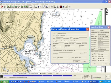
It’s really worth clicking here to see the full screen showing Maptech’s Offshore Navigator Lite (ONL) program included on this $50 DVD I first mentioned last April. I don’t know why I didn’t write more about the package sooner—we’re a little scattered here at Panbo!—but I certainly was impressed with it, particularly the professional level Notice to Mariner updates illustrated in this screen shot. See that orange circle around Northeast Pt. light just right of the Camden Harbor label. Clicking on it brought up the NTM dialog box that fully explained the what and when of the change. I find that very useful for keeping up on the changes in my local waters, waters where I tend to think I already know what’s what! They moved NE Pt. light a little ways; good to know! On this particular chart (learned via the other dialog box), I can see every NTM change from its Base Date of 4/29/2003 through 3/25/2006, shortly before Maptech sent me the DVD. Now I’m wondering if there is an easy way to keep these charts updated, easier than going to freeboatingcharts.com (which also markets the DVD, along with Captn Jack’s), and downloading lots of whole charts. Are the update files online somewhere? Is there any software that can semi-automatically keep a specific portfolio updated?
By the way you can simply turn off the NTM feature in ONL, so you only see the latest chart, no circles. Also note the “Navigation Panel” at the bottom of the screen. Those blue bars represent different charts available at this location, the light blue meaning that I’m at the largest scale (smallest area). Mousing over the other bars would show me their titles and scales. I’ve always liked that. Altogether this DVD—which includes every NOAA raster plus the Corps of Engineers river rasters, all organized by region, plus a GPS wizard—is a hell of a deal. But if you are looking for all the charts on DVD, you might also consider a new product from Managing the Waterway, a $40 2–DVD set that also includes the ENCs and demos of various charting programs. I’ll be checking it out soon.
I’m very glad that BoatU.S. keeps a boater’s eyeball trained on the government, but, man, it must be hard to understand what’s going on sometimes. The organization’s latest concern is a Congressional budget proposal that cuts “the President’s request for Mapping & Charting and virtually zeroed out any funding for converting existing paper charts into electronic files.” Say what? The piece goes on to lay out all the reasons why that is a bad idea, including the idea that conversion to ENCs will save money eventually. Anyone guess why congress thinks this program a waste?

 It’s a happy day for navigators when C-Map is running out of adjectives to describe how large an area is covered by its latest chart cards. The press release is not online yet (
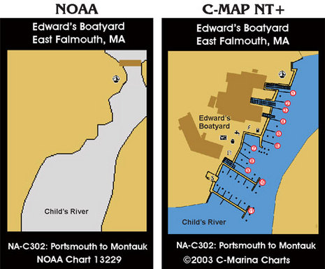

 EliBoat made a