
POIs, what do you think?
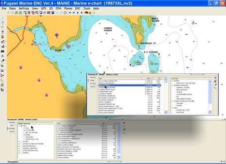
I’m working on a column about the “Points of Interest” we get on electronic charts these days. I think they have wonderful potential, but these days are often inaccurate, plus hard to use. Above, and full screen here , is an example of an interface that seems to work pretty well, Fugawi ENC’s new ability to work with Navionics Gold+ (Platinum too, but many features aren’t supported yet). Note on the inset how you can easily search for harbors and marinas by distance from your present position, or (inset) narrow your search by multiple service criteria. Some other charting programs, and particularly plotters, are clumsy to search, lead you to empty data screens, etc. Plus, like every other electronic chart I’ve seen (all available, I believe), there are numerous errors/ommisions in the POI location and details presented here. Where, for instance, is info on the Camden Public Landing, possibly the POI of highest interest to visiting boats? So I have some questions for you all:
* Do you use electronic POIs when boating, or do you prefer printed guides, or both, or do you just ask around?
* Which electronic charts have you tried and what’s good or bad about each’s POI data and the particular interface used?
* What’s the future of POIs. I see a lot happening on land—like automated (Bluetooth) POI calling, user generated POIs and georeference photos, sites dedicated to sharing such info, etc. Not to mention Google Earth, Microsoft Live Local, etc. How and when will these advancements come to boating?
I believe for coastal crusing the internet needs to be the way to go. When it first got going as a public resource, I envisioned a series of sailing/cursing home pages which yachtsmen could access with a PC on board, at Net Cafes or any of the numerous WiFIU hot spots etc.
What I envision then (and still do) is for example the Long Island Sound Page. The site would offer real time current data about the region, weather and tide infor (just click on a location on the map and get the data... or marine services... restaurants, historic information, races and recreational amenities (bowling whatever) shops and ground transportation information... you name it. Why use the same out of date concept of a crusing guide... good as they are when the data can be more robust, and constant current! It's the wave of the future.
I say keep the paper charts and use the most advanced web based data resources. All the stuff in between, like plotters etc are fun but their charts too are needing to be updated. I like the idea of real current real time data bases possible with the internet.
No?