
Navionics Silver, how much detail?
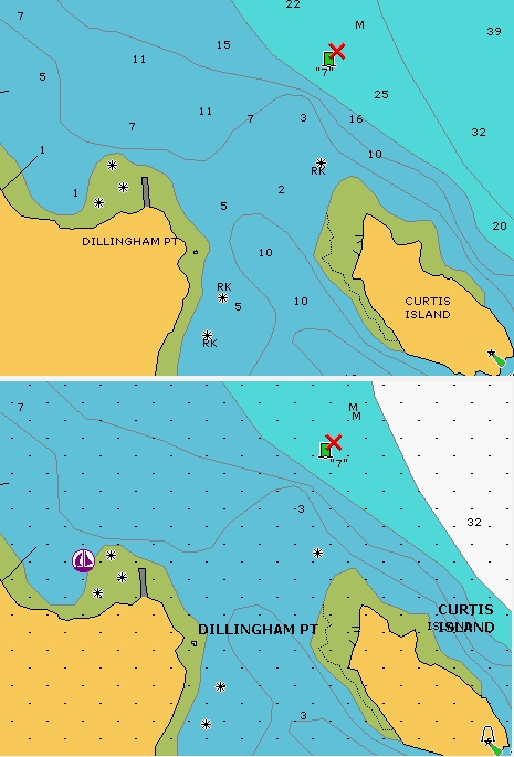
I first heard about Navionics Silver all-in-one card last October, and the whole Silver/Gold+/Platinum (plus Fish’n’Chip) strategy was revealed in February. You can now buy a Silver card—at $116 (discounted) for coverage of the entire continental U.S. coastline, Great Lakes, and Bahamas—but are the charts as detailed as the ones on the more expensive cards? Above, on top, is what a Platinum or Gold card looks like at 1/2 mile range on a Raymarine E or C-Series plotter. It’s a pretty faithful copy of the 1:20,000 harbor chart of the Camden Rockland area (which, by the way, is not included in the paper ChartKit). Underneath it is a 1/2 mile range using a Silver card; the dots indicate that you’re over-zoomed and, in fact, the spot soundings are based on the 1:40,000 coastal chart of the area, seen below. However, the critical rocks and coastline detail come from the 1:20,000 chart, as you can see off Dillingham Point and the west end of Curtis Island. It also seems that some deep water contours have been removed from Silver and the extra data like marina information is minimal. But, still, Silver is “almost as good as Gold” (as Navionics told me). (The Bahamas are excepted as Silver uses the old, crude HO stuff rather than the private data that Navionics is now using on its better cards.)

This is the information that I have been looking for for a long time. Thanks ever so much.