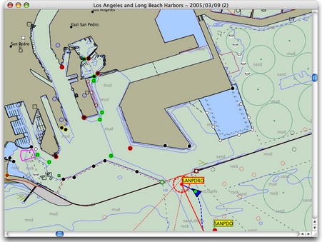
It was just last week that Rich Ray sent me this screenshot of MacENC, a new version of his GPSNavX charting program that supports NOAA’s free ENC vector charts. But after Tuesday’s news about free raster charts, it no longer seems like a big deal. Now we know that by about next spring Rich and other developers will probably be able to sell their charting software on a DVD that includes the digital equivalent of every single NOAA U.S. paper chart, without any encryption hassels and at little added cost. And users will be able to update those charts weekly if they want (making that easy will be another chance for developers to add value). But ENCs aren’t going away. They’re better than RNCs in many ways, and they’re definitely the future. Eventually—when ENCs are perfected and coverage complete—NOAA will drop raster chart production altogether, even printing paper charts from the vector database (if they print charts at all). Right now it’s quite useful to have both RNCs and ENCs for the same area; each has data or display features that the other lacks. In fact, if I was a Mac person, I wouldn’t think twice about paying the extra $35 for MacENC. I’m looking forward to inexpensive DVDs loaded with both types of free U.S. charts.
By the way, breaking the raster story generated a record number of readers here at Panbo, and for a moment made me feel like Matt Drudge (in a good way). A big thanks to whoever it was out there e-mailing Panbo links all over the planet!
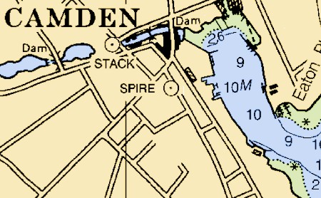
Wow! The CRADA (Cooperative Research and Development Agreement) that made Maptech the only official source of NOAA Raster Navigation Charts (RNCs, like the snip above, which are like paper charts) is over, and the new plan sounds terrific. Maptech will continue to use its expertise to produce/update the RNCs, but will deliver them weekly, in unencrypted .bsb format, to the Office of Coast Survey (OCS), who will distribute them over the Web. Anyone will be able to download them for free, including commercial vendors who can encrypt, add value, and repackage them (within certain guidelines). While this development has been rumored about for some time, this is now the official word from OCS, though “No date has been set by which this distribution of free raster charts will begin.” A free portfolio of U.S. RNCs—which, unlike the ENCs, is complete—will really stimulate PC and Mac charting programs and I think has already motivated some of the price slashing and big value adds in the vector chart segment (just check out the “charts” section of Panbo). Above all, I suspect it means that eventually just about every salt water boat in America will have some sort of plotting device aboard. Hats off to NOAA, and let’s hope that some the world’s other hydrographic offices follow its lead (don’t hold your breath).
Update, 8/10: I’m getting questions about how “official” this news really is. My source is a fairly formal e-mail sent by OCS to a developer. It seems quite genuine and clearly states what I wrote above. But please note the one sentence I directly quoted; we do not yet know when this will happen.
Update 2, 8/10: Another developer I know called OCS and spoke with the gentleman who heads up the RNC division. He verified the above and also said that their goal is to have all RNCs online by the end of this year, if not sooner.
Update, 8/11: Alright already! I finally did what a better (and less busy) reporter might have done in the first place; I spoke directly with the Public Affairs Officer at OCS. He verified this story completely, but said that NOAA didn’t plan an announcement until free downloading is immanent. So, no, you won’t find this on an official Web site, but, yes, it is official.
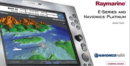
There’s finally some good Web material up about Navionics Platinum charts. Not surprisingly it’s at Raymarine’s site, as the E Series will be the first to display it. Definitely check out the “Feature Tour”, whose Flash animation illustrates some of Platinum’s dynamic nature. Raymarine calls this all a “Preview”, with the actual chart cards and E Series software upgrade “Coming Soon”. My sense is that it will be quite soon, as I’m starting to see ads too. Plus I’ve been trying out beta versions for a while now, and the software seems darn solid to me. Raymarine understandably asked me not to comment on beta product, but hopefully that too will change soon. In the meantime, one word: outstanding!
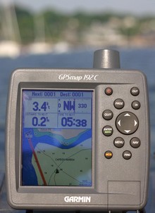
I was out testing in bright sunshine Saturday morning, and the screen on the Garmin 192C stood up very well. In fact this is the worst image I got, and it’s still quite readable (bigger here…note the glare, reflected elbow, and gunk on screen—real world factors you’ll rarely see in ads or articles). The 192 is the new unit that comes with all U.S. coastal charts in memory and ready to use. They really are all there, along with large area charts of places like the Bahamas, a good world map, and tons of port information. It is true that you can not use these charts with Garmin’s MapSource to do planning on a PC, but the no-PC-needed simplicity will be a plus for many users; even updating the charts will be done with a card. The only other con I could detect is that the find function is slowed down somewhat by the massive amount of data it has to search through. Besides the brighter, more color saturated screen, I noticed numerous subtle improvements in Garmin’s already effective tabbed interface. I’d guess the 192 will appeal to smaller boat owners wanting ready-to-use simplicity and flexibility (trailer north or south for vacation, get a card for lakes), not to mention cruisers who do big sections of the U.S. coast and want a backup to integrated and/or PC systems. The 192 comes with internal or external GPSs, and there’s a 198 version with fishfinder. Garmin won’t say if it might bring the all-US-charts-onboard strategy to other models, but what do you think? (Especially as Lowrance is offering this feature on many units).
I have no tolerance for boaters who rip off electronic charts; the practice hurts decent companies and has understandably led to copy protection schemes the rest of us have to cope with. But one chart manufacturer, Nautical Data International (NDI), has earned its own reputation for pirate practices. It ticked off customers for years with extra high prices, flawed encryption code, and even a “time out” mechanism that rendered charts you owned useless after a certain period. Two years ago, a nasty royalty fight erupted between NDI and the two big chart card companies C-Map and Navionics. You see, in 1993 NDI somehow wrangled not only the exclusive right to market electronic versions of Canadian Hydrographic Office (CHS) charts, but also exclusive right to negotiate royalty arrangements with other vendors. Many lawsuits followed, some still in court, but last winter CHS announced that it would terminate its relationship to NDI. Hence the strange press releases featured on NDI’s home page (right) proclaiming its ability to continue “business as usual” and its success suing the government office it’s dependent on. I bring this up because I recently helped a friend prepare for a Newfoundland cruise and can confirm that charts he bought from NDI five years ago will not run or reinstall on his PC. He will use paper charts rather than ever do business with NDI again.
An on screen personality I am not, a fact I was reminded of yesterday when circumstances led me to some videos I did for PMY almost two years ago. I did try to be informative about Navionics Gold, above, even if I was terrified that the fancy camera bungee corded onto Gizmo would go overboard. Life was better with a real camera man for the shoot about DSC calling and plotting using Standard Horizon gear (still a way underutilized technology, I think). Plus there were stripers involved, which I’m pleased to hear may be headed to Maine early this year (thanks, Eli).
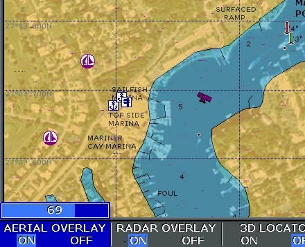
I’ve been getting requests to show more Platinum screens, so here’s one of what’s called Aerial Overlay. That means you can blend the regular vector charts with photo maps, which are straight down images that have been geopositioned so data (including your boat) can be plotted on them. Here the transparency of the photo map is set at 69% using the rotary knob on an Raymarine E120. Note how the photos improve your knowledge of what’s along the shore. Note too that the blending reveals descrepencies between the vector data and the photo map, a head’s up that one or the other is inaccurate. Platinum seems to include this resolution of photo maps for the whole U.S.; I understand the European version is lower res. Note too the camera icon, which shows you that there is also an “oblique” or “panoramic” photo available for this specific spot (wish we could all agree on nomenclature!). These are not geopositioned but do give you a useful perspective view of important inlets, marinas, etc. In Platinum they are quite high res (example coming).
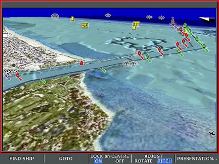
I have an article about Navionics’ and C-Map’s new plotter charts in the June issues of both PMY and Sail, but unfortunately neither is online yet. C-Map Max is shipping and there are good images of it here, but Platinum—which by design, and pricing, is the more ambitious product—is still a mystery to most anyone who didn’t get a chance to see it previewed at the Miami Boat Show. Above is a screenshot of 3D mode, which really should be a video to do it justice. You can see (bigger here) that critical chart data like buoys and wrecks are overlaid on a composite of land photo maps and underwater bathymetry. The soft keys on the Raymarine E120, which will soon be the first plotter to display Platinum, indicate how you can adjust the pitch and rotation of your view. There’s much more. One indication of how much more is the fact that Platinum comes on 2 Gig Compact Flash cards!
U.S. Navy Submarine Captain Kevin Mooney takes full responsibility for crashing the San Francisco into a practically uncharted undersea mount in the Pacific last January. Yesterday the New York Times published a detailed story about the accident, particularly the drama of trying to treat and evacuate mortally injured Petty Officer Joey Ashley. Then CBS 60 Minutes did a “Who’s to blame” piece, which I happened to see. The interviewer drew out how Mooney was using a classified, best-available Navy chart and steering a route sent from headquarters, but still the Captain—who seemed like an very decent man—insisted that he should have been going slower, should have checked other charts (where there were just hints of the mountain). Most of all, he said, “I should have been more skeptical about the chart data.”
Those are words to remember, especially as there’s a growing disconnect between our super precise electronic navigation and the precision of the underlying chart data. It’s a phenomenon I wrote about here.
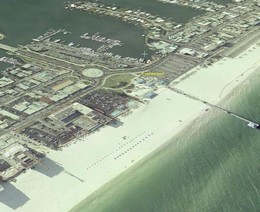
When Navionics Platinum chart cards come out this summer, 3D photo mapping will come to boat plotters. Platinum (still not much on the Web yet) is really going to turn some heads, as it did during the Miami Boat Show. If you want to see what the eventual possibilities are, take a look at NASA’s free program World Wind. It’s not quite as user friendly as Keyhole, but has higher resolution photography for much of the U.S. The screen shot above (bigger here) shows a Hilton in Clearwater Beach, Florida, where I’m attending a magazine meeting this week. In World Wind I was able to check out the beach and marinas, etc. before I got here. You’ll understand why posting may be irregular this week!

 I was out testing in bright sunshine Saturday morning, and the screen on the Garmin 192C stood up very well. In fact this is the worst image I got, and it’s still quite readable (bigger
 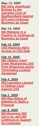 I have no tolerance for boaters who rip off electronic charts; the practice hurts decent companies and has understandably led to copy protection schemes the rest of us have to cope with. But one chart manufacturer, Nautical Data International (NDI), has earned its own reputation for pirate practices. It ticked off customers for years with extra high prices, flawed encryption code, and even a “time out” mechanism that rendered charts you owned useless after a certain period. Two years ago, a nasty royalty
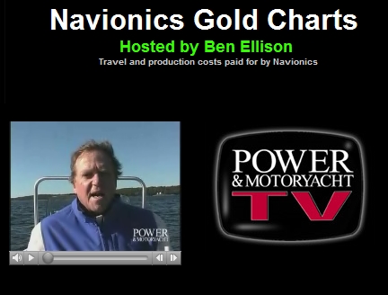

 When Navionics Platinum chart cards come out this summer, 3D photo mapping will come to boat plotters. Platinum (still not much on the Web yet) is really going to turn some heads, as it did during the Miami Boat Show. If you want to see what the eventual possibilities are, take a look at NASA’s free program