
Garmin 192C, for real
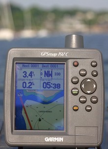 I was out testing in bright sunshine Saturday morning, and the screen on the Garmin 192C stood up very well. In fact this is the worst image I got, and it’s still quite readable (bigger here…note the glare, reflected elbow, and gunk on screen—real world factors you’ll rarely see in ads or articles). The 192 is the new unit that comes with all U.S. coastal charts in memory and ready to use. They really are all there, along with large area charts of places like the Bahamas, a good world map, and tons of port information. It is true that you can not use these charts with Garmin’s MapSource to do planning on a PC, but the no-PC-needed simplicity will be a plus for many users; even updating the charts will be done with a card. The only other con I could detect is that the find function is slowed down somewhat by the massive amount of data it has to search through. Besides the brighter, more color saturated screen, I noticed numerous subtle improvements in Garmin’s already effective tabbed interface. I’d guess the 192 will appeal to smaller boat owners wanting ready-to-use simplicity and flexibility (trailer north or south for vacation, get a card for lakes), not to mention cruisers who do big sections of the U.S. coast and want a backup to integrated and/or PC systems. The 192 comes with internal or external GPSs, and there’s a 198 version with fishfinder. Garmin won’t say if it might bring the all-US-charts-onboard strategy to other models, but what do you think? (Especially as Lowrance is offering this feature on many units).
How do I get a power cord and is their one for a car.