
World Wind photo mapping
... written for Panbo by Ben Ellison and posted on May 3, 2005
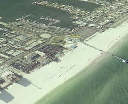 When Navionics Platinum chart cards come out this summer, 3D photo mapping will come to boat plotters. Platinum (still not much on the Web yet) is really going to turn some heads, as it did during the Miami Boat Show. If you want to see what the eventual possibilities are, take a look at NASA’s free program World Wind. It’s not quite as user friendly as Keyhole, but has higher resolution photography for much of the U.S. The screen shot above (bigger here) shows a Hilton in Clearwater Beach, Florida, where I’m attending a magazine meeting this week. In World Wind I was able to check out the beach and marinas, etc. before I got here. You’ll understand why posting may be irregular this week!
Leave a comment