CE in the UK, the Rowlandson POI extravaganza

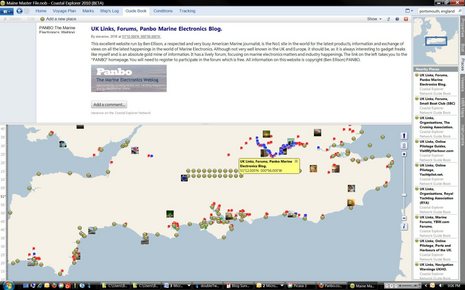
Back in April I enthused about the improved Guide Book section seen in the Coastal Explorer 2010 beta, soon to be official in CE 2011, but I didn't mention discovering all the UK and Euro data that's had been added using CE's own built-in Guidebook tool. I've played with the tool myself, and it's easy to create a POI with free form text, a link, and even photos. And it's easy to sync/cache all the Guidebook data stored on CE.net, like it is with ActiveCaptain, Atlantic Cruising Club, and other data sets (when your PC is online). But for some reason hardly anyone in the U.S., aside from the Pacific Northwest, has contributed Guidebook data. So how is it that England and nearby coasts are studded with all sorts of valuable port and marina Guidebook POIs -- and some more fanciful items, like that nice shout out to Panbo above? And what might it say about this whole crowd sourcing thing?
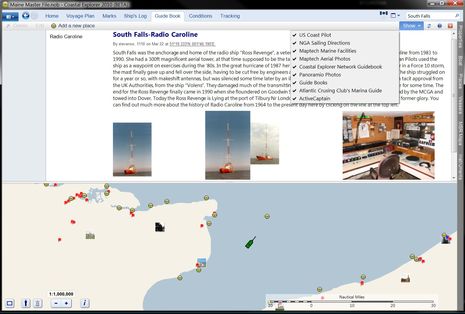
Well, it turns out that almost all those Guidebook icons seen in the screen above, and many hundreds more, were created by one man, Steve Rowlandson (who sometimes posts here as "steverow"). He's an avid boater and radio engineer who really got into the idea of using the Guidebook facility to its fullest. In fact, he made arrangements with VisitMyHarbour.com -- itself an interesting combination of professional and user content -- to include its general piloting data in Guidebook POIs along with links to the specific harbor sites. Steve is also working with Yachtpilot.net for more piloting coverage, and he's ventured into nautical history with his own POI creations. There's one off Rye, for instance, documenting the tragic capsize of the Mary Stanford in 1928, with a link to a folk song/video about it. And this one seen below nicely illustrates a famous pirate radio ship that used to occupy that spot in the English Channel.

Maybe some users would object to Steve's POIs about history or oddball electronics blogs as clutter, but I think the more info the better, as long as you can rid of it when you don't want it. In fact, it's darn easy to manipulate POI layers in CE 2010/2011, as seen in the check box above, and, besides all the guidebook info goes away as soon as you move along to another one of the top tabs. MaxSea TimeZero -- which I've now updated and linked with ActiveCaptain, and will write more about soon -- has a similar architecture and even let's you turn AC POI types on and off individually. Collecting and managing lots of professional and user generated guide content on one map screen is getting to be a big deal as more and more sources become available. And it will be interesting to see if Navionics new UGC data gets distributed beyond its own applications, perhaps even to programs like CE and MS TZ that don't use Navionics charts directly.
Perhaps no one cares more about the future of marine crowd-sourced data than people like Steve who've volunteered so many hours creating it, and naturally want to see their efforts available to as many fellow boaters as possible. Thus I wasn't surprised that he commented negatively when Rose Point announced that further access to the CE Network was part of a $99 CE annual update policy to commence 1/1/2011. (But Rose Point is now saying that all online services will stay free until mid March, and what it's now calling the "CE Services Package" only includes "Enhanced" Guide Books.) This is also why ActiveCaptain has had to continually assure frequent contributors that their work will be freely accessible forever. Navionics is a somewhat different situation as user generated data can theoretically become part of the company's very widely distributed chart database, but serious contributors will want to see how this works out in reality.
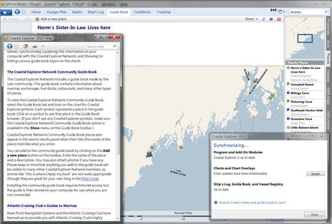
Steve Rowlandson's efforts are also an extreme example of how important power posters are to crowd sourcing. If nearly 75% of Wikipedia is the work of only 1,400 individuals (though that's debatable), I think Steve has outstripped even that ratio. I only see a handful of CE Guidebook entries all the way from Key West to Cape Hatteras, and my part of the coast is pretty sparse too, as seen below. And this particular POI -- the title is all of it, no mention of who Norm is, or why we should care -- is an example of the need for editing. The Guidebook facility, explained in that help file, lets other users comment on, but not delete or change existing shared data, and I'm guessing that no one at Rose Point has the time to clean up POIs like this that were probably meant for the similar, but private, logging and blogging features of CE. At any rate, anyone considering a serious time investment in marine crowd sourcing -- and I hope you are -- has several formats to go with, all with different abilities.


 Share
Share
Hi Ben,
Thank you very much for the entry.Totally unexpected.
In doing this, my sole reason was so that others in Europe can enjoy this wonderful forward looking Program for themselves. I couldn't have done it without the total support of Steve Bryant and Maury McKenzie at www.visitmyharbour.com and Rod Lord at www.yachtpilot.net, as well as help from Steve Ashton at the UK MetOffice and "shux" at the MCGA. It took about four months in total and I enjoyed every minute of it and learnt sooo much about our coastsline and marine heritage.
Users will also find three rows of links between London and the South coast which bring up sites of nearly evrything nautically "info" of interest in the UK and near Continental Countries. I'm still looking for the last four or five to complete the bottom row. (any suggestions anyone??).
It's a shame about East and North Scotland, it's not that there's nothing there, but it was difficult to find, and I would have had to go "commercial" to get the input, which for me defeats the object of a community guide book.
The same applied to Scandinavia and Germany, not really any pilotage web sites to work with, so I did as much as a could. It needs someone resident in those countries to take the project further and help CE do well there.
VMH has more Harbours to do in 2011 and I will ask if those can also be included in Ce.net. I think Eire, Northern Ireland and some more Scottish ones are planned. www.yachtpilot.net has also recently added the West of England to it's portfolio, and I will be including them as soon as time permits.
Kind regards to all and especially to all who made this possible.
Steve