
Navionics TurboView, a homage to NN3D
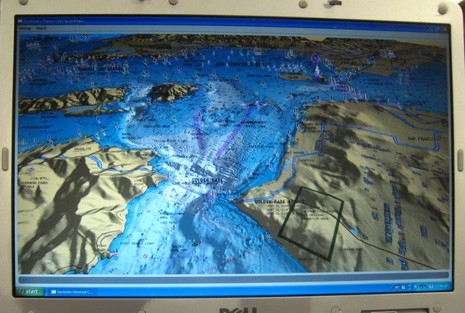
When Furuno NavNet 3D was first teased, I didn’t get the “native 3D” part. How could a “true 3D environment” be based on decidedly 2D raster and ENC charts? But I get it now. Whatever you see in NN3D’s conventional top-down 2D view—including routes, AIS targets, radar overlay, etc.—you can also see in 3D. It’s the same data, just tilted and shaded, and easy to fly around in. Which feels different—more “native”, more “true”—than any other 3D navigation I’ve tried before, and much more useful. So I think it’s great that Navionics has apparently developed a way to bring this sort of continuous-zooming, full-detail 3D to a variety of platforms. It’s called Navionics TurboView and I saw the preview above, and bigger here, at FLIBS.
TurboView is not new Navionics data, but rather a new way to look at existing Gold, Platinum, and Platinum + data. I gather that Navionics itself created the Turbo viewing engine, but that means little until manufacturers integrate it into their machines. Apparently the first will be Lowrance’s new HDS series, but others—including PC charting programs like Fugawi Marine ENC—will follow. In fact, the TurboView demo was shown on an in-house Navionics PC viewer, so I don’t know how it will look on real navigation platforms, or what overlays will be supported by whom. But the demo looked and panned/zoomed/flew beautifully.
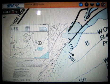
Meanwhile, you may recall that the actual NN3D had issues regarding its charts and how they presented at different zoom levels, especially on the small MFD8. The optional Navionics data isn’t available yet, but Furuno/MaxSea has rebuilt the raster and vector chart portfolio so that more data shows as you zoom out. The update should be available at Furuno soon but I got to check out an updated MFD8 at FLIBS and thought I could see a significant improvement in chart screens I’d seen off Cape Cod last June. For instance, I’m pretty sure that the original NN3D didn’t quilt a 1:10,000 chart to a 1:40,000 at the zoom level you see below.
Can someone explain why all this 3D stuff is needed for navigation? I had assumed that it was related to fishing (not a fisherman).
The 3D views are cool, but what is the practical use?