
V4 & P+, first impressions
I’ve been bench testing Raymarine’s E-Series V4 software update (aka 4.29) for a while now, mostly with a variety of new Navionics Platinum+ cards I borrowed. If you’ve read the comments to that V4 post, you’ll know that some upgraders have had to revert to 3.31, and I’m not surprised. There’s lots of changes in 4.29, and even my relatively unstressed test E-120—just a bit of N2K input; nothing attached via standard SeaTalk, SThs, or NMEA 0183 right now—goes a little twitchy sometimes. Like suddenly the 3D rotary controls don’t work unless I do a reset. And it invariably resets when I try to query the new STng (N2K) diagnostic screen, no matter what’s on the backbone. Plus I’ve yet to see P+’s live tide/current icons or the now built-in Fish’N Chip bathy data, despite another 4.29 flash and master reset (apparently Raymarine and Navionics are working on that latter one). However, I’d certainly recommend updating; just be prepared to go back to 3.31 if needed, and be on the lookout for the update to the update surely in the works.
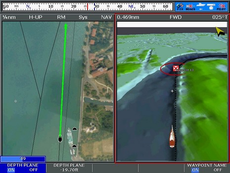
Now, for some good stuff, check out the above screen full size. I like the new compass bar, which you’ll notice indicates bearing to waypoint and also has steering hints that get more insistent the further off track you get. Note too that you get a choice of this narrow version or the double size normally pictured, and a choice of using heading or COG. There’s more control of boat vectors too; I’ve set up a three minute COG line, with the medium width. But the real honey, I think, is that “Depth Plane” control. See how it clearly delineates all the water deeper than 20’, making it easier for me to safely gawk at that Italian shoreline seen in the hi res photo map. Note that I’ve turned off photo overlay and text in the 3D mode, because I prefer the simplicity, but I would like to have the nav aids repeated there. However, “Depth Plane” and Nav Aids don’t seem to work together… yet.
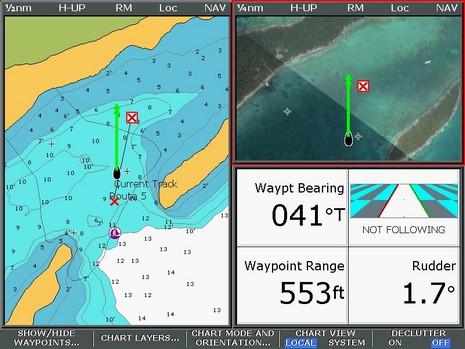
Note too that I have the photo map overlay at 100%, which best shows off their detail but also—egad!—obscures all spot soundings and bathy lines. I know old salts will howl, but I see the day coming when many will decide that eyeballing that data is a waste of brain cycles compared to, say, a “depth plane” feature or Garmin’s “hot colors”. Of course there are other ways to skin that cat, like the Bahamas screen below (full size here), where I’ve set up both a 100% chart window and a 100% photo map window. Not to mention a data panel, a great E/C feature introduced in 2006, and now improved with at least that mini waypoint highway choice (which only stopped working during the screen shot), and maybe more? And check out all the bottom detail on the chart, a vast improvement over previous Navionics Bahamas data and possibly the best there is, as they did their own surveying in some locals.
But this image turned out to be bitter sweet, and also a reminder of why I want easily accessed date (and source) info on cartography like this. You see back in the early 70’s I spent a couple of blissful weeks anchored here, working on the boat, diving for conch and fish, and wandering the long abandoned estate. What I remember most vividly was an old billiard house, overgrown concrete paths alive with cute lizards, and tiny sour oranges perfect for rum drinks. But now, though not yet visible on Platinum+, the lux vacation sales guys, and their dozers, have arrived. Damn!
I note your delicate treatment of two much abused (and justly deserving) manufacturers. But no matter how enticing the product may be, "buy it now and reset a lot" is a trademarked advertising slogan for a much larger software company. It occurs to me that your stretegy is to present these faults in a rose-colored light, maintaining friendly relations with the wounded bear, and to let us shred the still living remains in the most satisfying manner. Lets see how many ways we can say "I think I'll wait on this one!"