
Winter waypoint maintenance, tips from C-Map

Sort of like repairing or upgrading old instruments, you could also spend some winter off water time getting your waypoints and routes in order. C-Map has put together a nice tip sheet on how you might do that using their chart cards along with the nifty PC Planner product that lets you bring home plotter data and work with it and your C-Map charts on your computer. (To get the PDF, click on the orange card reader here.) You may not be up for making “chart art”, like above, but doesn’t it make sense to sort through the waypoints, tracks, and routes you accumulated last season?
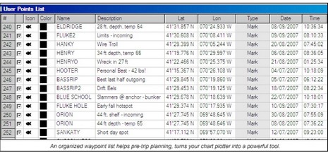
Fisherman especially might want to annotate (like below) and backup those hot spots before the memories fade. Me, I like keeping my tracks as a visual diary (and I’ve had pretty good luck moving them from one format to another). I’ve seen with several plotters I’ve tried recently that C-Map user cards and PC Planner work quite smoothly these days. But I have not tried the most recent edition of Navionics’ NavPlanner, which was a bit cranky in its early days. I also haven’t really tried working on a PC with data from the various new Garmins still in the lab, but I’m pretty sure that there’s no way I can use even the G2 Vision chart cards on a PC, and certainly not the charts build into the units. I think Garmin’s idea is that users can work with their waypoint, etc. data on other map formats, like Google Earth or NOAA raster charts. Has anyone worked out a good system for doing that?
I recommend and use either GPX or KML (Google Earth) format. Most nav apps these days support import/export of both formats. Both are extensible XML.