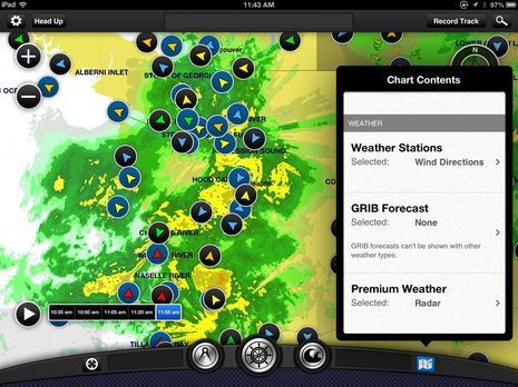
As mentioned yesterday, there was significant news today regarding Garmin's BlueChart Mobile app. In fact, anyone with a relatively current iPad, iPod Touch, or iPhone -- that is, one that's running iOS 6 or better -- can download the basic and free BlueChart app right now. And I think you should because I suspect that the app has value even if you don't go on to buy detailed charts ($30 for U.S. coastal) or the extra NEXRAD weather data (at just $4 it's nearly a no-brainer). But I say "suspect" because when I tested BCM after the Lauderdale show, the loaner iPad3 was already fully loaded with charts and Premium Weather. But I sure saw a lot to like...
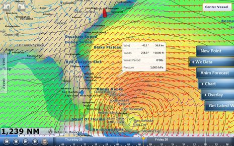
I first learned about Hurricane Sandy in an interesting way. While enjoying sunset in the Calabash River anchorage a week ago today, I was also fooling with various WiFi features built into a just-installed Furuno NavNet TZT14. Actually I was trouble shooting the seemingly flaky WiFi connection when I discovered that the TZT could connect to my Android phone's WiFi hotspot and even use that connection to quickly download a GRIB weather file. I've never seen an MFD do that before! Then I was admiring the TZT's neat controls for viewing the GRIB predictions -- like the intuitive way you can slide your finger along the forecast time bar seen at the screen's bottom -- when I noticed the tropical cyclone headed my way! But I lucked out; Sandy just slapped the Fort Lauderdale boat show around a bit, and now I'm aboard Gizmo is in a hurricane hole that's below the immense storm anyway. Today I'll be thinking particularly about other cruisers who didn't get this far south already, but I do have time to describe how Furuno is trying to do MFD WiFi different...
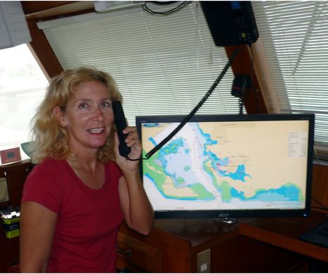
Panbo thanks Bob Ebaugh for taking some time out from a Caribbean cruise to write this review detailing his experience with several satellite phones, particularly an Inmarsat model built by Beam for fixed marine installation:
Early this year one of Ben's industry friends was interested
in an evaluation of a Beam
Oceana 800. I was in the right
place at the right time, and thanks to the kindness of Satellite Phone Solutions,
one was loaned to me for the season as I travelled from St. Martin to Grenada. We already had an IsatPhone Pro and Globalstar
handheld on board, so I can make some comparisons between the 3 different
products for voice and data communications.
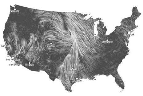
It's a beautiful data graphic even as a static screenshot, but you must check out Hint.fm's live Wind Map. Is it just me or is Wind Map the best presentation of macro wind direction and speed ever? It let me almost feel what that big low over the upper Midwest was doing yesterday, and if I was teaching weather I'll bet this is a live graphic that would help students truly get it. And while the two talents behind Hint.fm may characterize Wind Map as "a personal art project" I can't help but wonder how this presentation style and data source might benefit boaters...
Of course I admire another boating writer willing to put weird things on his head for the sake of research and a little levity. But consider me dubious regarding the anti-seasickness goggles Charlie Doane modeled aboard a yacht he almost crewed aboard for the Carib 1500 rally. The rally -- which runs from Hampton, Virginia, to the Virgin Islands -- got delayed by what became tropical storm Sean, and Charlie had to bail, but he still came up with an interesting story about the rally organizers and weather routers who try to help passage makers in this difficult season...
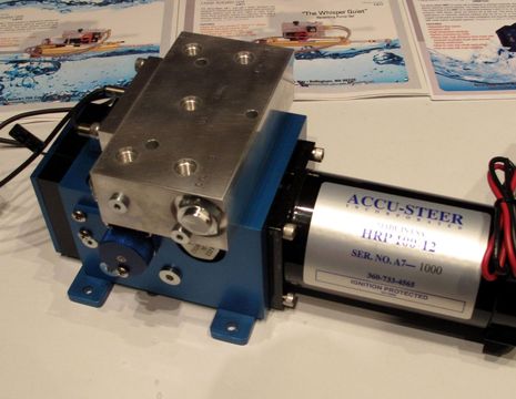
Yes that's an Accu-Steer reversing hydraulic pump meant to push a rudder around, but that block on top is a patent-pending sensor co-developed with FurunoUSA, and the whole package leads to the very interesting "Safe Helm" and "Power Steer" features coming to the latter's NavPilot 700 (which explains why the pilot came out elsewhere earlier). Safe Helm sounds a lot like the "Shadow Drive" feature so far only seen on the Garmin GHP 10 pilot for hydraulic steering systems; instead of poking a StandBy button, you simply turn the wheel to disengage the pilot and steer around an issue, then let the boat settle on a course again to re-engage. It's elegantly simple (I've tried the Garmin version), and it's potentially great that it's is no longer exclusive to one manufacturer. And apparently Furuno's unique method also means that the pump can be used to power assist a steering system, with numerous controls for how that's done -- like variable assist at different speeds -- built into the NavPilot 700...
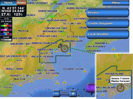
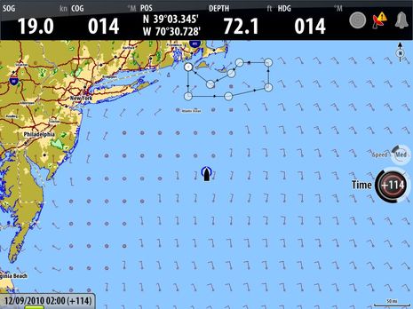
An energetic but somewhat chaotic frontal system passed over Maine last Thursday afternoon but I was able to keep on boating largely thanks to Garmin's new GDL 40 cellular weather system, which I'm getting to test somewhat ahead of the shipping date. The severe thunderstorm warning that headlined most of the NOAA coastal forecasts might have kept some people off the water. (The forecast areas greyed out on the screen above all have some sort of warning, as shown in the inset, as well as the full text, which can be called up.) But the animated Nexrad precipitation radar, along with lightning strike data, indicated that that my bit of Bay was going to enjoy a frontal hole...
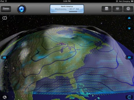
When I wrote about Garmin's new GDL 40 cellular weather system recently, the comments reminded me about how many different ways there are to access data and forecasts (and how opinionated some folks are about the methods they favor). So I guess I shouldn't be surprised when two apps that both specialize in downloading and displaying GRIB weather model data on iPads, or their smaller siblings, take quite different approaches to the task...
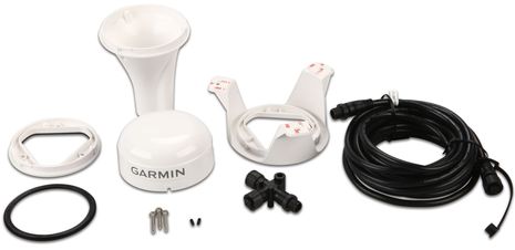
Yes, the hardware kit looks just like a Garmin 17x GPS or GXM 51 Satellite Weather rig -- what with three different install options, under deck included, and an N2K cable and tee for power and data -- but in fact it's the company's brand new GDL 40 Cellular Marine Weather Receiver, just announced today and shipping in June. I think it will be an attractive new integrated weather option because the hardware is reasonable at $300 retail and you only pay for the weather data -- available to start along the coasts of the U.S., Canada or Europe -- when you use it. But when you think about what other services could be provided by a two-way GSM cellular modem networked to your boat's NMEA 2000 network and (Garmin) MFDs, I think you'll agree that this may be one of the most important product advances of the year...
Though it's not mentioned anywhere, there's no question that B&G's new Zeus multifunction displays are re-branded Simrad NSE MFDs, with some special software sauce on top. But that's a good idea. NSE has a lot going for it, and the more ways Navico finds to expand its scope -- like the Simrad NSO system, also "soft launched" in Newport last week -- the better for everyone, I think. Besides, has there ever been an MFD that can do jobs sailors usually use PCs for -- like animating GRIB weather files, displaying data strip charts, and calculating laylines?