Saildocs is the baby of West Coast weather guru Jim Corenman, who with the support of SailMail provides a free e-mail server able to feed low bandwidth weather data (and more) to boaters. While not as pretty as the free, but limited Grib.us {or similar PassageWeather}, or the costly but widely used OCENS WeatherNet {or ClearPoint}, it provides a multitude of weather data in many formats right to your in-box for free. All of the Saildocs instructions can be retrieved by e-mail ([email protected]) or from their not-really-meant-for-surfing Web site. Below are my brief tips and tricks to using Saildocs:
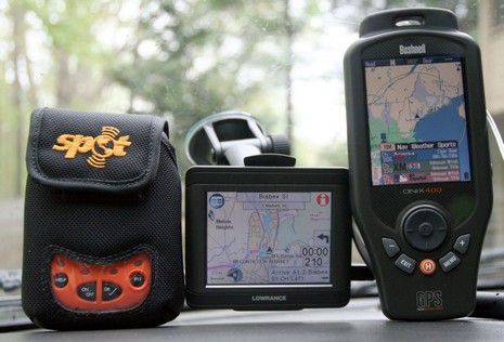
The electronics road trip was a blast, and it seemed appropriate that I drove it with three (3!) modes of satellite communications on my dash board, bigger image here.
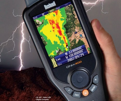
It took a while to get real, but just this morning I received assurance that I’m the list to try one of these intriguing Bushnell ONIX400 handheld plotters capable of receiving XM Satellite Weather and Audio (once they can get ahead of orders and free some units up for the media). It may be oriented to hunters, but couldn’t it be useful to boaters who want a relatively economical way to carry live satellite weather wherever they go? And, besides, how hard would be to add charts to a handheld that can already do topo and photo maps?
A great tip from Panbo reader Russell D.: The Space Science and Engineering Center (SSEC) at the University of Wisconsin offers a freePAW (PDA Animated Weather) service that looks like it would work well on Web enabled PDAs and Smartphones (also as a Google Gadget). That animation above is the New England Regional 15 Minute image and it even shows something called NSSL Forecast Radar, i.e. a computer guesstimate of where the precip will be in an hour (I grabbed the image at about 11pm). I’ve heard of this technology, but this is the first time I’ve seen it. PAW covers most of the U.S., often in metro detail, and a scattering of foreign locations. The data for any given place varies, often in interesting ways (research center!). Like check out New Zealand with jet stream and radar. Unfortunately I’m only peeping at this on the Web. You readers able to try PAW with something mobile…please report back. Thanks Russell! Oh, and if this pushes your button, also check out Memory Map’s Weather Radar, which may well be a more consistent, and data efficient, resource.
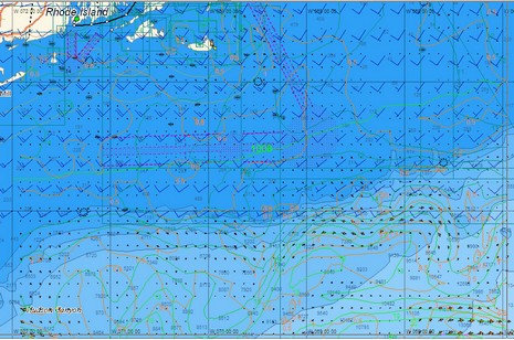
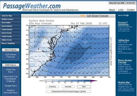
PassageWeather.com is apparently brand new, but impressive, offering free 7-day sailing forecasts for all oceans, updated 4 times a day. The interface seems clean and fast, data sources are explained, and you can download forecast charts easily. The region organization is nice too, and note that the ocean race routes are always forecast, so you can, as above, quickly see that heading, say, Norfolk to Bermuda today could be one fast passage, in the right boat. PassageWeather is no where near as ambitious as ClearPoint, but it seems well done. Your thoughts?
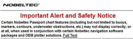
Yike. It seems that Nobeltec has guaranteed its support staff a busy holiday season by issuing the ominous sounding alert above along with update 9.3.2240 to its VNS and Admiral charting software. The exact chart regions/software combinations that have the problem are listed in the bulletin, and include the Northstar 972 but not the Simrad GB60. The good news for anyone who has trouble with the update is that Nobeltec recently extended its support lines to 13 hours a day during the week and 10 hours a day on weekends. The bad news for some is that with this update Nobeltec removes the ability to import S57 vector charts—for most people that means the free ENCs offered by NOAA—and even disables those already imported.
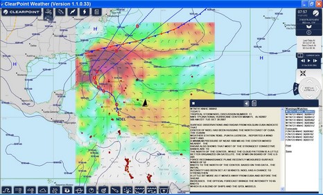
I’ve been trying ClearPoint High Definition Weather for a couple of weeks now, plus I talked to some of the team at FLIBS. This is a very ambitious operation. The ClearPoint goal is to provide the richness and simplicity of dedicated XM and Sirius satellite weather anywhere on the globe, delivered by Internet. Plus they’re aiming to provide more exotic data—like 1 kilometer wind forecasting of certain sail racing hot spots and game fish revealing altimetry/chlorophyll imagery—for certain niche marine markets. And they seem to be working with numerous nav software/hardware developers to provide integrated packages, even automated weather routing. At any rate, check out the full size screen shot of ClearPoint’s PC client software above. The icons at the top—wind, fronts, lightning, hurricanes, and text forecasts—show what I’ve chosen to display on screen. With the window lower right I can page through those various elements, clicking for specific places on screen. And the icons below show other data types I could add to my mix. I like the interface quite a lot and some of the data, like far offshore lightning, I’ve never seen in any weather product before. But buying the ClearPoint service is not trivial, and that does not include the cost of offshore downloads, which could be in the .5 meg per hour range (there is a low bandwidth mode, and ClearPoint is working on total download size controls). Interested? There is a free trial; please report back!
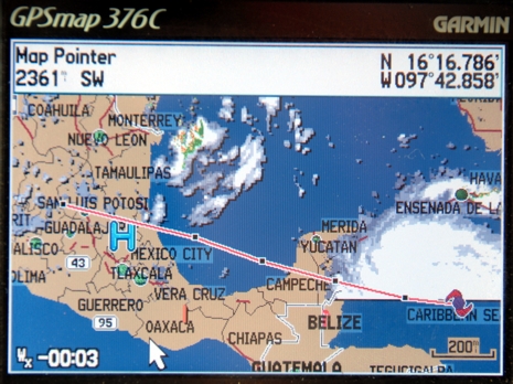
Panbot Allan Seymour (thanks!) sent in this image of Hurricane Dean showing on his XM-enabled Garmin. It also happens to show the southern limit of XM’s cloud coverage coverage. Which shouldn’t be confused with the southern limit of the area covered by XM’s satellite, though it’s close. Meanwhile, gCaptain put up a good list of online hurricane tracking maps, plus a link to great info on Google Earth storm tracking. Tis the season.
When I first mentioned the USCG’s need to replace its HF weather radios, I had a hard time getting into the Document Management System (DMS) where any us can make a comment or see other people’s comments. Well, apparently some 900 folks did figure out DMS, and the vast majority of them are asking the government to spent the four million dollars it will take to replace 20 transmitters. I learned this from Joe Hersey’s rec.boats.electronics post and there’s also a new NavCen page on the subject. There are 10 more days to make comments, and the USCG would like more, but neither of those references tell you how to find your way around http://dms.dot.gov/. The magic Docket ID/Number is 27656. Entering that in “Simple Search” or “Comment/Submissions” will get you to the HF Weather issue. Yes, it seems a little nuts that the government is going to all this trouble about a piddly 4 million (especially considering Iraq), but wouldn’t it be a shame to lose HF weather broadcasts?
Pardon a slightly meta sidetrack, but two bits of the massive media flow got my attention. One is a Wired article about Google Earth which makes the case that the future of cartography is user data. “We're all mapmakers now, which means geography has entered the complex free-for-all of the information age, where ever-more-sophisticated technology is better able to reflect the world's rich, chaotic complexity.” Then there’s the news that scientists have calculated that the diameter of the globe is about 5 millimeters less than thought. Not even a quarter of an inch! Among other techniques, they used atomic clocks, quasars, and 70 radio telescopes to establish base lines, and they say that the precision they are after will help to better measure phenomenon like global warming, ocean currents, and tides. As amazed as most of are by all the information now available on a yacht’s bridge, I think we’ve just gotten started. (For some really interesting dope about related planet dimensions, and early cartography, check the beginning chapters of Nigel Calder’s How to read a nautical chart, which also has practical uses!)
PS 7/12: It turns out that Captain Richard Rodriguez, who has a thing or two to say about the Boston ferry collision (see his fine blog), has also used Google Maps to mark the most frequently hit rocks in the San Juan Islands. What I’m talking about!


 When I