I was a little stunned this morning to discover two very interesting and ambitious marine weather services that seem to have sprung up fully formed, but without my knowledge! SailFlow and FishWeather are sister services, each offering tailored weather products either graphically via the Web or a WAP enabled cell phone (there are lots), or via a regular voice call. The services boast their own weather sensors covering a lot of the U.S. coastline, plus their own meteorologists and even computer modeling programs (in addition to public resources, of course). It turns out that both are the spawn of WeatherFlow, a company which has spent 15 years building a “national coastal mesonet with a presence in over 20 states…The WeatherFlow staff of engineers, meteorologists, and IT professionals are dedicated to increasing the understanding of the complex nature of climate within the coastal zone.” I intend to try out at least each service’s free month trial Web subscription. By the way, Eli of EliBoat—whom I had the pleasure of meeting last week—has been using WSI live satellite weather, which is a whole other animal than SailFlow. He posted some comments yesterday.
I missed the fact that WSI, the company behind Weather Channel Marine, inked a deal with Sirius Satellite Radio in March. "Our goal is to offer the gold standard of marine services”. This is good news, as it should heat up the competition between WSI’s service, now only available on PCs (including Maptech i3) via a single satellite, and the XM Marine Weather that can be had either on a PC or on Garmin network plotters. I’ve been watching the “live” weather category closely, and have tried at least the early PC and Garmin products, and was very impressed with how much detailed and macro weather sense I could get easily. In fact—odd timing—I was trying out a pretty good GRIB weather tool last night, but without the Nexrad radar and frontal line predictions, I missed the wet squall line that’s passing through here this morning! Above, and bigger here, is part of an old Weather Channel Marine screen that just suggests how you can see animated Nexrad combined with current and forecast fronts…very effective. A face off between giants Sirius and XM as providers of top notch U.S. coastal marine weather should lower subscription and hardware costs, open up new platforms, and really make boaters aware of this valuable service.
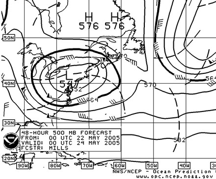
Yike! Above is the OPC’s prediction for 8 pm tomorrow night, my time. Today, 20 of the mightiest sailing yachts on the planet will set off from New York in a Transatlantic Challenge meant to celebrate, and smash, the 12 day, 4 hour race record set by Charlie Barr 100 years ago (also well explained by Josh Adams here). Somewhere the famously hard-driving skipper may be chuckling. If I’d been invited to join the fascinating mix of swells, enthusiasts, and pros (some apparently obnoxious) making the crossing, I’d be feeling a bit like a squirrel in front of a truck. That low looks like a lot more weather than is normal this time of year. I’ll bet the onboard weather guys and routers like Commander’s are quite focused right now. It seems like communications and forecasting technology will play a big role in whether these boats get a sleigh ride or a pounding. I’ll be following the race with interest this week (and hoping to learn more about the electronics used).
Monday, 11 am update: the Grand Prix boats have headed way south and are now making 18 knots. Meanwhile the big low may stall right over Cape Cod, which is where I was supposed to go boating later this week. Drat!
Tuesday, 12 am update: the gale warnings here in Maine and on the Cape have been upgraded to storm warnings, NE gusts up to 50k tonight, but it’s still not clear how the racers will fare, though the ones who went way south are looking pretty smart right now.
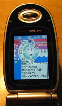
Another item in the May PMY is my test of WeatherWave, a neat service that delivers NOAA alerts to your cell phone and also lets you dial up specific forecasts and buoy reports. I note that it will work on any phone because its servers convert NOAA text to voice. That’s in contrast to Ekkosoft’s MarineWeather, another clever service that translates NOAA alerts and forecasts into informative graphics (right). You do need to be using Verizon Wireless on a handset that supports “Get It Now” applications, but I was very impressed with the results when I tried it. Both services can get a boater just what they need from NOAA’s vast weather resources…without having to wait through a long and tedious VHF loop.
The evidence is piling up, so to speak. Last night I spoke with a friend anchored off Key West who said he and his very able 53’ trawler were delayed there by heavy seas. Now I’m listening to a guy on CNN describing how his cruise ship honeymoon in the Bahamas got messed up (the on deck Jacuzzis got washed away, amongst other problems), and the damage done to another ship off Georgia is all over the news. “When the wave passed -- some estimates have it higher than 60 feet -- two windows on decks nine and 10 of the 15-story ship were blown out, 62 cabins sustained water damage and four people were treated for cuts and bruises aboard the ship.”
I went over to NOAA’s Ocean Prediction Center to see what happened (above), and discovered that the site now has a nice “looping” function for reviewing forecast and analysis graphics.
Writing the entry below I realized that there doesn’t seem to be a picture of the sailboat WeatherStation model on the Web, and there should be! Astute observers will note that a French company, LCJ Capteurs, has offered a CV3F ultrasonic wind sensor for some time. In fact, Airmar licensed this solid-state design, and then reportedly improved it—adding a little heater to protect against extreme ice/snow interference and an inclinometer to correct for heeling errors. The developers at Airmar also threw in a fluxgate compass for true wind direction calculation, and even an LED lit Windex indicator for sailors who like to sometimes look aloft instead of at a screen (and/or like having a non electronic back up). The WeatherStation, which will cost about $1,000, can also sense air temperature, barometric pressure, and more, and can supposedly collect some history on its own. The intriguing device manages to squeeze all this info into one cable and the NMEA 0183 protocol, but a coming NMEA 2000 model will be better at data distribution. No instrument or display manufacturer has yet announced a product that will make the most of this sensor, but no doubt several are working on it. Airmar has not posted any product specs on its site yet, or I couldn’t find it!

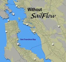 I was a little stunned this morning to discover two very interesting and ambitious marine weather services that seem to have sprung up fully formed, but without my knowledge! SailFlow and FishWeather are sister services, each offering tailored weather products either graphically via the Web or a WAP enabled cell phone (there are lots), or via a regular voice call. The services boast their own weather sensors covering a lot of the U.S. coastline, plus their own meteorologists and even computer modeling programs (in addition to public resources, of course). It turns out that both are the spawn of WeatherFlow, a company which has spent 15 years building a “national coastal mesonet with a presence in over 20 states…The WeatherFlow staff of engineers, meteorologists, and IT professionals are dedicated to increasing the understanding of the complex nature of climate within the coastal zone.” I intend to try out at least each service’s free month trial Web subscription. By the way, Eli of EliBoat—whom I had the pleasure of meeting last week—has been using WSI live satellite weather, which is a whole other animal than SailFlow. He posted some comments yesterday.
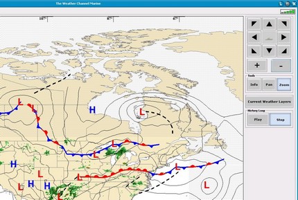
 Another item in the May PMY is my
 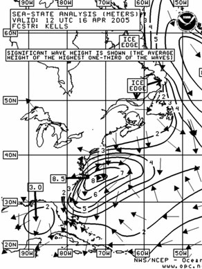 The evidence is piling up, so to speak. Last night I spoke with a friend anchored off Key West who said he and his very able 53’ trawler were delayed there by heavy seas. Now I’m listening to a guy on CNN describing how his cruise ship honeymoon in the Bahamas got messed up (the on deck Jacuzzis got washed away, amongst other problems), and the damage done to another ship off Georgia is all over the
 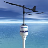 Writing the entry