It is disconcerting when all the waterfront owners within a few hundred feet of your boat remove their floating docks for fear of hurricane damage! In fact, the harbors in my area were jumping on Thursday and Friday; lots of boats got hauled, and the rest of us hunkered down with chafing gear and extra lines applied, sails and biminis removed or trussed up, etc. etc. But Hurricane Earl lost its steam, big time. Even the Friday 6 pm forecast by our most reliable local source, Locus Weather, turned out to be way off the mark; instead of the predicted late night easterlies of 30-35 knots with gusts over 40, the GoMOOS F01 weather buoy recorded a max hourly average 14k with a max gust of 17. I slept aboard Gizmo like a baby...
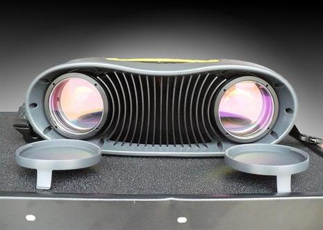
Are you able to estimate wind direction and speed from small waves in the water, the movement of clouds, or visual cues from other boats 300, 500, or even 700 meters away? It is a good skill for a sailor to have, but very tough to learn. The Racer's Edge, pictured above, is a high tech wind measurement device capable of measuring wind speed and direction at considerable distances, enabling a sailboat crew to optimize course and sail trim for maximum speed.
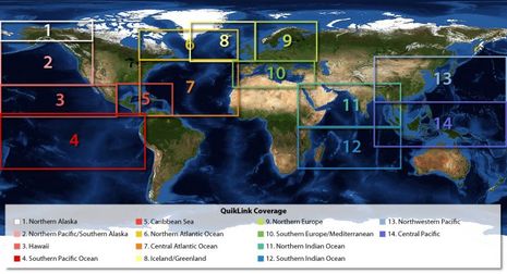
XM Satellite Weather actually has nothing to do with this new product, but I mention it in the title because Baron Services is both the meteorological expertise behind XM Weather and the developers of the WxWorx software which can make that XM data accessible on a boat's PC. The idea of the new Quicklink is to provide XM-WxWorx-like semi-real-time weather beyond the North America coverage area of XM's satellites, and it looks like Baron is pulling a couple of rabbits out of the hat to do it...
Here I am trying to cover the world of marine electronics from my nest in Camden, Maine, and darned if I don't miss interesting happenings in my own neighborhood. Apparently Richard Baldwin, an experienced bluewater solo sailor who lives just up the Bay in Belfast, is the passion and brains behind an unique endeavor that's using mini sailing drones like the prototype above to teach students of all ages about oceanography, not to mention GPS and satellite communications...
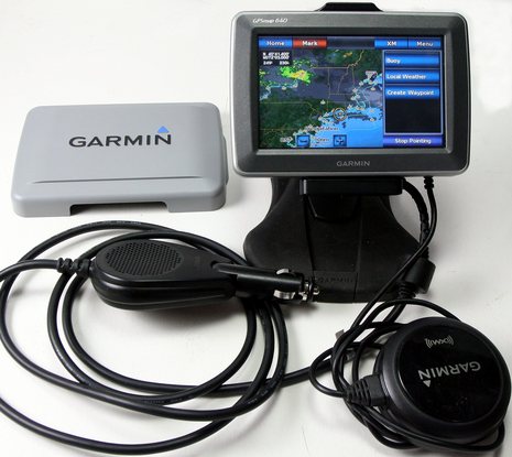
One gizmo that's definitely coming along on the Gizmo delivery is this Garmin 640 beta unit. In nüvi mode it can navigate the highways down to Connecticut, as it's done well twice already, and I can then reboot it into marine mode for the voyage home, with XM audio and weather available all the while. The marine satellite weather presentation seems particularly good, as you can see somewhat if you click on the screen above; it's set up so that the Nexrad radar and cloud cover are animated and a finger tap leads to a choice of local forecasts, buoy data, and more, depending where you tap. But finding a good place for this 18 ounce "portable" on your dash or at your helm may not be easy...
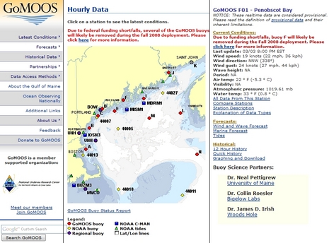
GoMOOS sounds like some sort of Maine college cheer, but is actually the Gulf of Maine Ocean Observing System, a nonprofit I appreciate for many reasons, but most especially its Penobscot Bay Weather Buoy F01. I love Buoy F. Whenever I want, it offers me near real time wind, sea, current, temperature, and even visibility conditions, plus trends for each over the preceeding hours. Which I use to reality check the current marine weather forecasts, and thus often make better informed decisions about what sort of boating I can do. Meanwhile GoMOOS data is helping to improve the weather prediction models, and advancing ocean science in many other ways. Good sensors are so important. Just like on a boat, the fancy screens (or fancy forecast graphics) don't mean much without accurate data feeds. So why the hell are GoMOOS and other regional weather buoys are getting pulled for lack of (fairly trivial) maintenance funds? And would you believe that I came across a pretty good answer on the Comedy Channel?
Either XM or Sirius Weather and Audio is now available on nearly all major MFD brands. Above is Sirius seen on the new Lowrance HDS during the Broadband Radar demos. The implementation looked very good (as did the whole HDS package, more on that soon), but in truth all the satellite weather implementations seem to be getting better. I spoke with both XM and Sirius representatives at the Boat Show and their message was that they really are working together now--they are just two divisions of the same company--and that they weren't too worried about the wild battle of the media moguls that had put their company high on the business news page...
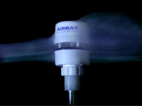
PB200 with VHF extension pole for mounting atop a masthead
I am writing to share my excitement about a new product from Airmar, tested aboard my 39 foot sailboat this past October-November. The Airmar PB200 is a compact masthead sensor that includes an ultrasonic (no moving parts) wind sensor, solid state compass, GPS receiver and more, along with a 3-axis accelerometer. It has an NMEA-0183 output that I found compatible with my Raymarine instrument suite. Airmar doesn't market this for use on a sailboat, but when I learned about the new version of this powerboat product, I got excited about the potential to make my autopilot much more useful when sailing short-handed. Thanks in part to Panbo, I got the opportunity to evaluate a beta version on my own sailboat...
How behind is Panbo? Well, in July I whined about Garmin’s introduction of the touchscreen Oregon handheld before I’d yet written much about the somewhat similar Colorado. While I’ve been testing an Oregon for some weeks (and still haven’t posted here about it), Garmin has introduced two new handheld/portable units of considerable interest to boaters. One is the nüvi 500 above, a waterproof, multi-mode version of Garmin’s 3.5” touchscreen automobile navigator. Which makes it a direct, and probably awesome, competitor to the Lowrance XOG and Magellan Crossover. Fortunately, the able blogsters at GPS Magazine and GPSTracklog have both reviewed the unit, though neither went boating with one. I don’t think anyone has yet seen the intriguing GPSMap 640…
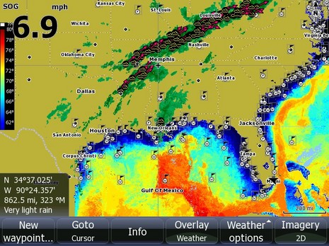
Check out the bigger image. That’s a new XM Satellite weather service called NavWeather that’s going to debut on a lot of Humminbird multifunction displays next January. I don’t fully understand what makes it different from the XM Satellite Weather many of us have seen on Garmin MFDs but there are some clues. The brief demo I saw and photographed at MAATS, for instance, shows NexRad radar with lightning and at least a bit of animation…which I think of as the most important elements of a live weather feed. Yet NavWeather is considerably less expensive than the current service, $10 a month with $15 activation fee and a $250 receiver. It also uses something the press release calls “Threat Matrix technology to track nationwide weather information for more than 20 different weather conditions,” and deliver appropriate alerts.