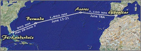
I’m way behind on work, not to mention the gizmo preparation, that needs doing before Bermuda (wow, Bill and Gram were fifth over the line and third in class corrected), so I’m turning it over to Milt Baker. These snippets are from today’s noon report, filed from almost the midpoint of the Med Bound 2007 Bermuda-Azores leg:
Ships are few and far between out here. We nearly always pick them up on AIS before seeing them on radar. Moana Kuewa (which has the same Furuno FA-150 AIS unit we have) clearly has the best installation {not trivial} and picks up the ships first every time, sometimes as much as 20-30 minutes before they show up on the AIS units aboard Salty Dawg and Bluewater.
1. Apparently the HF transmitters the USCG uses to send out offshore weather forecasts—voice, fax, etc.—need to be replaced and the government wants to know if it’s worth the money. If you use SSB or HAM for NOAA weather, or ever plan to, you might want to look here for ways to speak up. (I managed to find the electronic comments the other day at http://dms.dot.gov/, but can’t get there today).
2. Yesterday the FCC issued a request for comments regarding the granting of waivers so that USCG approved Class B AIS transponders can be used in the U.S. while the Agency works on a final rule making. The FCC’s online search and comment software is also clunky, but try going here to make comments, and look here to review them (nothing so far, but some interesting older stuff, like Orbcomm’s interest in providing satellite AIS tracking). In both cases use Proceeding # “04-344”.
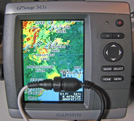
I’ve got the new Garmin GXM 31 hooked up to the 545s, and am once again impressed with how deep this “product line refresh” really went. I’ve tested Garmin XM weather on several devices over the years, and saw the interface get better and better. But they threw a lot of it away in favor of an easier, if less tweakable, presentation. For instance, the only control you have over the main chart overlay above is weather on/off, Nexrad animation on/off, and legend on/off. But the data selection is good (yes it rained shortly after that photo), and for more weather you go to the main Information menu where you’ll find a selection of weather presets, each modestly tweakable from the menu key. I didn’t have the manual at first, but pretty much figured out all the possibilties on my own.
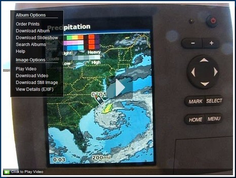
I’ve been feeling mighty guilty about my oh-so-slow testing of the borrowed Garmin 545. So it was particularly great to find that a fisherman named Tom has posted a useful series of stills and videos illustrating many 545 features. His Bluewaterpirates Phanfare album may be called “XM Music Functionality” but you’ll find dope on the new Vision charts plus a nice “new section” showing all the XM weather functions using a dramatic offshore low, and more. Enjoy.
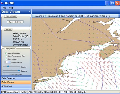
In Maine speak, that low pressure system which blasted through here last night was a “corker”, leaving at least 10” of snow which has a gluey consistency unfriendly to snow blowers and plows. Panbo world headquarters is still digging out! Now, of possibly greater interest, that screen above is from a new and quite nicely done weather program called UGRIB. It lets you download and display forecasts for any section of earth as generated by NOAA’s “global numerical weather prediction model.” And it’s all for free, thanks to the folks at GRIB.US. You only get wind, pressure, and precipitation—and, of course, you can find far richer weather data on the Web—but one beauty of GRIB files is their compactness if your data pipe is limited…like, say, a sat phone out in the ocean. GRIB numerical data can also be animated, as UGRIB does, and used by routing programs. Meanwhile, back here in Maine, a 40’ scallop boat sank Tuesday night as it tried to return home ahead of this storm. The crew is fine, apparently because they were well equipped with EPIRBs, survival suits, etc. The Luke & Jodi even had some sort of transponder such that the owner could track it from home, though that let to some confusion. At any rate, the crew did everything right according to the Coast Guard, except perhaps deciding to supply the liferaft with a case of beer and bottle of vodka “to keep them occupied while they waited to be rescued.” That led to problems (and more detail here).
It’s not every day that the New York Times puts a tech merger on the top of the front page, but amazingly the XM/Sirius merger, rumored for ages, never came up (around me) in Miami…despite lots of news about their competing marine weather services. Northstar, for instance, previewed its 6100i Sirius Weather product, which makes terrific use of softkeys to mix and view all those data elements (a real challenge). For instance, that “Overlay” key above (bigger here) let’s you page through six different customizable data mix presets, each represented in the little window with icons, and you can further tweak the data presentation by setting ranges if you want. Furuno was also previewing a Sirius weather product (PDF brochure); the interface seemed much more rudimentary, but since Furuno is using a new generic Sirius receiver (Northstar’s is their own) and there’s also new Sirius weather PC software in the works, a boat might be able to use both on the same subscription. Sirius Weather was also showing on a Maptech i3, which already runs XM, and as part of a ambitious new SkyMate product that includes GPRS and Orbcomm communications. And Raymarine introduced Sirius Weather for the C-Series, which incorporates a cool implimentation of Sirius audio, including volumn control, easy presets, notification of favorite artist and some other subtleties. Audio is already built into the E-Series Sirius receiver—all these receivers, in fact—but the audio interface won’t come for a while.
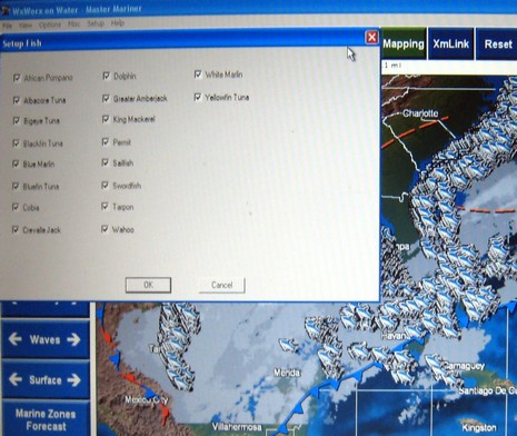
Meanwhile, XM’s big news is species-specific fish finding data (sorry for poor pic below), as well as extended wave, wind, and surface pressure forecasts and more Canadian data, including radar (Puerto Rico too)—all included in the same $50/month Master Mariner subscription—plus there’s some exciting new hardware and relationships in the works. In short, there’s a hell of a Sirius/XM competition going on just in this little marine weather segment. What does it mean if and when the two become one? Your thoughts please!
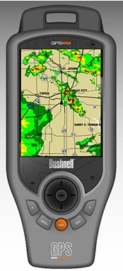
EliBoat made a good catch last week, spotting this Bushnell ONIX400CR GPS and XM handheld. The specs, as spied out by the sat radio blog Orbitcast, look impressive—waterproof, 3.5” screen, XM weather & audio, aerial and satellite photo overlays—and all supposedly retailing for $500 when the product ships in February. That’s a big discount from the Garmin handhelds that offer this same great ability to carry your XM subscriptions from boat to car to house, etc. Mind you that Bushnell shows no interest in the marine market; its thing is hunting, as shown by its Web write up for sister product ONIX200CR. Still, I want to try one and see if it might make sense, even without nautical charts, as a boating accessory. This product, by the way, is an ‘honoree’ in the Wireless Peripheral category of the 2007 CES Innovations Awards, always a geekerrific list.
More good news on the cost of marine electronics front: Navionics is apparently going from XL3 to XL9 Gold+ chart cards, three times the area for the same $200 price. That’s the whole East Coast and Northern Bahamas on one card, with full NOAA chart detail (unlike the Silver all-one-cards), plus “enhanced port services” POIs (flawed though everyone’s may be), coastal roads, and a mail-in coupon for a free Fish’n Chip bathy card. This price drop is not on Navionics’ Web site yet, and may not be effective until 2007, but Peter James of Jack Rabbit Marine has the scoop on his new blog, askjackrabbit.com. A blog by a guy who professionally installs marine electronics? Now there’s some really good news.
I’m still looking for more detail on this story—like how many buoys, and when?—but I understand that the U.S. Coast Guard and NOAA are working together to put AIS transponders on many of the offshore weather collecting buoys. Of course that means that the buoys will show up as targets. But also broadcast will be the sensor data—current, wind, visibility, etc—which will supposedly then get ashore (and into the satellite and other services) more frequently, plus be available direct to anyone with an AIS receiver and the right software. But that’s not the only purpose, by any means. The transponders are apparently set up to forward received target info via Iridium to the USCG Maritime Domain Awareness Program. Hence, “the buoys would form a ‘picket line’ around the continental and southern Alaska coast that would detect AIS-enabled ships as they pass in near real-time to enhance maritime security, as well as support safe marine transportation for commerce.” (Images graciously passed along by Fred Pot)
PS 8/8: I stand corrected: while the transponders described above are being “discussed”, what the USCG is actually working on right now is simply placing “AIS receive-only equipment on certain weather buoys in order to receive AIS signals from ships further offshore than can be done with shore-based receivers.”
Looking at the animated version of this graphic too long may make you ill, but it does nicely illustrate the very different schemes that Sirius and XM chose in their efforts to blanket North America in audio and data, including, of course, our recent obsession…live marine weather. Both schemes seem to work fine around the U.S., especially on boats with their naturally wide open sky views, but how far offshore, north, and south can you receive Sirius or XM? A lot of cruisers would like to know, but the company Web sites seem vague on the subject. For one thing, I don’t think they themselves are positive about their footprint edges, and don’t want to over promise. Another issue is that XM and Sirius may broadcast into countries where they are not licensed to, and where someone thinks they should be. You may recall a long period when Canadians could only subscribe to satellite radio using U.S. addresses, even though most could get it fine. XM and Sirius were not bragging about their Canadian coverage then! Both Audio services are now licensed in Canada but, head’s up, Sirius Weather isn’t yet. Which brings us to some legalese in the Raymarine Sirius literature suggesting that your expensive weather receiver might not work if you go outside U.S. territorial waters. Not true; I checked! And judging from the unofficial footprint map kicking around the Internet (right, and slightly bigger here), Sirius will deliver fine service in Canada, out past Bermuda, down to around Antigua, across to maybe the Canal, and actually further into Alaska than shown (so I’ve heard). I understand that XM is similar except that it doesn’t reach as far south, which seems confirmed by the unofficial XM footprint map below, created by WxWorx, the company that’s developed a PC hardware/software system for XM Weather. They’d like to hear more reports from XM users on the edge, and I’d like to hear from anyone who knows more about how far either service reaches. Thanks.
PS, 7/28: We’ve been kindly sent links to a good collection of footprint maps and to a related forum discussion in which one poster describes getting XM in the Azores using a dinky home antenna (though it was before some changes in XM’s satellites).
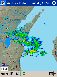
How about that! The Memory Map Nexrad function for Smart Phones that I tried and raved about now does animation, at right, plus it’s been debundled from the charting software. $10 and it’s yours, no subscription needed, and data use is efficient and user managable. (By the way, developer Richard Stephens may be seriously field testing this product over the weekend, as he again sails the Mackinac aboard Flight Simulator. He says the course is a thunderstorm alley. Good luck, Richard!)
Meanwhile, Panbo reader Bob Mueller wrote in to say that he’s figured out how to get simple Nexrad images onto his not-so-Smart Motorola v710: I host my own website on the residential DSL line in my home, and I created a page with a custom PHP script that I wrote. The PHP script goes to the ADDS (Aviation Digital Data Service) website, pulls a NEXRAD radar image for the area where I boat. The image displays a very large area, that would not be easy to interpret on my cell phone screen. My script then crops the image to the exact resolution of the phone screen. The script saves this cropped image to the hard drive on the web server for display on my cell phone's screen via the phone's web browser. (I would be more than happy to share the code, it is only a few lines!) {Send me a note if you want that code — Ben}.
PS Thanks to Gizmodo for picking up on my Sirius & XM weather testing (even if they somewhat misinterpreted my ramblings); we’re getting major hits, which I find very auspicious as today I officially became sole proprieter of www.Panbo.com. Wishing all a great weekend.


 EliBoat made a
  I’m still looking for more detail on this story—like how many buoys, and when?—but I understand that the U.S. Coast Guard and NOAA are working together to put AIS transponders on many of the offshore weather collecting buoys. Of course that means that the buoys will show up as targets. But also broadcast will be the sensor data—current, wind, visibility, etc—which will supposedly then get ashore (and into the
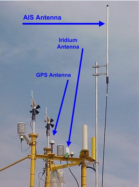
 Looking at the
  go outside U.S. territorial waters. Not true; I checked!
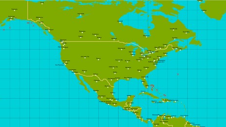
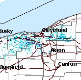 a page with a custom PHP script that I wrote. The PHP script goes to the ADDS (Aviation Digital Data Service) website, pulls a NEXRAD radar image for the area where I boat. The image displays a very large area, that would not be easy to interpret on my cell phone screen. My script then crops the image to the exact resolution of the phone screen. The script saves this cropped image to the hard drive on the web server for display on my cell phone's screen via the phone's web browser. (I would be more than happy to share the code, it is only a few lines!) {Send me a note if you want that code — Ben}.