I do feel a little guilty. My buddy Jamie was out there in those islands with friends and family on a Maine Cat 41, and I knew it, but didn’t think to call his cell and advise him about just where those monster thunderstorms were tracking Tuesday evening. Yeah, they’d heard the warnings beeping all over the radio, but still didn’t know if a cell would actually hit them, or when, until one rolled over the horizon (which surely happened, as shown so vividly above). Sorry, Jamie!
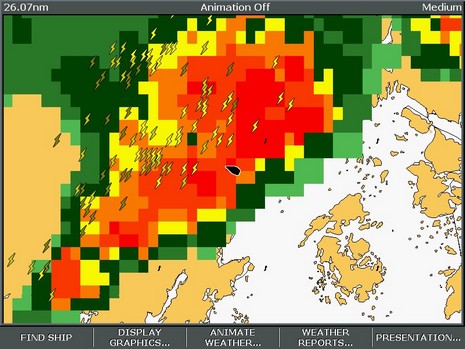
It was too bad because I could really see what was going on, having fired up both the Sirius and XM live weather services I’m testing. My goal was to see how detailed and accurate the satellite information is, and more specifically if it could have helped me get around the worst of the weather in a reasonably fast boat. Conclusion: Yes, if the cells aren’t coming at you in a solid line, and the boat is fast enough. Of course there are numerous subtle differences between the services, and a few anomalies. In the latter department, observe the two photos below, Garmin XM on top (bigger here), Raymarine Sirius below (bigger here), taken at almost exactly the same time.
For some reason Sirius was not tracking any storm cells in New England that evening, i.e. was not generating the arrows that indicate speed and direction, and can be clicked on to reveal more information like chance of hail. XM’s tracking, which nicely indicates the dimensions and speed of the cell, was working fine, but its analysis of precipitation seemed to be markedly off. I was there, and the rain was tapering off just as indicated by Sirius, not about to pour buckets as suggested by XM. Yes, XM shows a 4 minute delay, but I don’t think Sirius was much fresher (it should be time stamped). Hell, that data has to go from the radar station out to a network, through the processing facility, up to the satellites, and back down to these machines. A four minute delay is damn good, especially given this level of detail for the whole U.S.A. And that’s the real story here; I would really like one or the other of these services at my helm. More tomorrow.
7/21 Update: Sirius and data provider WSI are trying to figure out why those storm cells weren’t being tracked (I see a similar problem today off Long Island), and I have a call into XM about why their Nexrad might be a little off. In the meantime, a couple more notes to go with these illustrations:
* I like how Raymarine overlays the weather on a simple outline map, instead of charts, but it would be good to add some landmarks for orientation, like maybe port names. I found myself turning all sorts of stuff off on the Garmin charts, stuff I’d like to see otherwise, so I could see the weather better. On the other hand, the streets and names on the Garmin were useful when overlaying cloud cover, as seen above. Sirius does offer cloud cover, but does have Canadian weather radar.
* Garmin’s new “Presets” weather interface is excellent. See the “Storms” lower left on the screen; push the Next Preset soft key and you get the “General” preset, then the “Sea State” preset. The names don’t really matter as you can go into the weather setup area and customize just what mix of data you want for each preset. Moreover—and Garmin has had this for a while—you can specify presentation of individual data types by zoom level. That’s a little harder to get a grip on, but also helps you mix all the data available in sensible ways. I encourage Raymarine to steal the preset concept, and maybe the zoom level too, ASAP!
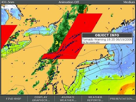
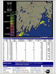
I looked forward to the battle of XM and Sirius marine weather services, and now it’s here. Right now, down in the shop, I’ve got Sirius Marine Weather running on the E-120 and XM Marine Weather running on the Garmin 3210 (and both are ready to go aboard Ralph, which I launched yesterday, yeee-ha). That screen shot above is Sirius on the E, bigger here. You’ll notice Nexrad precip radar, storm cell vectors, water temp, wind arrows, outlines for NOAA text forecasts, and of course the red Tornado Warning area. There’s a lot to these services, and to the interfaces needed to get the most from them. I’m wondering if any of you have experience with either service, or would like to see particular data screens, or just have opinions about subscription weather? Here’s a good page to see what XM beams down, and here’s a similar list for Sirius (click on the FAQ). Don’t be shy!
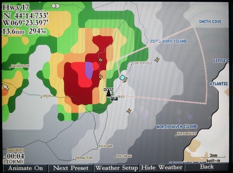
PS 7/13: An unusual aspect to the Sirius screenshot is that we almost never get Tornados in this part of the world, and it was nice to have a plotter beep me about the possibility. On the other hand, no tornados actually materialized (no fault of Sirius). Below, bigger here, is a Garmin XM image from last evening. That rain definitely did come my way.
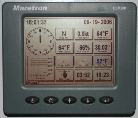
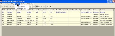
As you may have noticed from the antenna farm, I’m trying the Maretron Weather Station announced last fall. It’s hard to imagine an easier physical install…unscrew a T in the NMEA 2000 backbone, add new T and the WSO100 sensor, power and data done. The Raymarine E, plus RayTech 6.0 on the SeaTalk HS bus, immediately got the ultrasonic wind speed and direction data. Coastal Explorer got it too, as no doubt other PC programs would, via the Maretron USB Gateway (in other words converted into NMEA 0183 messages). Air temperature, barometric pressure, and relative humidity are a different story. There are NMEA 2000 and 0183 sentences for this data but so far nothing I have reads them all except Maretron’s own display. Obviously that’s also true for derived values like wind chill and dew point. At any rate, the display did need updating to understand the WSO100 and put up new screens like the one above, and Maretron has developed a nice program called NK2 Network Analyzer (below, and bigger here) that can update any device on the backbone. (PS: Just noticed that Maretron has put up a demonstration program).
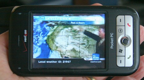
The impressiveness of the above, bigger here, was no doubt heightened by how BIG the weather was around Boston today. I was supposed to go boating on a 44’ Sea Ray but even a few hours tied up in a very protected marina felt heroic given the volume of wind and rain. The project was interesting and I’ll tell you about it tomorrow, but today I’ll just show you the wild and crazy phone one of the guys pulled out. That is the Weather Channel playing on that Verizon XV6700 and it looked and sounded quite good. I was tickled a few weeks ago just to see just static Nexrad on a phone; this TV feed included not just animated radar and sat imagery but a live forecaster (as long as high speed EvDO is available). And it’s source was not some Web site but rather the owner’s own home TV setup which is equipped with a Slingbox, able to serve whatever channels he already pays for out to the Web where he can watch them even when he’s not home, even when he’s rolling around on a boat. The software is SlingPlayer Mobile and apparently it can even control a Tivo type recorder. So beyond live Weather Channel are a lot of other intriguing possibilities.
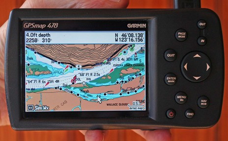
I suppose it was predictable, but it’s still amazing. The Garmin 478 above has all the XM Weather and Audio abilities that distinquished the 376C, and it comes loaded with all U.S. charts and all U.S. and Canada road maps. It’s fast too, even the ‘Find’ command is not slowed up by what must be a zillion POIs, nav aids, intersections, etc. stored somewhere in that little casing (and hence I’d bet that Garmin has sped up Find in the first all-U.S.-charts 192C I tested last summer).
Not that the 478 is perfect, even if there is nothing like it out there. For instance, these are the new G2 charts, but apparently the 478 will not be able to show the vaunted perspective view. I do gather from the spec page that it will show the photos available on G2 cards, and the screen above (bigger here) does look richer than regular BlueCharts. But, as good as this screen is, I find myself wanting to plug the 478 into a bigger monitor, maybe use a wireless keyboard and mouse with it too. The unit lets you use an expensive XM subscription anywhere you go but in some of those places, like a boat, you may want to expand the system. Just a thought, probably inspired by how rapidly this unit has evolved over the years.
I should also add that the Panbo reader who recently complained about the “Surface Wind” coming from XM to this machine was right; it’s old. He tells me that Garmin has acknowledged the problem and is working on it, but I also noticed this time around that you don’t get predicted wind and wave model data, something the new Sirius Marine Weather is very good at.
Garmin also announced a new pair of radar scanners this week, this time inside a smaller, 24” diameter casing, and with more emphasis on the digital processing going on in there. Finally, though Garmin hasn’t yet promoted it, many of its new plotters apparently do support AIS. The 478 is not one of them but I think I’ll soon get the chance to try it on a 3210.
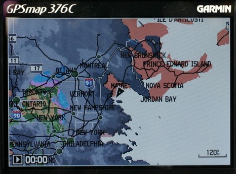
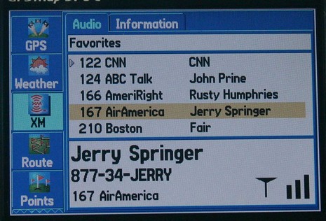
I would have posted earlier today, except that fooling with this Garmin 376C vividly reminded me (above, and bigger here) that the spell of dry, sunny weather was about to end. So I spent some hours winterizing the fleet, all the while watching the clouds thicken up from below and above. I could also see an animation of all that rain moving across New York state, plus the lightning strikes, the frontal lines, pressure gradients, wind predictions, buoy reports, etc. etc. It is phenomenal how well you can see all this info on the 376’s little screen. The display itself is exceptionally bright and detailed, and Garmin has also done a good job at letting you view the weather data mixed together or one element at a time. And, get this, I was also listening to XM radio (below). I’ve been trying the 376C intermittently over the last month or so, and am very, very impressed. It really makes sense in terms of carrying your XM weather and audio subscriptions with you on land or sea. The only con I can think of is that BlueCharts have gotten pretty expensive relative to the competition, but maybe that will change.
The Garmin 276C was one of my 5 Sail magazine “editor’s picks” for innovative, important marine electronics introduced last year. I’m working on my 2005 picks right now, and the 376C is definitely a contender. If you have suggestions for other hardware or software that should be on the list, please let me know.
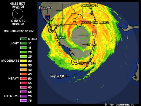
Monday, 9:00 am: on Friday afternoon the organizers of the Fort Lauderdale show postponed the opening from Thursday to Saturday, but I’m beginning to wonder if it will happen at all. As you can kind of make out in the radar shot above, Lauderdale is right now experiencing the worst portion of the storm’s eye wall. SSE gusts in Miami have hit 95 knots, and haven’t started to taper off yet. Wilma is moving fast, so South Florida will soon be able to assess how badly it got hammered. But even in good conditions the amount of boat handling, tent building, etc. that goes in this show is amazing. Of course the show is trivial compared to other problems Wilma is causing.
Argh! I haven’t gotten too exercised about Senator Rick Santorum’s bill to limit NOAA’s distribution of weather forecasts because I thought it simply too ridiculous to pass, but yesterday I came across this steaming pile of pure double speak. “Free the Weather” is a disinformation campaign run by CWSA—a trade association for the commercial weather industry—meant to support Santorum’s bill. The big lie is that NOAA’s National Weather Service is currently not required to dispense weather to the public, and has sometimes been tardy. That’s like arguing that your local fire department is not legally obliged to fight fires. So what?…that’s what they do. In fact NOAA does an amazing job of distributing data and forecasts both to the public and all the commercial interests that want to add value to it. And never mind that Santorum’s bill restricts distribution to "a set of data portals designed for volume access by commercial providers." Check out FreeTheWeather.org and see if it makes any sense to you. (For instance, they post an interesting series from the Miami Herald about frustrations at the Hurricane Center, but does they support the Santorum bill at all?) You might get mad, and you might want to contact your Senators and ask them to free S. 786 from its misery.
PS One of the neat things NOAA does, I think, is to give the public access to the hurricane forecaster’s discussion notes. It’s geeky stuff, but today you can learn that some of the computer models of wicked Wilma have her coming closer to New England than the current 5 prediction track shows. Damn!
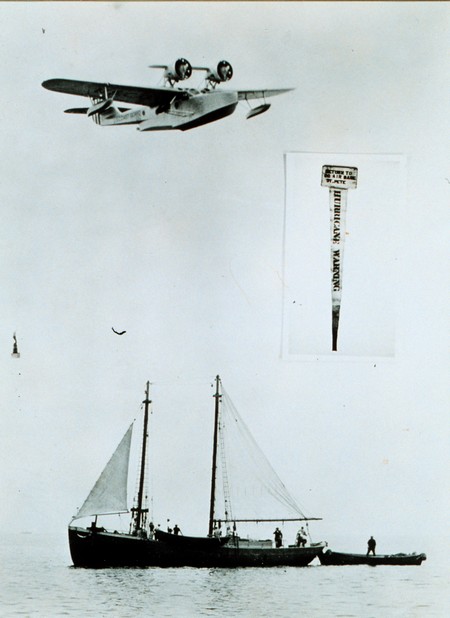
Hurricane Katrina whacked south Florida fairly hard yesterday and now it looks likely that she’ll power up and smack the northwest section of the state early next week. Per usual, there’s an extraordinary amount of data and valuable prediction information at the National Hurricane Center’s web site. Hurricanes are truly meteorological loose cannon, but it is amazing how far our ability to forecast them has advanced. I got to tour the NHC facility in Miami in early 2004 and was bowled over by the high levels of technology, data i/o, and brain power. That was the year that NHC’s back testing program indicated that their forecasting was good enough to begin issuing 5 day track predictions, which have no doubt saved lives and property since. By contrast, observe above how hurricane warnings were delivered to sponge boats off St. Pete, Florida, in 1938 (from NOAA’s online photo library).
Now, no idiot U.S. Senator (carrying water for a few private weather companies) is going to stop NOAA from distributing hurricane information, but, as you likely know, Senator Santorum of Pennsylvania does have a bill in process that might severely limit its ability to share less critical information. BoatU.S. has just posted a good editorial on the issue. Following one of its links, I found and used an easy e-mail form to register opposition to the bill with my senators. Why don’t you?
Update, 8/28: Naturally I’m curious if Katrina could reach Maine with any force, and I now see that the NHC has a new series of ‘experimental’ wind graphics that are quite valuable. This one shows me that the models now predict a 5–10% probability of over 50 knot winds on Thursday. Hmmmmm. Note that it can be animated if you click on ‘loop’.
If you have a fast Internet connection, you also have a zillion good weather resources at hand. I wouldn’t dare to say which are best. But one I’ve gravitated to over the years—even paid a tiny subscription fee to—is the Weather Underground. I think it started as a university science project, which may account for the name referencing a really desperate and counter productive 60’s political movement. Whatever, it’s great. The screen shot at right (bigger here) shows how you can zoom in on a NEXRAD radar animation which you can also customize to your taste. Wunderground now even identifies storm cells, which I’d only seen before on the high end satellite products from XM and The Weather Channel Marine. But it was interesting yesterday when that cell shown over Penobscot Bay sprung up right over my house. 12 minutes earlier it didn’t show on NEXRAD at all. In other words even the fanciest tools couldn’t have kept you out of the way. The front did clear the air though, making for a great first day of the Maine Boats & Harbors show in Rockland, which is where I’m headed. Have a wonderful weekend!


 If you have a fast Internet connection, you also have a zillion good weather resources at hand. I wouldn’t dare to say which are best. But one I’ve gravitated to over the years—even paid a tiny subscription fee to—is the Weather