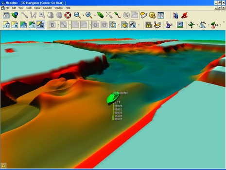
The above screen shot, full size here, is actually Nobeltec’s Bathy Recorder, a “plus pack” option to Admiral and VNS 8 that Jeppesen Marine introduced last year. I’ve seen these results of a tester’s survey of heavily dredged Port Everglades, and all the ways you can display it, demonstrated at a boat show, and it was quite impressive, though not inexpensive. But I’d neglected to mention this for so long that we are now seeing the arrival of Nobeltec 9! The press release went out last night, marking the start of the Newport Boat Show today (Admiral PDF here and VNS PDF here). Some highlights:
* Both Admiral and VNS will now display regular GRIB weather files and have new “Nav Info Panels” which can show strip charts as well as numbers. (All seen below and bigger here). * Admiral also gets “AIS Filtering” (I don’t know what that means yet) and now include OCENS WeatherNet. * Admiral 9 can also support a new Plus Pack called Tender Tracker which integrates with Seetrac hardware. * Either charting package can work with the new Sailing Plus Pack, which can display existing polars, build new ones, overlay laylines and wind info, and provide “basic instrument support for B&G and Ockam instruments”. * And either can support the new XM Plus Pack, which apparently integrates the WxWorx PC version of XM Marine Weather with Nobeltec.
So…wow…goodies for megayachts, racing sailors, and all the rest of us who care about weather (more detail and screen shots coming to Panbo soon). And we already know that Jeppesen/Nobeltec has been working with Simrad, and is also in a quiet period while it finalizes a deal to acquire C-Map. Looks like a really big year for these guys.
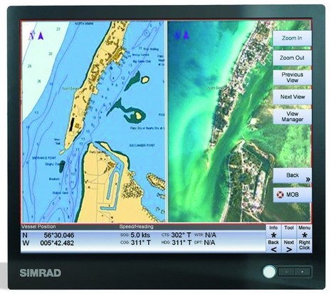
I was somewhat chagrined to open the latest issue of PMY and find a full page ad for an interesting new electronics system I had never heard of! I guess it’s hard to manage a world-wide product introduction; heck, even searching the Simrad Yachting site for the GB60, as this system is called, yields nada, at least today. At any rate, it’s pretty clear from the pictures and European press releases I found that Simrad Yachting has teamed up with Jeppesen Marine, i.e. Nobeltec. The PR references Passport charts, photo maps, etc. but the screen above sure looks like Admiral to me. Which is not a bad thing. Why reinvent the wheel, especially when you have all the hardware that a big Admiral glass bridge system wants to live in. When I visited Simrad a few years ago, I was surprised at how many commercial grade marine computer products they made. Hence there’s a lot of experience behind that dual processor black box PC below. Ditto the keyboard and even the cool arm rest control. Simrad has also been making, or at least OEMing, monitors for a while but these, available in 12”, 15” and 19” sizes, are a new super slim design. I dare say that a full 3 monitor GB60 system, like below (and really big here), will be pricey but powerful, and some will love that it’s all under one warranty. Intriguing detail: the system can talk NMEA 2000 (aka SimNet); will regular Nobeltec charting programs acquire 2000 soon? That would be a good thing.
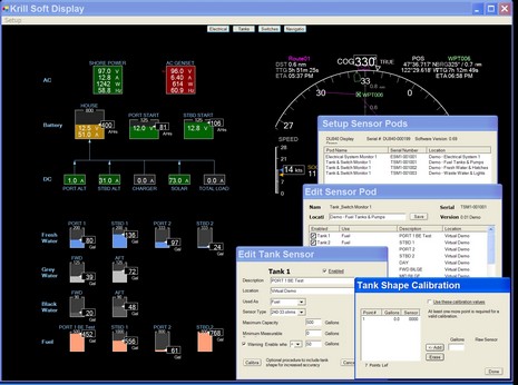
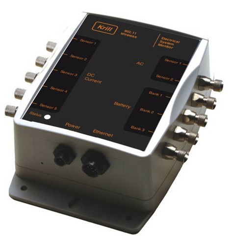
Did you cruise some mega systems with Intelisea on Monday? Well, now you might want to visit another relatively new monitoring company, Krill Systems, and download its SoftDisplay demo (it’s a single zipped .exe file and needs only XP or 2000 to run, no installation). You may miss that “carefor more champagne, sir?” feeling, but I think you’ll find well thought out software for monitoring important stuff on, say, a 45’ trawler. Krill is aiming for less than mega with a starter kit at $4,500. That gets you an Electrical System Sensor Pod (below), a Tank & Switch Sensor Pod, all cables and sensors, an Ethernet Switch, and the SoftDisplay to run on your yacht’s computer. Krill also makes a waterproof 8.4” display (a dedicated CE PC actually) with built-in WiFi lest the Ethernet run is too difficult. Of course more sensor pods can be added and, because Krill’s front end is a small PC application, off ship monitoring should be fairly easy to setup. Here’s the full image of the SoftDisplay screen above but you really should try the demo, drilling down to see how tanks are calibrated, bilge alarms set, etc. Also note developer Casey Cox’s unique bonus display of incoming NMEA navigation data.
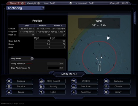
Stuck in an office far from your boat? Or maybe your mega ride is in the yard for repairs? Well, then, scooch on over to Intelisea, a relative new comer to the world of high end monitoring and control, and enjoy some mouse time touring its online demo. The software design is elegant (and admired in the programming community), and it’s fun to think of yourself minding a 100+’ yacht packed with sensors and PCs. Intelisea systems are being installed on three large new yachts right now, but the builder is so far unwilling to publicize them (frustrating for the sales guys!). The systems are “complete sensor-to-user solutions” and, of course, very customizable, but Intelisea does quote a “standard” price of 60k for a 30m yacht.
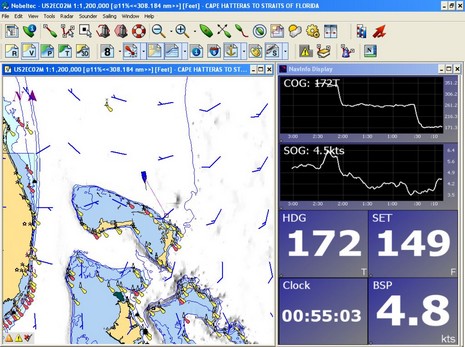
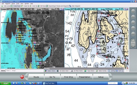
Actually I’ve been watching RayTech 6.0 for quite a while, as I was kindly included in the Beta testing. I think Raymarine really got it right this time. Take a look at the full screen shot, and consider all the cartography it supports. On the left is Navionics Platinum being read off a CF card in a Navionics USB reader; RayTech seems to speedily support every Platinum feature—including blended photo maps (shown), panoramic photos, 3D, port info, tides & currents, etc. (by contrast Navionics own NavPlanner hardly supports any Platinum features, yet). On the right of course is a Maptech raster chart; other Maptech products supported are photo maps (with variable blending) and topos. Finally, you can also read NT+ charts using a C-Map reader.
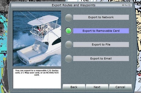
And consider how many ways there are to use RayTech 6.0. You can download it for free (yes, available now), grab some free rasters, and you’re all set to plan routes that you can copy onto a CF card and take to your Raymarine C or E, or email to someone, or whatever (see below, bigger here). Or you can buy a Navionics or C-Map reader and use your plotter charts to plan on, or at least compare to the rasters, again taking the routes to the plotter via card. Or you can license your copy of 6.0, and then a single Ethernet cable feeds it everything that’s on an E Series network (Sirius weather, Navtex, and AIS excepted, for the time being). I’m trying both networked and stand alone versions, as well as the Sirius weather, am impressed by all, and will report further.
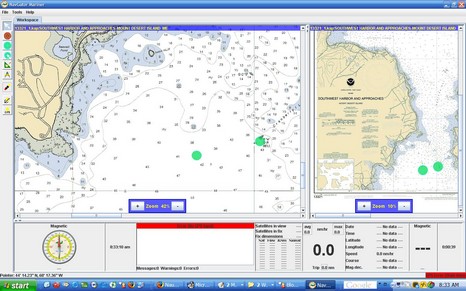
I’ll characterize NavGator Mariner, above, as a work in process. I couldn’t find many normal ECS features, only rasters are supported, and the chart management is crude to say the least. What’s interesting, though, is that NavGator is written in Java so that it can run on multiple operating systems. So far that means Windows, Linux, and Sun Solaris, but others will “soon be released”. The developer also has a Pro version “designed to be the core of the ‘glass cockpit’, where all electronic functions are integrated into a seamless, highly reliable, high performance environment.” The full screen shot is here (also showing off the full 1440 x 900 pixel goodness of my new laptop LCD).
Yesterday we learned for sure that Maptech has acquired a bunch more marine navigation products, which must somehow be integrated with all the products it already sells. Heck, the long list at right doesn’t even include its latest offering. Here’s a peek at how it’s going to work as explained to me by Maptech PR manager Martin Fox and others:
* The Capn charting software—apparently the main impetus for this deal—will become Maptech’s commercial level product, with customization and fleet pricing available. Recreational users may be offered an easy switch to Chart Navigator Pro, and certainly won’t be left adrift. Dennis Mills, always the chief developer of The Capn, stays on as Product Manager (and is tickled about it).
* The SoftChart brand, on the other hand, will not survive, but some of its technology will. The plan is not finalized but Maptech may adopt some SoftChart features like its highly saturated raster chart color pallet (very effective on dim monitors) as well as a much less obvious “vertices” technique that improves chart quilting. Supposedly there’s also some interesting vector chart assets changing hands. Like Mills, Dick Davis—director of SoftChart cartography since 1995, and head of NOAA’s raster development team before that—is pleased about where his work has ended up, though he will not be working for Maptech.
* Maptech is “not sure” yet what it’s going to do with MarinePlanner.com, but I recall that the site has some interesting weather forecasting, trip planning, and other goodies (though they�re almost all locked behind a �membership� scheme right now).
* Finally, Captain Jack’s online and print catalogs will come back to life, but as an operation “totally separate” from Maptech. Fox must have used that “separate” word a dozen times, which got me laughing and is an indication that Maptech is a little nervous about annoying its own dealers. At any rate, the new Captain Jack’s “won’t look anything like a Maptech catalog” and its emphasis will be on “solutions”, i.e. bundles of products like, say, a GPS loaded with waypoints from an included ChartKit Book. I dare say it will also still include a nice collection of PC charting accessories, and that’s good.
Panbo correspondant Jeff Siegel is excited about the nautical possibilities of this new PC architecture called UMPC, hyped recently as Origami, and I can see why. I got excited when the first tablet PCs came out, until I realized that you had to use a special stylus, awkward at a helm. A UMPC is a 7” tablet PC on whose touch screen a finger works just fine. Add a USB or Bluetooth GPS, or a whole electronics network connected via WiFi, plus a bracket, and this puppy might make a very nice navigator. (I suspect it might be particularly competitive against the dedicated car navigators). Of course it can do a whole lot more, and it’s supposed to price below $1,000, but some folks are skeptical.
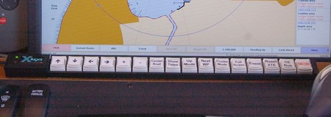
As noted yesterday, the owner/designer of the dual PC helm setup has found a nifty HID (Human Interface Device) that I’d never seen before (bigger here, and set up for Coastal Explorer). The X-keys Stick USB includes software (Mac version too) that lets you define macros and print out key labels, even white on black ones to best utilize the Stick’s backlighting. It is not waterproof, of course, but it sure looks like it would be useful in a pilot house when the going gets jiggy, or you just have other things to do with your hands. The 16 key version shown cost $80, and the company has all sorts of other programmable key boards.
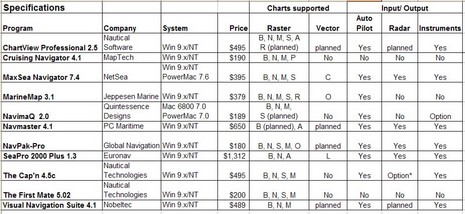
I was so wet behind the ears! One my first attempts at magazine writing was an overview of Electronic Charting Systems (ECS) for the Sept/Oct 1999 issue of Ocean Navigator. I spent months doing the research, actually installing and testing all eleven programs above (table bigger here), and wrote some 11,000 words on the subject. I recall that ON was surprised at the size of it, but published almost the whole thing (some is still online, titled "Power navigation", though you’ll need a subscription to read it).
At any rate—though I’ve tried to avoid big overview articles, particularly about ECS, ever since—I’m about to write one for Sail (which I’ll probably modify at some point for PMY). I’ve got to fit it in 2,000 words/six pages, and my idea is to highlight a good selection of particularly well done features, hopefully in as many different programs as possible. It goes with the idea that there is no perfect program for everyone, and that you can learn a lot about what’s possible via diligent shopping. I’d love your help. What do you think Nobeltec VNS, or Coastal Navigator, or RayTech or whatever does particularly well? And what ECS features are important to you, anyway? Please post ideas in the comments or just e-mail me. Developer comments welcome too.


 Yesterday