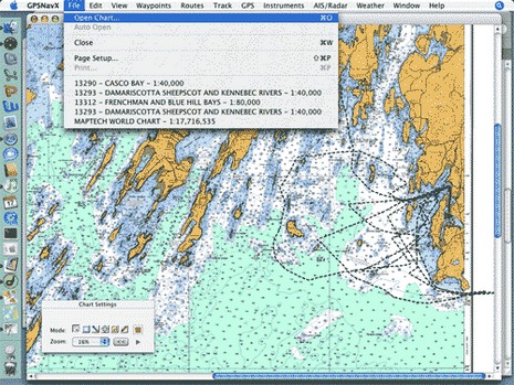
* Panbo reader Dan Hinckley has put together a thorough and useful review of his experience running both GPSNavX and MacENC on a Mac mini, which is where the screen shot above came from.
* A couple of readers have pointed out www.chartsdvd.com, which is the work of a sailing couple living in San Francisco. They’re offering all of NOAA’s free raster and vector charts on one DVD for $30, shipping included, nice and simple.
* At the other extreme of computer charting is WECDIS, the Warfare version of Electronic Chart Display and Information Systems. Slowly but surely the world’s navies are dumping paper charts in favor of WECDIS, or similar systems with different acronyms. The company supplying the British Royal Navy and hoping to get the U.S. business is OSI.
Touch screen does seem like “the natural interface” (as I just read at some promotional site), but there are two gripes about using it on the water: one, the technology can reduce precious screen brightness 10–20%, and, two, it’s hard to use when a boat starts bouncing around. Northstar has addressed both issues:
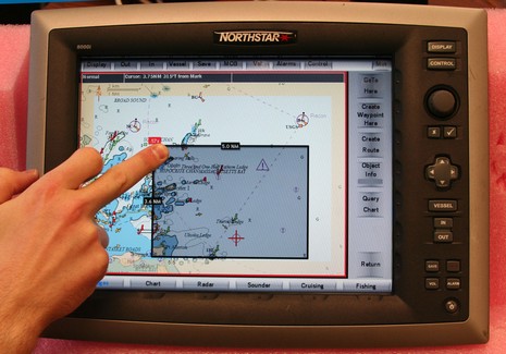
* The 8000i uses an unusual infrared touch screen technology; LEDs and photo cells hidden in the bezel create a invisible light grid which your fingertip interrupts. It seemed to work quite nicely during my demo and it doesn’t reduce screen brightness at all. Supposedly even gloved fingers and sticky fish scales won’t phase it. By the way, in the picture above (bigger here), the 8000i is zooming out by tapping a desired new center spot (red target) and dragging a box from lower right to upper left to define the zoom level. Left to right zooms in, the shaded borders let you pan, and all those touch keys can be hidden with the upper right ‘min’ button.
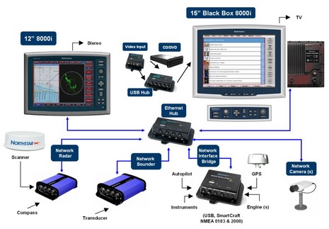
* But there are also zoom ‘in’ and ‘out’ buttons built right into the 12” 8000i, or you can plug in the dedicated key board seen in the system diagram with the 15” model, or you can use any other USB keyboard or pointing device. Interface flexibility!
This 12” unit, incidently, contains a 1.2 GHz processor and a 35 gig hard drive in addition to what seemed like a very bright screen, and it’s completely sealed. Yet, after a couple of hours of use, its relatively shallow aluminum back casing was barely warm, which I thought impressive, and a sign of durability.
The 8000i has a lot of sizzle, and some interesting new charts, but let’s start coverage with a system overview (bigger here):
* The sunlight viewable multifunction displays are Windows PCs; the 12” is self contained while the 15” is broken into monitor, processor, and keyboard modules. (Both units are also touch screen, but more on that later).
* This is a ‘masterless’ network, meaning that sounder, radar, cameras, and even the various sensor networks go directly to an Ethernet hub. If one PC is shut down, or craps out, it should not affect what the others can do. Several manufacturers have network black box sounders, and a couple have Ethernet radars, but this is the first time I’ve seen network cameras or a Network Interface Bridge (USB, SmartCraft, and NMEA 0183, with—hooray!—NMEA 2000 coming in the fall).
* The only exception to this ‘masterless’ design is that only one processor can be an entertainment server, burning CDs and DVDs with the built in ‘jukebox’ software. But then any display can play from the music and movie library at will, audio going to a nearby stereo and video either playing right on the 8000i screen or on a TV.
* All the parts shown, and the necessary cabling, are supposedly waterproof and marine tough.
Yes, it’s expensive—the 12” retails at $7,000–-but the 8000i looks like a smartly designed system, with a lot of redundancy, power, flexibility, and pizazz built in. More details to come.
I’m a sucker for anything that connects to a PC. The new AutoAnchor Rodecounter for the PC is an interface box that provides anchoring information for PC based applications. It is designed primarily for large yachts, with glass screen PC displays, but is also generating interest for use on smaller vessels using laptops. It features accurate rope/chain or all-chain rode counting, with pre-set calibrations for specific windlasses, a docking alarm to warn the skipper the anchor is approaching the boat, and “plug and play’ software. The company also produces units with a display. — Jeff Hummel
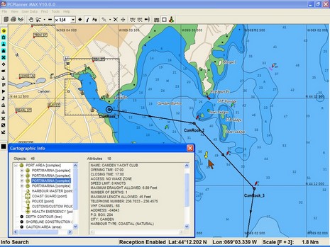
A C-Map question this morning reminded me that I’d meant to comment on my experience with the company’s latest PC Planner product. I’ve always liked the concept: bring home your chart card, stick it in Planner’s reader and use it to do fast, detailed route making on a PC, then bring the routes back to your plotter on a user card. These days Planner is a pretty mature program and also nicely shows off the goodies in C-Map's newish Max chart cards. Check out the streets, detailed harbor info, multi-shaded contours (land too), and even a yellow real time current arrow in the screen shot above (bigger here). The program can also display Max’s perspective view, animated nav lights, and harbor photos. I may have razzed C-Map last spring for its Max marketing, but I like the charts and PC Planner.
And I’ve wondered why Navionics has not yet introduced a similar product. (I have been told it was “about to happen” several times, including quite recently.) Even Garmin users can’t plan on a preprogrammed data card, though they can get the same effect by buying BlueCharts on a CD and making their own card (note that the new G2 charts will not be available on CD, at least at introduction).
At any rate, the question asked this morning was the cost for Malaysian C-Map charts for use on a PC. One reason for the long introduction is that PC charting programs supporting C-Maps can generally read them either from the CD version or from a card via the reader (SOB has a good explanation of the hows and whys here). A "Wide" size CD unlock code for the Malaysian area, either Max or regular NT+, costs about $250 and includes maybe 100 charts (you can drill down to name, scale, etc. detail using C-Map’s online catalog). I’m still working on prices for the applicable cards, which come in two possible sizes for the area; they’re likely a little higher, but can also be used in a dedicated plotter. I was surprised that I couldn’t find these prices online; I think Bluewater usually has such info but their system is down. Any suggestions for other online sources of worldwide electronic charts?
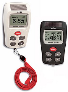
At METS, the U.K. company TackTick—a prior DAME winner for its Micronet wireless instruments—introduced these remote displays. Like the Micronet fixed displays, they’re solar powered and, using a Universal Wireless Interface, can show most any NMEA 0183 data, besides, of course, what’s collected with Micronet sensors. I’m just now realizing how powerful this Interface could be—capable of, say, data networking GPS, PC, another manufacturer’s instruments/sensors, and Micronet. In fact, TackTick even supports proprietary data sentences created on the boat’s PC and then displayed as desired on the Micronet screens (pdf here). It sounds like a savvy sailor or developer could use this to create a very sophisticated instrument system.
Speaking of which, Sailing Anarchy put up a fascinating piece on the super high end sail racing instrumentation that B&G is capable of these days. Note that it is apparently written by a B&G employee, but nonetheless…wow.
Here’s wishing all the Yanks in Panbo world a wonderful Thanksgiving holiday. It’s spitting snow here in Maine, perfect for holing up with friends, family, and a lots of good food. There’s much to give thanks for, but let’s include gizmos too. Needed they’re not, but aren’t they fun?
Whoa, things are happening even faster than enthusiastic yours truly thought possible. For $500, Maptech’s new Chart Navigator Pro (CNP) give’s you 13 (13!) DVDs containing NOAA’s entire portfolio of U.S. RNCs and ENCs, plus all of Maptech’s accessory cartography—photo maps, harbor panoramas, topos, bathy maps, pilot books, and information databases. But the real surprise inside is that Maptech ditched its aging, non-quilting, non-vector charting software in favor of Coastal Explorer. The name has changed, but CNP is CE 1.1 with nothing taken out and Maptech’s decent 3D contour engine added. CNP gets introduced today at the Fort Lauderdal Boat Show and will supposedly be in stores next month.
PS, 11/7: Thanks to Greg’s comment for a head’s up that Maptech has launched a new site, freeboatingcharts.com, where you can download all the U.S. RNCs you want. I don’t quite understand why Maptech is doing this before NOAA has a system in place, but it works fine. First you select the charts you want, then the site packages them up in a self executing zip file and notifies you when it’s ready for download. It only took maybe a half hour for me to receive the 15 charts that cover my area in all scales.
Last night Nobeltec announced the new features coming to VNS and Admiral 8.0 PC navigation software; they’ve been busy! Both packages integrate camera/video displays (for DirectX enabled cameras) and SkyMate communications, plus add a place-name search capability (all illustrated in my collage above, bigger here). Both also now support NOAA ENCs and will plot DSC VHF calls. AIS target tracking has expanded from Admiral to VNS and Nobeltec will be selling the single frequency NASA/Si-Tex AIS100 receiver [corrected 10/16]. Meanwhile, Admiral will now be able to support multiple radars and the InSight Sounder over a GlassBridge Network, resulting in such sexy system possibilities as the one diagrammed below.
One comment that inspired my “Geeks vs ME Empire” rant a while back was: “Megalomaniacal marine elex vendors disdain such commoditization as evidenced by the disappearance of most stand alone dumb GPS sensors and proprietary integration of d/s sounders into proprietary networks.” I really, really didn’t understand where that commenter was coming from. It strikes me that the planet is awash in GPS sensors that can output in NMEA 0183 format (or 2000) via bare wire, standard serial plug, USB, Bluetooth, etc. etc. I have a cheap Deluo mouse GPS that has swappable dongles so that it can output via DB9, USB, and custom iPaq PDA serial plugs (& get power too), and it’s worked with all sorts of software. How commoditized can you get?
And while it wasn’t long ago that all depth, speed, temp, etc. sensors were proprietary, these days Airmar (which makes most of them) offers a wide variety of “Smart” versions. More than I realized, actually, as I discovered at Airmar’s much improved web site (try the Smart Sensor .pdf for starters). As illustrated, these sensors process their own signals. Add power and out comes NMEA 0183 or 2000 data to feed a plotter or multifunction display from most any of the ME manufacturers or a PC or, in the 2000 case, a network of up to 50 separate devices. So what was that guy talking about?
How freakin coincidental! I was going to write a post today following up on “Geeks versus the evil M.E. empire”, but damned if some software didn’t hijack my computer, and my attention, for a significant chunk of the day. It was Adobe Acrobat, a big time program, and one that’s been running fine since I bought this top-of-the-line Dell and installed my fav software on it last December. All of a sudden Acrobat just wouldn’t open a .pdf file, hanging up on the opening splash screen. I tried everything. I installed updates; didn’t work. I went into the Add/Remove Programs dialog and asked Acrobat to “repair” itself; not. (Along the way, I rebooted the machine many times, and quite lost track of all the tasks on my desk today). I used Window XP System Restore (twice) in an attempt to go back a few days to when Acrobat did work; nada. I completely uninstalled and reinstalled Acrobat; still it hung up! That’s when I fled to the gym to watch CNN and sweat for a while.
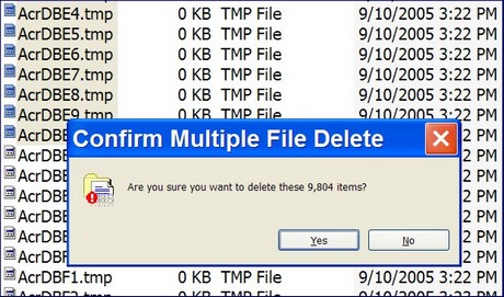
Finally I Goggled “adobe won't open” and—bingo—learned from some other users somewhere that a glitch in Acrobat can sometimes cause it to create, then choke on, thousands of .tmp files in an obscure directory. Sure enough, there they are above. Even this powerhouse couldn’t delete them all at once. I had to hack through them 6–10 thousand at a time. There must have been over 100,000 files created in just the last few days (and XP’s “clean up” disk utility doesn’t go near them). Finally I can open a .pdf file, though Acrobat is asking me register again (for the 4th or 5th time, I think). So even now I’m not quite back to where I was before this glitch, and I have no assurance that it won’t happen again.
Please don’t write that I should have Googled, or gone to Adobe help, first…you know that can be a wild goose chase. And please don’t tell me that I should be using a Mac or Linux or something…if you haven’t had problems with those it’s largely because can’t fool with a fraction of the software I use.
Most days I love computers, and I’ve had pretty good luck using them on boats. But today is a day I certainly understand people who despise them, and are happy to spend good money for a dedicated plotter instead of chancing navigation on one of these FUBAR machines.


 At METS, the U.K. company TackTick—a prior
 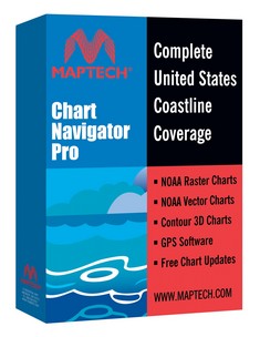 Whoa, things are happening even faster than enthusiastic yours truly
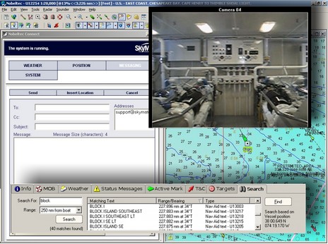

 n NMEA 0183 format (or 2000) via bare wire, standard serial plug, USB, Bluetooth, etc. etc. I have a cheap