The race to get hard drives into cell phones and PDAs may result in drives that really lend themselves to tough marine environments. Hitachi just announced a 1”, 8 gigabyte drive with ESP (“Extra Sensory Protection”). It uses a 3-axis accelerometer to detect a fall in as short as four inches and switch into non-operational mode, which according to Hitachi can handle 2000 Gs of shock. It’s hard to imagine where such tiny, rugged drives will take us… or to fathom what it means about the future when tech companies name a hard drive "Mikey" and promote it as “the new bling!” Is it politically incorrect to laugh, imagining a roomful of Asian marketing execs discussing “bling”?
Update 9/7: How timely; today Apple announced a new iPod “nano” that obviously uses a drive like "Mikey". Walt Mossberg, the gadget guy at The Wall Street Journal, is in love with it.
Last week, when I enthused about plotters displaying DVDs, reader Don Parker unloaded on me about how easy this is to do with an onboard PC. He further expressed his general disgust with the “megalomaniacal” marine electronics industry and took a shot at me for failing to point out “when the value added doesn't justify the price”. And Don is not the only smart, techy reader who has a bad attitude toward the electronics companies, and thinks I’m too positive about them. A recent e-mail from Mike took me to the woodshed over the enthusiasm I’ve expressed for NMEA 2000 here and in PMY, and ended with, “You need to think hard about whether you are a reviewer, columnist, or cheerleader for the industry.” Ouch!
Don and Mike are both computer industry veterans and both have some points worth discussing, but first some generalities. Fellas, I have no dog in this fight! In fact I don’t even see a fight. There are perfectly good reasons that some boaters like dedicated electronics, others like computer centric solutions. I use both, and am enthusiastic that both are advancing (and, hey, I write for what are called “enthusiast” publications). The marine electronics industry is not a big nasty monolith out to do you you harm. It’s comprised of tiny to medium size companies, and a lot of generally decent people, competing to make products that make money. If one thought it could do that peddling a generic radar sensor, for instance, there’s nothing to stop them from trying. (I wish this would happen too, Don, but don’t see anyone to blame). And what is value? Getting a powerful system cheap, even if you have to do a lot of friggin around to make it all work? Getting a proprietary system that works pretty well and is all supported by one company, though expensive? There are many angles on this subject. Don, for instance, is using an expensive SeaView computer monitor (right) that came out a few years ago with much hoopla (so waterproof that it was exhibited in a fish tank). The brand didn’t last much longer than a year, and I’m not sure Don can even get his repaired at this point. Was that good value? Unfortunately this sort of thing has happened fairly often with marine computer gear, which has turned some boaters off on that choice. (I’m seeing boaters who used to navigate with laptops switching to plotters, because they’ve gotten so much better, and in a situation like Don’s—a 42’ sailboat—they can be mounted and used right at the helm). At any rate, I don’t get the anger, but will deal with more of Mike and Don’s feedback soon.
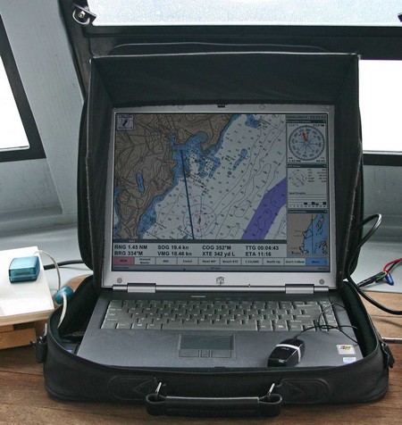
Over at rec.boats.electronics there’s a great thread underway about the ‘perfect’ built-in onboard computer. I’m particularly interested as I’ll likely go that route if and when I ever manage to finagle a larger cruising boat. In the meantime, last week I put some miles on the rather funky rig above (bigger here), and it actually performed pretty darn well, even gunkholing around the hairy unmarked ledges in Penobscot Bay’s outer waters (it was calm and clear). I used the old soft case (and sometimes a towel) to keep the laptop from sliding around. Valuable accessories are the Hoodman screen hood (really cuts glare, though I notice they don't seem to sell this model anymore), a tiny Atek optical USB mouse, and an old Deluo USB GPS (no WAAS and weak signals in my cabin, but still consistently accurate). Here I’m using Coastal Explorer 1.1 (now shipping), which is giving me that “the more I use it, the more I like it” feeling. It happens that the designer of CE has an interesting description of his own onboard PC system here.
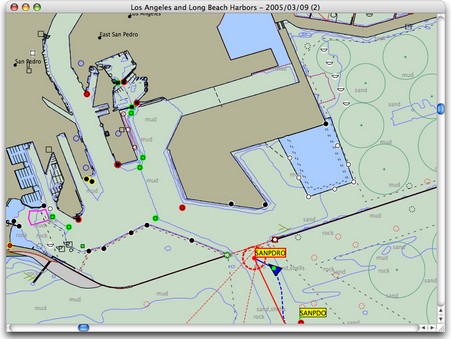
It was just last week that Rich Ray sent me this screenshot of MacENC, a new version of his GPSNavX charting program that supports NOAA’s free ENC vector charts. But after Tuesday’s news about free raster charts, it no longer seems like a big deal. Now we know that by about next spring Rich and other developers will probably be able to sell their charting software on a DVD that includes the digital equivalent of every single NOAA U.S. paper chart, without any encryption hassels and at little added cost. And users will be able to update those charts weekly if they want (making that easy will be another chance for developers to add value). But ENCs aren’t going away. They’re better than RNCs in many ways, and they’re definitely the future. Eventually—when ENCs are perfected and coverage complete—NOAA will drop raster chart production altogether, even printing paper charts from the vector database (if they print charts at all). Right now it’s quite useful to have both RNCs and ENCs for the same area; each has data or display features that the other lacks. In fact, if I was a Mac person, I wouldn’t think twice about paying the extra $35 for MacENC. I’m looking forward to inexpensive DVDs loaded with both types of free U.S. charts.
By the way, breaking the raster story generated a record number of readers here at Panbo, and for a moment made me feel like Matt Drudge (in a good way). A big thanks to whoever it was out there e-mailing Panbo links all over the planet!
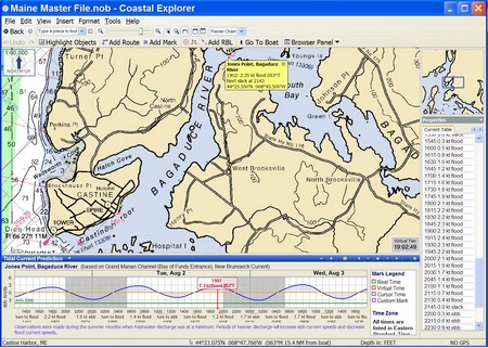
Rosepoint Navigation’s Coastal Explorer is now in “open Beta”, meaning it’s essentially done and available for download by all registered 1.0 users. The retail version should be coming along soon. The “1.1” tag is dry humor; there are so many major additions to the program that they could justify a jump to 5.0 or beyond if they felt like it. At any rate, above (bigger here) is an example of the new tides and current prediction functions. They are extremely well done; you can easily animate multiple onscreen tide and current stations and/or get graphic, tabular, or text info for any one station. Bravo!
I chose the particular area above so I could tell you something about coastal Maine, and the characters who live here. That light blue area (you really need to look at the full screen) is the Bagaduce River, which isn’t a river at all, but rather a long, complicated tidal bay (that extends well beyond the chart window). 10 feet of tide is trying to fill or drain that whole area every 6+ hours, hence the 2.3 kn current at the Jones Point station I’ve selected. The coast is so complex, and the prediction stations so spread out, that Maine boaters become amateur hydrographers, able to guesstimate current strength by looking at the chart and a tide table.
Mainers can also be crusty. The story goes that there was quite a contentious town meeting when that little bridge (lower right) was built. One gentlemen got up and said, “Why the hell should it cost so much; I could piss half away across there.” To which the moderator replied, “Sir, you’re out of order.” And got back: “You’re damn right I’m out of order; if I wasn’t I could piss all the way across!”
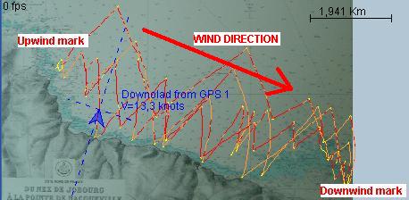
Above is output from a free program developed in France called GPSActionRelay. It is written in Java, and will suppossedly run on any operating system. Features include replay of several boats in a regatta, polar diagrams, VMG, speed averages, etc. It looks pretty complicated but apparently is used by some sailing teams and a number of geeky windsurfers. I’d like to know what hardware they carry on their boards at 46.7 knots (yi!), but couldn’t find any information. A Garmin wearable Forerunner perhaps? And if so couldn’t heart rate be graphed to speed?
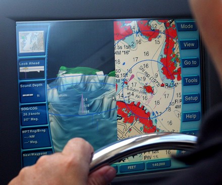
A bonus of my trip to Annapolis was getting to try Maptech’s third generation i3. I first saw this system back in 2001, when it was being developed as the Sea Ray Navigator (and it’s still going on many new Sea Rays under that name, despite parent Brunswick’s own move into electronics). Last summer I enjoyed a live demo of the second generation system, which Maptech had begun to market on its own as i3. By then the developers had added radar plus optional touch screen versions of Weather Channel Marine and SkyMate. Now Maptech owns the contractor that actually builds the i3 hardware, and the new Type 3 is a significant upgrade. The screen is more stylish, more colorful, and brighter, and the software flys. Plus there are many interface improvements (besides the 3D fishfinder option). In the screen above (bigger here), notice how the radar range rings can be shown on the 3D screen to make better sense of relative scales. Notice too how the 3D is automatically exaggerated to make the good, and bad, sections of this relatively shallow river (hey, I live in Maine) obvious. Look at how well the radar is synched to the chart, despite the fact that there is no electronic compass in this particular install and we’re doing 26 knots (which is why the depth sounder isn’t reading; the transducer needed better fairing for high speed). It’s not shown but Type 3 also lets you remove the side menus, or make critical info semi transparent, so you get more chart on the 12” screen. And, finally, there’s now a 15” screen version too. i3/SRN is not just a unique concept; it’s an evolving family of functions.
Monitoring and control systems can potentially do anything. Once you have a system of sensors, cable backbones, PCs, screens, and so forth performing the core task of collecting and distributing information and system commands, well heck, why not blend in security, entertainment, communications, inventory/maintenance management, digital documentation…whatever. A case in point is Hyperion (above), the 157’ super yacht built in 1998 by Royal Huisman for the legendary Silicon Valley entrepreneur Jim Clark. Clark had to start a small company called Seascape Communications to create the system he envisioned, and what a humdinger the resulting “Genisys” is. 24 onboard computers monitor 50,000 data points and display on 22 touch screens throughout the vessel. Clark and his crew could mind and manage everything from windshield wipers to ballast transfer pumps to e-mail wherever they wished onboard. Clark could even “cruise” the yacht by satellite from his den in California (or his airplane), leading to the waggish comment that it was the world’s largest remote control toy. And guests had their own screens mounted into berth-side drawers so that they can amuse themselves with the system’s 1200 CD’s on hard disk, 400 DVD’s in changers, world band tuners, and masthead cameras!
Since then, Clark had Royal Huisman build him the even larger yacht Athena, launched last fall, with more Seascape software on board. Now he’s announced the formation of CommandScape, which sounds like Seascape repurposed to automate large homes as well as yachts. Clark was the subject of the wonderful biography The New, New Thing, which begins with a hysterical description of Hyperion’s trail run in rough weather—failing computers, seasick film crew, et all…a must read excerpt here).
Big power outage here earlier this morning…coffee bean grinder no grind, DSL modem no blink…I’m definitely off my stride. I’m declaring this an OFI Friday, and will soon be off to fool with the fleet. If you’re stuck inside somewhere, you might want to picture yourself strolling down a dock with this Flintstone tablet PC in hand (for full effect, include the GSM whip antenna not screwed onto this prototype). I saw it displayed at a show once, and the developer’s site is still up, but I’ve never seen one in the field. In my fantasy, the case is carbon black and the boat I’m strolling toward is the Wally 118. Oh yeah.
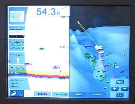
I’m on the road to Annapolis where I’ll get to trial Maptech’s wild new fishfinder module for its i3 system, maybe catch a croaker too. The poor photo above is of a simulation playing at the Miami Boat Show introduction. You can see on the left a regular 2D fishfinder screen while on the right the fish targets have been placed into a 3D bathy model; among other things, you can control how long targets stay on screen so that you can learn where fish hang out over time. Then on Thursday I’m visiting Airmar, source of the transducer and processor behind this module, and much more. My posting may get a little raggedy.


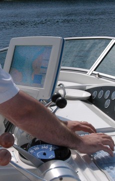 The marine electronics industry is not a big nasty monolith out to do you you harm. It’s comprised of tiny to medium size companies, and a lot of generally decent people, competing to make products that make money. If one thought it could do that peddling a generic radar sensor, for instance, there’s nothing to stop them from trying. (I wish this would happen too, Don, but don’t see anyone to blame). And what is value? Getting a powerful system cheap, even if you have to do a lot of friggin around to make it all work? Getting a proprietary system that works pretty well and is all supported by one company, though expensive? There are many angles on this subject. Don, for instance, is using an expensive SeaView computer monitor (right) that came out a few years ago with much hoopla (so waterproof that it was exhibited in a fish tank). The brand didn’t last much longer than a year, and I’m not sure Don can even get his repaired at this point. Was that good value? Unfortunately this sort of thing has happened fairly often with marine computer gear, which has turned some boaters off on that choice. (I’m seeing boaters who used to navigate with laptops switching to plotters, because they’ve gotten so much better, and in a situation like Don’s—a 42’ sailboat—they can be mounted and used right at the helm). At any rate, I don’t get the anger, but will deal with more of Mike and Don’s feedback soon.