
ECS roundup, your suggestions please!
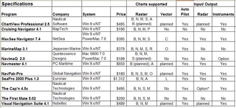
I was so wet behind the ears! One my first attempts at magazine writing was an overview of Electronic Charting Systems (ECS) for the Sept/Oct 1999 issue of Ocean Navigator. I spent months doing the research, actually installing and testing all eleven programs above (table bigger here), and wrote some 11,000 words on the subject. I recall that ON was surprised at the size of it, but published almost the whole thing (some is still online, titled "Power navigation", though you’ll need a subscription to read it).
At any rate—though I’ve tried to avoid big overview articles, particularly about ECS, ever since—I’m about to write one for Sail (which I’ll probably modify at some point for PMY). I’ve got to fit it in 2,000 words/six pages, and my idea is to highlight a good selection of particularly well done features, hopefully in as many different programs as possible. It goes with the idea that there is no perfect program for everyone, and that you can learn a lot about what’s possible via diligent shopping. I’d love your help. What do you think Nobeltec VNS, or Coastal Navigator, or RayTech or whatever does particularly well? And what ECS features are important to you, anyway? Please post ideas in the comments or just e-mail me. Developer comments welcome too.
I've used Maxsea, then converted to Coastal Explorer. Briefly, what I like about CE:
1. The user interface "feels right" to anyone used to Windows.
2. Seamless quilting of vector and raster charts.
3. Included AIS functionality.
4. Included, seamless (cliche, yes, but what the heck), access to US-only photo images from Terraserver. Overlayable on charts.
5. Easy downloading and import of US Noaa ENC charts.
6. Terrific chart portfolio management function. Determine what charts are were on your PC, whether they should be displayed, etc.
7. Very robust! Almost never hangs or malfunctions.
Dave