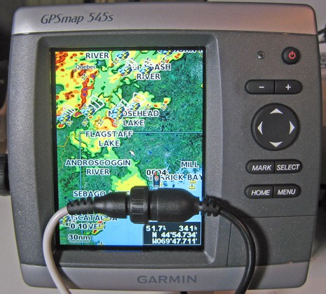
I’ve got the new Garmin GXM 31 hooked up to the 545s, and am once again impressed with how deep this “product line refresh” really went. I’ve tested Garmin XM weather on several devices over the years, and saw the interface get better and better. But they threw a lot of it away in favor of an easier, if less tweakable, presentation. For instance, the only control you have over the main chart overlay above is weather on/off, Nexrad animation on/off, and legend on/off. But the data selection is good (yes it rained shortly after that photo), and for more weather you go to the main Information menu where you’ll find a selection of weather presets, each modestly tweakable from the menu key. I didn’t have the manual at first, but pretty much figured out all the possibilties on my own.
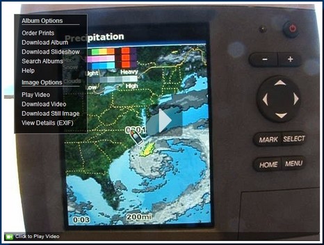
I’ve been feeling mighty guilty about my oh-so-slow testing of the borrowed Garmin 545. So it was particularly great to find that a fisherman named Tom has posted a useful series of stills and videos illustrating many 545 features. His Bluewaterpirates Phanfare album may be called “XM Music Functionality” but you’ll find dope on the new Vision charts plus a nice “new section” showing all the XM weather functions using a dramatic offshore low, and more. Enjoy.
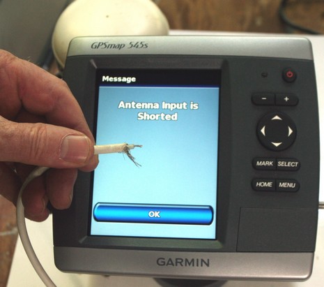
OK, it wasn’t the smartest move, me trying to jam the cable back into a very funky old external antenna while the Garmin 545s it was attached to was still running. Apparently I shorted the cable because, surprise, the Garmin beeped and told me so! I can’t say that I’ve tried this on any other GPS, but doubt I’d get such an informative reaction. One more check on the smart interface list.
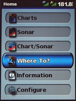
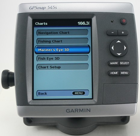
I’m getting to know the new Garmins slowly but surely, and one of the many things I like is the way choices you don’t actually have aren’t there to confuse you. For instance, if you start one without the transducer attached those “Sonar” and “Chart/Sonar” buttons on the Home menu above just aren’t there. Similarly, if you go into the Charts menu below without a g2 Vision card in the slot (nifty magnetic latch door, by the way), your choices will only be “Navigation Chart”, “Mariner’s Eye”, and “Chart Setup”. The interface is smart like that pretty much everywhere. In fact, I’d recommend learning this machine first without a card even if you get one with it (assuming you get a unit with built-in charts). But you may very well want to use a card eventually. Garmin has done well at making these MFDs quite good as is, but then piling so many more goodies (like those Fishing screens) into the cards that you’ll be truly tempted. But at least they don’t rub the features you don’t have in your face. Now, do you notice anything different about the photo below? I finally sprung for some decent lights and a soft box, and these are my first shots. A bigger crop of the image below is pretty darn close to what the screen and the interesting flecked casing actually look like. And the images should get better still as I learn the gear.
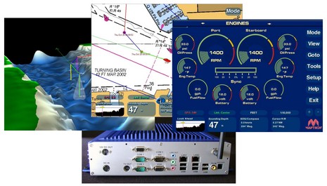
My June PMY column about Faria’s do-it-all PC-based Maestro helm system is now online, along with write-ups of the ACR ResQFix PLB, McMurdo SmartFind EPIRB, Icom M34 handheld VHF, and Cobra 425 handheld (I know, the picture is of the F80; we’ll fix it). Maestro is quite a system, and I’m glad that Faria now has dope about it on their Web site (online marketing is not the company’s forte, but they have strong relationships with lots of boatbuilders, which may be more important in the case of Maestro). Bigger here is the collage below which I made to illustrate some of Maestro’s connectivity. I believe the finished version also has a PCMCIA card slot on the back, meant for a cellular data card. Also online are all four of PMY’s June electronics features, including my take on ideal systems (which some of you contributed to back in March). The piece got titled “Perfect Picks” though of course they’re not, which I’ll probably be hearing about from manufacturers at any moment! Meanwhile some of you have asked about PMY’s sale to the “supermarket mogul” Ron Burkle. Well, rumor has it that we may be included in a secondary sale to some other publishing conglomerate, and, besides, we’re doing fine…in short, “business as usual”. In fact I’m writing my 73rd straight monthly column right now. Year seven at PMY begins.
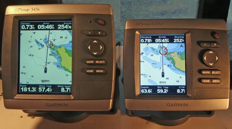
I really don’t know where to start with the new Garmins (here, here, and here); there’s so much of interest about the interface, performance, and the Vision charts. At least they’re pretty similar model to model, or at least the two I have in the lab. But I had heard—actually in the exercise room at my local YMCA (!)—that the 4” models were brighter than the 5”. My photo above, bigger here, tends to confirm that, though in real life, inside or outside, the difference doesn’t seem quite so emphatic. They’re both pretty bright. And note the resolution difference; the 545 is full VGA, 480 x 640 pixels, while the 430 is QVGA, 240 x 320 pixels. In the larger photo, the difference is particularly obvious on the numeric data; in use, the finer detail of the higher res screen seems evident everywhere. But note that Garmin also has a new series of 5” QVGA plotters, which I haven’t seen. The 520, 530, 540, and 550 all have QVGA, while the 525, 535, 545, and 555 are VGA. So, ah ha!, the model number’s first digit indicates screen size, the second tells you what charts come loaded—none, U.S. inland, U.S. coastal, or U.K. (or Australia) in ascending order—and the third subtly tells you what the screen resolution is. (For clarity, the chart on the 430 above is on a card, not in internal memory). Then when get up into the 4 digit networked series, the screen size moves to the last 2 digits, while the first is the style, and second is chart load. Hey, I’m just explaining, not criticizing; coming up with rational model numbers is hard work! By the way, Garmin’s 400500Series page now has a nice “compare” feature.
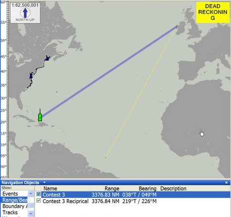
So let’s talk about issues with the last photo contest. My hope was that someone would figure out that the coral patches, steep drop off, and north facing channel had to be in the Turks and Caicos Islands, specifically the entrance to Turtle Cove, Provo. Then you could refine the boat’s location to 21d 47.806’N, 072d 12.453’W (I can’t get this software to insert the degree symbol so I’m using “d”). Then you’d use some navigation software or machine to create a relative waypoint at 039d True and 3,377 nautical miles (off the contest screen), which—ta-ta—would turn out to be Clare Island, Ireland. You can do this on a Raymarine E-Series but I’m not sure where else. That’s because the E is doing its calculations in great circle geometry, which means that the bearing is going to change as you travel along the course.
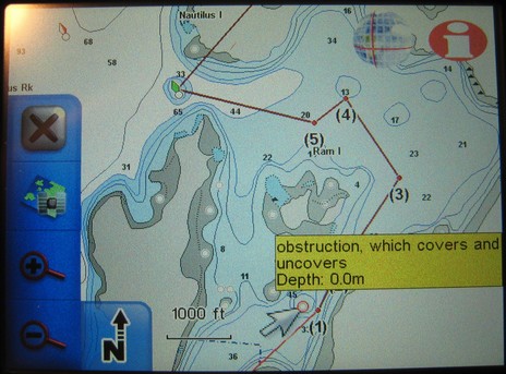
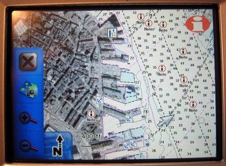
I’ve already written a bit about listening to tunes while navigating the highways on the iWay; how about boat nav? First is the good news that Lowrance has fixed the problem with “obstructions which cover”; you may recall that the “really nasty rock” above, and many like it, were not shown on earlier NauticPath charts. (In fact, the first iWay I got didn’t have them either, but when I piped up, Lowrance said the wrong files were accidently loaded, and sent this one. If you have NauticPaths, you might want to check). Note that the yellow note window popped up when I touched the symbol, and I could get a whole page of info by next touching the “i” icon upper right (ditto with the tides, notes, marinas etc. in the lower image). Note too that tapping the “X” upper left would take me out of this pan and zoom mode and back to my vessel (or car), leaving only a map orientation button lower left. Tap that and you cycle through top down/north up (as shown), top town/course up, and 3D. This applies to any type of navigation; in fact, most everything does. Unlike some Garmins—which switch screen sets and units of measurement along with nav mode—when you go from turn-by-turn car nav to point-to-point marine nav, the only other thing that changes is your choice of cartography. Changing to knots/nautical miles isn’t even a choice elsewhere. In other words, as well as the nautical charts are displayed, boat navigation is secondary to auto nav on the iWay (for more check the manuals here). But let’s not forget the 25 gigs of goodies include nautical charts for the whole country, plus a lot of lakes, plus zillions of POIs, street maps, and photo maps. The latter cover many cities, like Boston’s North End below. (I guess I picked that spot remembering my time there a year ago, getting a little ‘treatment’. Glad that’s over.)
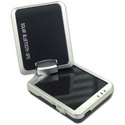
When Captn Jack’s lent me an i-Blue 757 GPS last month, they were clever enough to put it in “logging” mode before they sealed the box. Thus, once I sorted out the included software and downloaded the saved log points (30,591 of them!), I was able to see the box’s UPS trip from Massachusetts to my house overlaid on Google Earth. Now that’s a damn sensitive receiver that can hold onto GPS satellites inside a box inside a series of brown trucks! And obviously the i-Blue’s 1000mAh Lithium battery is pretty long lived even when it’s not being trickle charged by its 25mA solar panel. By the way, note the lat/longs shown in the i-Blue’s PC utility software below; in Google Earth I was able to drill down to a factory parking lot in northern Taiwan where the unit was probably tested for the first time. While I like logging for tasks like mapping island trails, and the i-Blue is certainly an easy way to bring home a visual cruising history, I found that it also serves quite well as a Bluetooth GPS sensor to Pocket PC and laptop charting programs. It even has a unique standby feature that worked fine, and is well explained in this thorough Pocket GPS World review. Note that you use a USB cable to charge the i-Blue and also to download logs and set GPS and logging parameters. I didn’t check if someone without Bluetooth could use the USB connection as a GPS feed, and the otherwise good manual doesn’t say, but I will get another chance as I liked this gizmo so much I’m buying one. I tried an EMTAC Trine Bluetooth GPS that Captn Jack also sells, and while I’d say it’s noticeably sturdier than the i-Blue, I’m going for the lower price and logging capability. I do like how Jack’s is selecting good, better, best products in several categories like this and WiFi, and recommend downloading the new catalog PDF, which seems to include some gear not yet on its Web site.
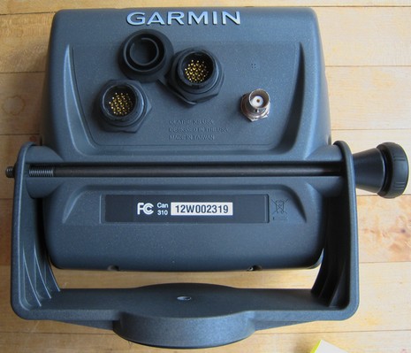
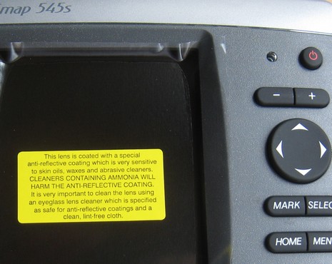
Geez, I’m so behind on testing (Cobra radios and Lowrance iWay are the ones half done, and there’s some I haven’t even started, sorry all!), I hesitate to get started on this Garmin 545s. On the other hand, the interest is great, myself included! Above is a backside shot showing the new two-way swivel bracket, and also the ports. Right is a BNC connector for an optional external antenna, middle is a connector for the still somewhat mysterious GXM 31 antenna, and left goes a cable that contains power leads, 2 sets of NMEA 0183 i/o leads, a set of CANet leads, and a power/data plug for the the dual frequency transducer. The unit is not quite as blue as the picture somehow came out, and the tooling is beautiful. The 545s manual is now online for more info, and I will try to show you what it can do as the week goes on (I’ve got a g2 Vision card too), though I probably won’t get it out on the water for a couple of weeks (and, by gorry, I’m going to finish those other units). Meanwhile I include the picture below as a reminder to everyone installing and reinstalling electronics this spring. Be very careful with your screens unless you’re positive that they’re not coated.


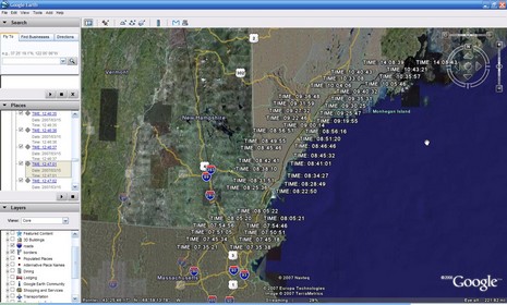
 Now that’s a damn sensitive receiver that can hold onto GPS satellites inside a box inside a series of brown trucks! And obviously the i-Blue’s 1000mAh Lithium battery is pretty long lived even when it’s not being trickle charged by its 25mA solar panel. By the way, note the lat/longs shown in the i-Blue’s PC utility software below; in Google Earth I was able to drill down to a factory parking lot in northern Taiwan where the unit was probably tested for the first time.