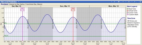
Today is not exactly like 12/31/1999, but there definitely are some questions about what’s going to automatically understand the Daylight Saving Change tomorrow, and what isn’t. For instance, will your Windows PC? Apparently that depends on update status, and ditto for Macs. Now, I already discussed the update planned for Nobeltec’s Tides & Currents, but it turns out that the 9.1.2213 service pack for VNS and Admiral 9 just finally released today, which seems a bit tardy! (I also understand that Nobeltec is not yet supporting Vista, but I’m not sure any other ECS is.) I got wondering about other tide prediction programs. It turns out that at least Coastal Explorer get its time from the computer it’s on. Why didn’t T&C take this easy approach? Well, if a program doesn’t know about DST, it can’t use it when predicting tides in the future. That’s why there’s no sign of the DST change tomorrow in CE’s tide table above, and bigger here, as calculated today. (I also notice that CE is figuring Rockland tides off of Bar Harbor, whereas T&C uses NOAA’s harmonics for Rockland, not wicked important but more accurate). As for all the chart plotters that can predict tides, I think they all base their time on GPS input plus or minus a local, user entered, offset. For instance, if you’re in Eastern Standard Time, five hours later than Universal Time (aka GMT), tomorrow you “spring ahead” to EDT by changing a Raymarine’s offset to -4.0.
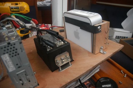
I think I had a pretty good idea yesterday, encouraging you all to submit your visions of ideal gear set-ups, but I made it much too complicated. Now you’ll see below that I’ve simplified the categories into classic “good, better, best” terms, and also started (crude) Web pages for system descriptions that come via email. These could become valuable resources not only for my writing projects, but for anyone trying to think through a nav/comms system of their own. Isn’t it interesting, for instance, that the first two submissions in the “better” category represent two quite different approaches and brand choices (both reasonable, I think)? Richard’s came with these photos of his Mac Mini install, and his “Thanks to GPSnavX for giving me the privilege to not have to run Windows for navigation!”, which makes the second time this week that he’s gotten raves here.
I’ve already described the premise below, and here are some vague notions of the three categories, plus links to some responses. Please share your ideal gear ideas via comments or email. Thanks.
Good: About a 30’ cruising sail or powerboat doing short hops along coast with the occasional overnight trips; budget/value is important. Submissions so far (3/19/07).
Better: Typically a 40’ +/- cruising powerboat capable of trips, say, up into Canada or out to the Bahamas, including occasional overnight runs; the budget is good but not over the top. Sailboats in this category would certainly include racer/cruisers used for extended coastal cruising combined with ocean racing events like the Marblehead-Halifax and Bermuda races. Submissions so far plus Dan’s sailboat (3/24/07).
Best: 50’ and better bluewater cruisers, sailboat ready for a circumnavigation including high latitude sailing, powerboat capable of ocean crossings and remote explorations; very healthy budget. Submissions so far (3/24/07), plus check out Panbo entries on Bluewater and Spirit of Zopilote.
Alrighty, then, time to quit my whining and really put Panbo to work. And I mean YOU! I have a Sail feature assignment to “design ideal navigation and communications gear set-ups” for three different size but fairly typical saltwater cruising boats, and I’m doing something similar in PMY). Obviously it’s a terrifying opportunity to piss off all the manufacturers who don’t make the lists. And it’s also impossible. There’s so much good gear out there, and so many personal variables to what’s “ideal”—simplicity vs. whiz bang, reliability vs. new new, embedded vs. computer-based, single brand vs. many, good value vs. gimme-the-best…etc. etc. But let’s give it shot; it’ll be educational. Whether you’re a pro installer, boat owner, or a dreamer, tell us what your ideal set-up would be for. The only categories we’ll go for will be “good, better, best”, sail or power, as detailed in the entry above. Please submit your ideas in the comments section, or by email for addition to the Web pages I’ll create for each category (and please tell me if I can use your name here and in magazines). Equipment chosen should be at least real enough that you can order it. Of course we’d like to hear about the thinking behind your decisions, and detailed gear lists, photos, helm mockups, and system diagrams are all very welcome. In return you’ll get the chance to share your ideas, a possible magazine credit, and my gratitude.
I kid you not when I say I've had my eye on this product for many months. Now some real info has come to Kelvin Hughes' SharpEye Web site, though you have to register to get at it, and there still aren't any actual radar screenshots up yet. No matter, this looks like a major development. SharpEye is a solid state radar transceiver that purportedly uses a tiny fraction of the power demanded by an equivalent scanner, yet is radically better at finding small targets in clutter. It also "extracts the relative motion of targets by measuring the phase of received radar echoes relative to the phase of the transmission." The first shipping product, in June, will only work with large (4 meter!) existing Kelvin Hughes S band antennas, but they're working on X band, and rumor has it that this technology will eventually come to recreational boats. I won't try to explain how "monostatic pulse radar" works, because I don't know, but you can detect the enthusiasm yourself in places like this Navigation News PDF.
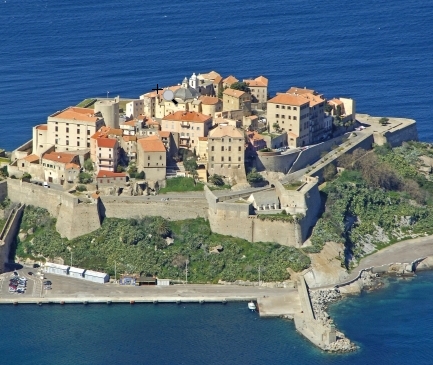
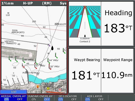
If you read Power & Motoryacht, you may have noticed a contest we’re running on the last inside page. Each month there’s a beautiful full page photo of a distinctive coastal landmark from the vast archives of marinas.com. Inset is a Raymarine E-Series with screen like the above, only smaller. The challenge is to use the data on the screen to figure out where the landmark is. Well, we’re getting more correct answers than expected and I’m especially curious why because I’m making the screens (harder and harder). So help me out; can you figure out where this lovely place is? Did you do it using the screen, or by searching through marinas.com (for a long time), or some other way we never anticipated? Please email me your answers. By the way, the contest has some nice electronics prizes, but, sorry, the entries for this February edition are closed. If you’re good at this, you could always buy the March issue (try a big bookstore, PMY is not into newstand), or a subscription.
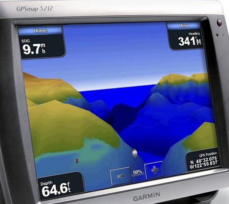
Garmin has put up more press images of the 5xxx series, and this one shows some of the neat 3D abilities I saw demoed in Miami. These machines, and I’d guess at least the 4xxx series too, can overlay radar imagery onto this “mariner’s eye” topside view, and fishfinder imagery onto the separate “fish eye” 3D view. And I don’t mean ARPA targets and fish icons, though they can be useful too. There’s a handsome engine screen too (if you have a NMEA 2000 talking engine, or can use Maretron’s conversion box). The demo units were very much prototypes so I have no idea how fast and smooth they’ll be in real life (actually I’m not even positive which 3D view that is), but they certainly seemed bright, especially for touch screen. I’ve also learned that these 5000 series machines can support a wireless mouse and remote control (4000 series too), which may mollify those folks worried that the touch screen will be hard to work in bouncy conditions. (And I tried faking the Harmony remote into “learning” one of these remotes, which I’m pretty sure it can do). But all this is really just glimpses of Garmin’s new high end; time, and some testing I look forward to, will tell.
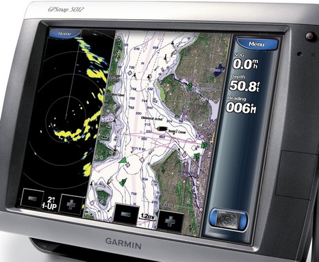
Now it’s real—or at least officially announced and supposedly shipping in June. Garmin went “no comment” when hints surfaced of the 5000 touch screen series six weeks ago, but here’s a picture (bigger here). The specs on the four 5000 models are very similar to the already much anticipated new 4000 series, except for the touch screen interface. (Which Garmin seems fully committed to; I only see a single power button that casing.) This developement would make my PMY prediction—that Garmin’s Miami booth will be very busy—even truer…if it weren’t for a monster storm messing up many travel plans.
Also here in Miami, Faria will introduce the “Maestro Touch Screen Navigation and Command Center” (at Booth G65). I got a preview of these 8 and 12 inch units last month, and think Maestro is big news. The key is a Maptech’s really refined touch screen nav software combined with Faria’s skills at manufacturing and at interfacing with all sorts of engines and other gear. If you make it to Miami, check out Maestro (and, heck, the touch screen Northstar 8000i too, which I’m told is finally shipping in quantity). The year of touch screen?
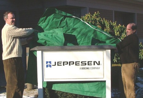
As noted earlier today, the deal went down. Above is the scene this morning at C-Map USA’s Mashpee, Massachusetts, office as Operations Manager Chris Cox and General Manager Ken Cirillo unveil their new sign. Similar events took place at other C-Map offices around the world, and a press release went everywhere. The latter is a bit vague, but a Jeppesen spokesperson at the Denver headquarters gave me a little more color on what this acquisition may mean to marine electronics. The most specific item is that Jeppesen Marine’s recreational division, i.e. Nobeltec, will be integrating C-Map cartography into its products, though it may take six months or more, and the fate of Passport Charts is “yet to be determined”. Otherwise C-Map will be “business as usual”—i.e. same partners, sales outlets, and customer support facilities—at least during the six months it will take to integrate the company into Jeppesen. And the notion that C-Map’s hardware manufacturing facilities were not part of this deal, posted here back in August, was also confirmed. As for that distinctly non-marine logo, the spokesman said they are working on a new branding scheme, but it’s hard to give up the plane after such longterm success serving that market. In fact, Jeppesen supplies 80–85% of commercial aviation operators with not just cartography, but weather, routing, and other essential data. At one point, the company printed two billion sheets of paper per year (!), though now, of course, this data has largely gone digital. Jeppesen is obviously an aviation powerhouse (and so was C-Map in the marine world), which is why the ad they’ve been running in some of the commercial marine magazines—now modified for C-Map’s home page—has weight. It reads, “What happens when a company with more than 70 years of experience pioneering navigational and operational information management solutions for aviators enters the marine market?…The game changes.” But, despite the hints, I guess we’ll have to wait to see exactly how.
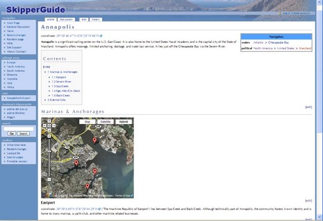
If you followed my PS’s to the ActiveCaptain entry, you know that the site got quite a drubbing on certain forums and newsgroups, much to the amazement of people like me who actually know AC’s proprietors. Oy! But those threads did lead me to check out some other sites that allow cruisers to create/review POIs for each other. I was somewhat familiar with Marinas.com, but didn’t realize that it has by far the best aerial photography of my homeport I’ve seen anywhere, in fact great photography of ports and lighthouses all over the planet. Registered users can write reviews of marinas but there’s no way to correct marina data, which is too bad as a lot of it is flawed. For instance, the flat statement that “The Camden Yacht Club is private, but may be able to offer reciprocal privileges to members of participating yacht clubs” is flat wrong; the Club is welcoming to all cruisers. SkipperGuide is quite the opposite of Marinas.com; it’s very light on content, so far, but users can potentially add almost anything they want, in “wiki” fashion (which it is). In fact, it’s possibly too ambitious; whereas SkipperGuide attempts to cover the whole world of cruising, starting without even a flawed database, it’s going to take a lot of user input to make it seem at all useful. Check out Annapolis, for instance. On the other hand, this site—like the interesting online waypoint, and more, manager POI66–integrates with Google Earth. Are there other sites like this? Will one become the “ebay/Amazon” of marine POI reviews?


 .
.