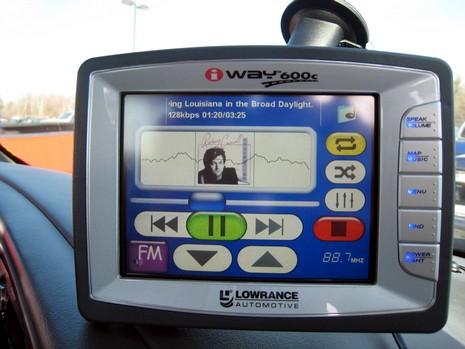
I’ve been using this iWay 600c for a couple of weeks now and there’s a lot to like about it. The turn-by-turn car navigation is first class, and so is the MP3 player. I can’t remember which software I used to rip that Rodney Crowell album, but I just dragged the folder onto the iWay’s hard drive and it took care of the rest, displaying the album cover and track names while sending the sound to my truck’s radio via its FM transmitter. This is not ideal in terms of audio quality, but it’s wirelessly simple and it helps a lot that you can easily adjust the frequency used (those big touch screen arrows at the bottom above) as you drive through sometimes competing broadcast stations. And if you’ve programmed in a destination, or a series of destinations—all pretty easy with excellent Navteq street maps, millions of POI’s on the hard drive, a decent screen keyboard, etc.—the iWay smoothly mutes the music before it delivers voice directions. The navigation/music player combo is pretty slick, and I can easily imagine using it on a boat, at least as a backup plotter. More on that soon.
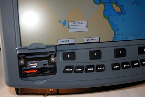
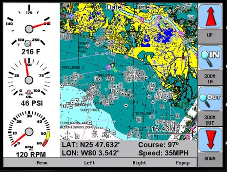
I may abstain from off-the-cuff product comparisons for a while! But whereas I’m already in trouble today, I will express my very mixed feelings about the ColorMax 15, which I actually tested. On the one hand, it’s a notable value—a big bright marine multifunction display with a fast processor and a lot of connectivity going for a street price of about $2,100. This unit may not have a standard Ethernet port, but it does have five NMEA 0183 I/O ports, some of which can be set up (see above) to interface with optional sonar and radar sensors (which may in fact talk Ethernet). It also has two USB ports, seen below, though no stated use for them at this time. That photo is also meant to show that the ColorMax may not dim down far enough for night use in some wheelhouses (without a funky fix I’ll cover one day). But what the unit really lacks is a user interface that takes good advantage of the generous screen space and I/O possibilities. For instance, as noted already in PMY, the only way you can get that four way split shown in the promo photo is to have both radar and sonar attached; you can’t even have two chart windows, let alone the sort of page, window, data box, etc. flexibility seen on most multifunction displays these days. Which brings me to this possibly naive idea: if Si-Tex were to open source a stripped down version of this machine’s code, maybe some amateur developers, and/or small resellers, would make it sing?
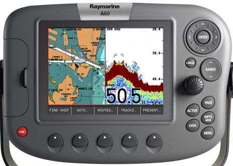
It seems a bit unusual that the folks at Raymarine just announced a new A60 plotter/fishfinder that they didn’t mention at the Miami Boat Show, but I imagine they’re hustling to meet the Garmin juggernaut. After checking out the A60’s specs, and manuals (where I snipped the diagram below), I’d say it’s a worthy competitor to, say, the Garmin 545s. You get a slightly bigger display, 5.7” over 5”, a killer digital fishfinder, and Ray’s C/E-series soft key interface made even simpler as it’s stripped of radar, AIS, wind, and other elements the hardware doesn’t support. The A60 comes with a Navionics Silver card covering all U.S. waters in almost complete detail, plus you can use Gold or HotMaps fresh water cards. The Garmin, of course, has BlueCharts built in, plus you can get g2 Vision cards with hi res photos and 3D, even add XM weather, but is a 5” screen big enough for that sort of use? (Though note that the 545 sports high pixel density, 480 x 640 versus the A60’s 320 x 240.) At any rate, there’s already a discussion going at The Hull Truth comparing the Garmin with Raymarine’s A65, the similar 6.5” model that preceded this new one (at a significantly higher price). But, watch out, I think FlipFlop425’s post is wrong about the 545s having a digital fishfinder. (And, by the way, are any of the new Garmins shipping yet?)
PS 4/18: Yipe, I made mistakes above! It turns out that the internal fishfinder in the Garmin 545s does use digital signal processing, plus you can use its CANet port to connect to an up-to-2kW GSD 22 module. Also, it and the other smaller new Garmins are now shipping (with the 4000 and 5000 series soon to follow). Apologies to FlipFlop425 and also to Garmin’s media guy (whose Blackberry jukeboxed when it started working again early this morning!).
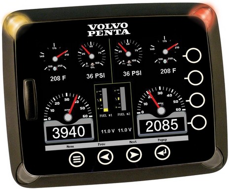
My April PMY column about Charles Industries, and isolation transformers specifically, is now online. Also up are some new product write-ups meant, in part, to illustrate how companies that traditionally supplied engine and boat manufacturers are now making plays for helm space and consumer attention. One is instrument maker F.W. Murphy, whose HelmView is seen above as part of Volvo Penta’s EVC system but is also capable of chart plotting using its SD slot for Navionics cards (below). This puppy can handled three simultaneous CANbus connections, including NMEA 2000, as explained here, and at the Murphy site (and also as used aboard a Cruisers Yachts 447). HelmView’s retail price is not trivial, but it might make a super geek gauge. I also covered Charles’ new IMcharger series, which has optional helm display and/or N2K output, electronically controlled fuel tank selectors from Parker Fluid Control, and a nifty BilgeWatch8 monitoring system that I still have in the test lab, and will expand on here one day.
Moments ago Garmin announced that it has acquired Nautamatic Marine Systems, the inventors and manufacturers of what’s arguably the most innovative autopilot system out there. When I first profiled the TR-1 Gladiator in a 2004 PMY column I noted that breaking into this niche has to be really hard as experimentation and testing are difficult and reputations are built over decades. Hell, I think even the Furuno NavPilot has gone slowly, despite the great name and what I understand is very good performance. At any rate, Nautamatic stuck with it, eventually began to prove its technology, and—yeehaa!—just made the big leagues. Naturally a Gladiator autopilot is going to be a lot more attractive as part of Garmin’s already ambitious Marine Network, both to individuals and boatbuilders, and I wouldn’t be surprised if Garmin engineers help Nautamatic shine up its user interface a bit (though the “Shadow Drive” feature needs none). Of course, the bigger picture here is that Garmin—obviously intent on going toe to toe with Raymarine, Navico, Furuno, etc. over serious recreational boat electronics—just stepped a dite closer, ramping up a competition that I think is good for all of us. It’s also ironic that today I’m finishing up my PMY feature on ideal electronics systems! At least I recommended designing such a system so that it is easily modified or even replaced.
Magellan has not been doing much in the North American marine market recently, and actually this new CrossoverGPS comes loaded with street maps and topos, but you need to purchase pretty pricey chart SD cards to use it on a boat. Nonetheless that little 3.5” touch screen appears to be quite able (don’t miss the demo). I’d like to test it versus the Lowrance iWay 600c, supposedly heading my way for delivery next week. Have a fine weekend!
I’m hesitant about using Panbo as a bug list, but, geez, I’ve been getting bombed with bug reports. So, here goes:
It seems that some or all Icom 802s, almost undoubtedly the premier SSB marine radios, have a clipping problem as noted here at Lectronic Latitude, and here at Icom itself.
A reader reports that his Raymarine E-Series Sirius Weather system messes up some NOAA buoy reports, specifically showing oddly high wind speeds. I don’t have a link to this but have seen correspondence with Raymarine which admits that it is their problem, not Sirius’s, and promises “to address it in a future E-Series software release” (which is less aggressive that the reader would like).
Another reader reports another weirdo: apparently some older Garmins stop sending valid NMEA messages at 23:59:59 GMT. Pascal and others are on the case at rec.boats.electronics. I also got some graphics from a Panbot which showed how a certain BlueChart v8 Bahamas chart was out of whack, putting the routes he’d carefully collected on a Blue Chart v6 into foul waters. They are worth an entry one day to reinforce the point that more than one navigation source is always a good idea!
Finally, the latest version of MaxSea apparently refuses to open virtual com ports created by the Bluetooth protocol stack, according to ShipModul which makes a nifty BT equipped multiplexer (I’ve been trying). Older versions of MaxSea supposedly do not have this problem.
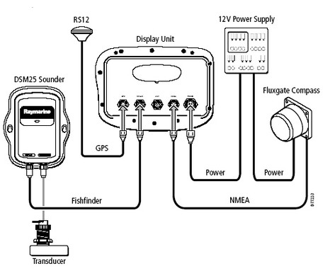
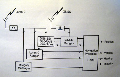
I’m sure I haven’t investigated deeply enough, but I’m mystified by Si-Tex’s eLoran, and maybe you can help. I got excited about the eLoran when first announced, then discouraged that, according to Si-Tex, it only works with their charting systems and P-Sea WindPlot software (primarily for commercial fishermen). Supposedly other companies could develop eLoran compatibility, but none have, as best I know. Then I actually plugged a borrowed eLoran into a laptop running Coastal Explorer and was a bit surprised to find it delivered both GPS and Loran heading information no problem, and might have given a Loran fix if CE was able to convert TD lines to Lat/Long. But maybe not, as that NMEA 0183 LCGLC Loran position sentence seen above may not be kosher. Then I plugged the eLoran into a Si-Tex ColorMax and while it gets a good GPS position, the Loran heading doesn’t seem to work. and I can’t tell if its getting Loran TD’s (the manual doesn’t even mention eLoran), let alone the sophisticated features like RAIM (Receiver Autonomous Integrity Monitoring) described in the eLoran manual (diagram below) . At any rate, I’m talking with Si-Tex technical support, but maybe some of you would check out the eLoran’s NMEA output. A log/text file is downloadable right here. Do those sentences make sense? Any chance you cab feed the data into a charting program or plotter, and see what happens?
PS Today I got a Franson GPSGate log file of eLoran NMEA for download here. While GPSGate is a terrific program, it will not play back this file; another mystery. But maybe someone can find a program that does?
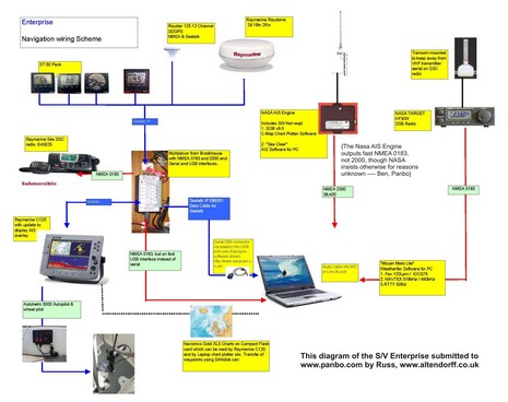
We didn’t get a lot of submissions to the Ideal Marine Electronics project last week, but all are juicy. I’m particularly tickled with this diagram, sent in by an English sailor who writes his own blog with some good m.e. content. There are a few items that I still don’t understand, or may be mistakes, but if you look at the full image here, you can quickly see what gear is aboard Enterprise and how it works together. Go here to see the latest submissions, and then try to top Russ with a graphic explanation of your ideal system. Thanks!
You don’t have to hang around old salts too long to realize that many consider radar to be the primary electronic navigation tool (even before solid state performance), but I’ve wondered for some time if that wasn’t somewhat an artifact of the days before good chart plotters, not to mention AIS. I don’t mean that either replaces radar, but it seems to me that the primary nav tool has become the multifunction display (which even a lil Lowrance can be these days). Here’s some thinking along similar lines from that old salt Milt Baker:
“A friend with a Nordhavn 62 asked me whether I saw advantages to installing a 20 or 25 kW radar in his boat as opposed to a 4 or 6 kW radar. Of course, everybody knows that more is better. Or is it?

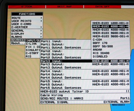
 It also has two USB ports, seen below, though no stated use for them at this time. That photo is also meant to show that the ColorMax may not dim down far enough for night use in some wheelhouses (without a funky fix I’ll cover one day). But what the unit really lacks is a user interface that takes good advantage of the generous screen space and I/O possibilities. For instance, as