
Si-Tex eLoran, some mysteries

I’m sure I haven’t investigated deeply enough, but I’m mystified by Si-Tex’s eLoran, and maybe you can help. I got excited about the eLoran when first announced, then discouraged that, according to Si-Tex, it only works with their charting systems and P-Sea WindPlot software (primarily for commercial fishermen). Supposedly other companies could develop eLoran compatibility, but none have, as best I know. Then I actually plugged a borrowed eLoran into a laptop running Coastal Explorer and was a bit surprised to find it delivered both GPS and Loran heading information no problem, and might have given a Loran fix if CE was able to convert TD lines to Lat/Long. But maybe not, as that NMEA 0183 LCGLC Loran position sentence seen above may not be kosher.
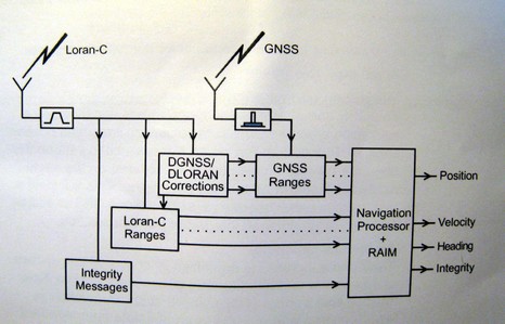
Then I plugged the eLoran into a Si-Tex ColorMax and while it gets a good GPS position, the Loran heading doesn’t seem to work. and I can’t tell if its getting Loran TD’s (the manual doesn’t even mention eLoran), let alone the sophisticated features like RAIM (Receiver Autonomous Integrity Monitoring) described in the eLoran manual (diagram below) . At any rate, I’m talking with Si-Tex technical support, but maybe some of you would check out the eLoran’s NMEA output. A log/text file is downloadable right here. Do those sentences make sense? Any chance you cab feed the data into a charting program or plotter, and see what happens?
PS Today I got a Franson GPSGate log file of eLoran NMEA for download here. While GPSGate is a terrific program, it will not play back this file; another mystery. But maybe someone can find a program that does?
Interesting that the UK's Trinity House are experimenting with eLoran at the moment, and that it has been discussed as a part of the UK Governments eNavigation initiative, but that there are rumours that the USCG are going to shut theirs down!