
Magellan Crossover, a so-so AIO PND so far
Aug 30, 2007
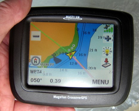
I’ve been intermittently testing this Magellan Crossover for months now, and the fact I haven’t mentioned it here is a sign of my ambiguous feelings about it.
Ben E | Permalink | Comments (3)
I’ve been intermittently testing this Magellan Crossover for months now, and the fact I haven’t mentioned it here is a sign of my ambiguous feelings about it.
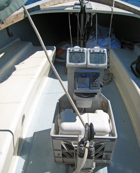
I don’t think I’ll be offered a job in any department at Lyman-Morse, but check out how I turned a milk crate and some wood scraps into Annie G’s new electronics test station. On top are the Tacktick displays already discussed, then there’s the wee Garmin 430, and the secret sauce — hard to see — is a Tacktick T122 NMEA Interface.
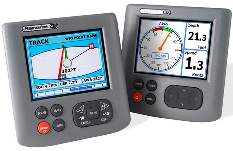
Do these new ST70 instrument and autopilot displays (bigger here) look beautiful or what? The problem is that the screens are probably faked, which is typical of this sort of product photography. But Raymarine assures me that they are gorgeous in reality, and may let me see for myself in a few weeks. The official U.S. unveiling isn’t until mid September but again, darn it, AskJackRabbit got the scoop, first finding some dope in England, then yesterday posting most of what went out to dealers…images, manuals, pricing, etc. Perhaps as noteworthy as rich color screens is the fact that ST70s can not only display NMEA 2000 info, engines included, but can also connect to existing SeaTalk instruments and sensors. Plus they mark the birth of SeaTalkNG (new generation), a N2K-like backbone and T cabling system. More on all after I study up.
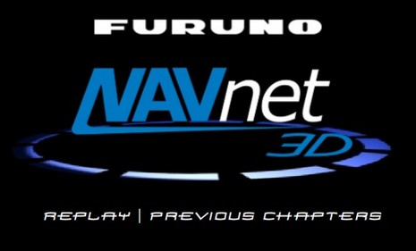
AskJackRabbit got the NavNet 3D scoop, and it sounds interesting. Apparently the hardware is all new, including “digital” radar and several NMEA 2000 sensors (like GPS and weather), but is still backward compatible to some existing NavNet gear. The “3D” angle remains mysterious but Furuno is claiming “You won’t believe your eyes” in a weekly series of video teasers at www.navnet.com, and the ‘lectronic laddies are speculating over at BoaterEd and The Hull Truth.
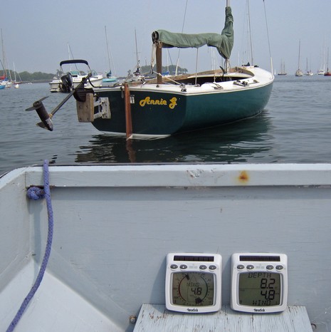
I finally launched Annie G., my Rhodes 18 (named after me mum), and am getting pretty excited about the various Tacktick instruments I’ve installed. I had to drill a substantial hole in the hull just forward of the mast for a T910 triducer that’s wired to a T121 Hull Transmitter mounted just under the mast partners. And I had to modify the old Windex mast-head plate to attach the T120 Wind Transmitter . But I did not have to run a wire down the mast, which would have been a major pain. And of course the T112 Analogue and T111 Dual Digital displays—also wireless and solar powered—don’t need wires either, as I’m demonstrating from my skiff above.
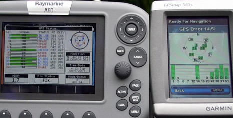
I didn’t get on the water today (my current PMY column alluding to house projects undone is true, worse than implied actually), but I did find a spot down the street that has a decent sky view to the Southwest where the new, and possibly troublesome, WAAS satellite #51 lives. Which is why—if any neighbors are reading—my truck was parked there with three chart plotters running on the cab roof for a few hours. It can take a while for a GPS to find and download WAAS corrections, which probably explains why I failed to see WAAS differential corrections on the Garmin 4212 last Thursday. Garmin assures me that, “As for the new WAAS satellites, all of our newer receivers include firmware that will recognize these new satellites. It might take a few minutes to discover the new PRNs, but they will be picked up eventually.” And the picture above, bigger here, proves it. There’s #51 and all satellites in use are being Differentially corrected.
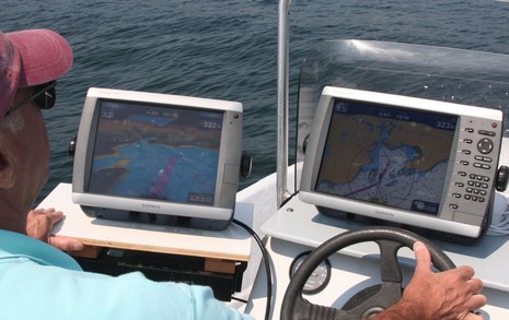
Had some fun this morning, showing my friend Jack the Garmin 5212 and 4212 in action while cruising around a very busy Camden Harbor (classic boat races again). Jack’s no geek but has a lot of plotter time, especially on Garmins, and he really liked these new machines, even the Mariner’s Eye 3D view. Now you will see on the bigger image that there are lots of fingerprints on both screens but mostly it’s the photo/sun angle; they weren’t nearly so noticeable in use. Mainly, I think, because both screens are so very bright even in direct sun. The finger prints are particularly bad because some doubter said he bet the screen wouldn’t work if I had saltwater on my fingers. Easy enough to test, and it worked fine!

I just learned that on July 31 (or July 16, according to this Trimble PDF), the FAA decommissioned WAAS satellites 122 (#35) and 134 (#47), and that at least some marine GPS receivers are not able to recognize the remaining two correction-sending birds, 135 (#45 48) and the new 138 (#51). In other words, your plotter may not be showing your position quite as accurately as you’re used to. Take care, and please report in about your WAAS status. There’s a bit of info about this here, and a good explanation of WAAS here. And maybe you can figure out what the FAA is up to here.
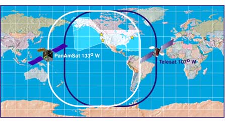
PS 8/4: I’ve added the WAAS satellite service numbers—the # you should see on your GPS’s status screen—to the “PRN” numbers cited above and in the technical notices. Learning those numbers (thanks to Wikipedia) means that the Garmin GPS17 I tested yesterday was seeing the latest #51 satellite, which is the Telesat in geosynchronous orbit at 107W, and may be the only bird visible way up here in the Northeast. #48 is the PanAmSat at 133W and together they are supposed to give most of the U.S. redundant coverage. I still don’t know if the Garmin was actually receiving WAAS corrections. Nor am I convinced that a possible lack of WAAS makes much difference to marine navigation, given how good the uncorrected signals are.
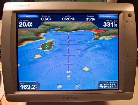
Um, speaking of 3D (and one very funny man), I just unpacked and powered up a 5212 and…wow! On first impression I’d say its touch screen control is as smooth and responsive as Maptech’s latest i3 (and that’s saying something). And weren’t there some nice surprises during my first hour. I’m not sure I’m ready to navigate without spot soundings, but Garmin’s Mariner’s Eye 3D (g2 Vision card required) is darn close. Note, bigger picture here, how you can specify hot colors for the hazardous areas. (The ledges at about .4 miles, two o’clock, should show hotter, but maybe that’s just a local glitch. Will check.) Note too the yellow botches of radar overlay; they’re just a simulation here but I’d sure like to see how they work in reality. (I was monitoring VHF as I tested this unit in the lab. Maine’s blanketed in a dungeon fog this evening, but AIS shows the Cat still doing almost 40 knots offshore; it’s hairy out there!). But what really surprised me is that the two lit navigation aids to Camden were graphically showing their characteristics in this 3D mode (see the green dot over Curtis Island to port). I didn’t even know Garmin had “borrowed” that C-Map Max feature. Now all this may apply to Mariner’s 3D on every new Garmin unit, but the screen below certainly doesn’t. Note the very large touch keys, and note how they’re grayed out when they don’t apply to a particular data field. So easy to use; so sexy time!

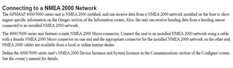
The damn devil is in the damn details. Imagine my disappointment when I hooked a whole network of Maretron sensors into the Garmin 4212---no patch cable needed, much plug'n'play goodness expected---and got NOTHING! I can still scarcely believe it, but when I checked the installation manual, I learned that Garmin is hardly supporting NMEA 2000 at all. The page above says, "The GPSMAP 4000/5000 series unit...can receive data from a NMEA 2000 network...to show engine specific information...Also, the unit can receive heading data..." That seems to be it; no other standard data understood, and no data going out. Garmin even screwed up plug'n'play, for some reason needing "Device Instance" and "System Instance" specified, which I've never seen before.
In short---aside from using the right connector, and the right name---Garmin is not even close to supporting NMEA 2000 in the way we've come to expect from Simrad, Raymarine, Lowrance, and others. I am so disappointed.