Garmin NMEA 2000, not really!

... written for Panbo by Ben Ellison and posted on Jun 8, 2007

Garmin N2K(2)

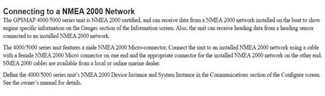
The damn devil is in the damn details. Imagine my disappointment when I hooked a whole network of Maretron sensors into the Garmin 4212---no patch cable needed, much plug'n'play goodness expected---and got NOTHING! I can still scarcely believe it, but when I checked the installation manual, I learned that Garmin is hardly supporting NMEA 2000 at all. The page above says, "The GPSMAP 4000/5000 series unit...can receive data from a NMEA 2000 network...to show engine specific information...Also, the unit can receive heading data..." That seems to be it; no other standard data understood, and no data going out. Garmin even screwed up plug'n'play, for some reason needing "Device Instance" and "System Instance" specified, which I've never seen before.

In short---aside from using the right connector, and the right name---Garmin is not even close to supporting NMEA 2000 in the way we've come to expect from Simrad, Raymarine, Lowrance, and others. I am so disappointed.

Comments

I'm planning two major electronics upgrades at the moment. I have and have used lots of Garmin equipment and like it a lot but had not considered their earlier systems because of lack of NMEA 2000 compliance and compatability. I was strongly considering the 4000 series, on the understanding (similar to yours) that they had finally decided NMEA 2000 compatability/interoperability was the way to go.

I hope what you've found does not indicate Garmin's intent to maintain a substantially closed network infrastructure but, rather, is just waiting for a firmware upgrade to achieve full compatability. That's my hope...but at this point I'm not optimistic.

These are smart people with a successful business. But failure to support standards and allow the user to select peripheral equipment to be supported by central MFDs is very short-sighted.

Posted by: Richard at June 8, 2007 12:37 PM | Reply

A vendor can get NMEA2000 certification with such limited functionality. What does that say for the certification process ?

Posted by: Anonymous at June 8, 2007 1:16 PM | Reply

Has Garmin decided that N2K's usefulness ends with engine instruments? That could only be a marketing decision; short sighted by definition. Its only a question of time before a chartplotter can depict local wind and current information, and use the data to recommend the most efficient routing, or the best tactic on a race course. So unless Garmin has some ultra secret development going on, when that happens, Garmin will have to rely on someone else's instruments and transducers to keep up with the competition, and they will be sending a lot of customers to the competition to buy those instruments. If they can fully integrate N2K on their displays, they will be forcing the competition to invest some major development bucks to cover that move. It almost seems that it would be in Garmin's best interest to trump Nmea 183, Seatalk and Navnet by nurturing N2K.

Posted by: Sandy at June 8, 2007 7:19 PM | Reply

Well, I have to say that I was getting excited by all these new Garmin products coming out. No NMEA 2000 though??? What gives?

Posted by: Eliboat at June 8, 2007 7:42 PM | Reply

Great site! I'm considering the 5012 or the 4012, but I have a few questions that I'm hoping your future review will answer;

1- I heard a rumor that these new units will read one of the 3rd party chart formats. Is this correct? If it isn't I almost certainly won't buy a Garmin.

2- Which would you recommend for a sailboat's cockpit chartplotter, 4xxx or 5xxx? Will the 5's touch screen be worth the extra $s. Or will the lack of buttons just introduce more more problems?

Thanks! Again, great site - I've found it to be a fantastic resource.

Posted by: Joshua at June 8, 2007 11:14 PM | Reply

Joshua, I haven't heard that rumor and very much doubt it. I don't think any other manufacturer offers a choice of chart card types (except Lowrance), so what is your alternate choice?

Posted by: Ben at June 9, 2007 10:54 AM | Reply

Furuno already have a N2K box that will allows navnet to integrate with N2K anyway

weather the idiots decide to release it is another matter

Posted by: Colledge at June 9, 2007 6:29 PM | Reply

Furuno NavNet allows you to use C-Map or Navionics (must specify at time of ordering though due to c-map licensing)

Posted by: Murray at June 10, 2007 4:14 AM | Reply

Colledge-
Do you see the irony in your statement:
"weather the idiots decide to release it is another matter"?

Posted by: Arnie at June 10, 2007 9:09 AM | Reply

I *believe* you can change the chart type (C-Map or Navionics) on the NavNet2 systems. If I remember correctly, it needs to be done at an authorized dealer but it isn't that big of a deal. Of course, there is likely the obligatory fee(s) :-)

Colledge: What box does Furuno have that integrates with N2K? I had heard rumors about N2K compatibility with their future NavNet3 stuff, but nothing about an integration box for NavNet2 or earlier. It would be of great use to me on my Maretron/Simrad/Furuno boat! :-)

Posted by: Tursiops at June 10, 2007 11:20 AM | Reply

currently no interface box is publicly available for NN / N2K

They have one i know a techie at furuno told me have had it testing in Japan and Europe the question is do they release the box and make NavNet non property or not hency why i said if the idiots decide to release it

And yes the NavNet units are electrically idential but have different software in them (no reason why they couldnt accept both apart from c-map licensing laws)

Posted by: Colledge at June 10, 2007 5:34 PM | Reply

Having thought about it for a while, it seems that Garmin should be able to implement at least the reported data from other N2K sentances in upgrades*, unless they have hit a ceiling in the onboard processor or ram. If that's the case, we won't see competitive enhancements until a new series is introduced, which could trash the resale values of the 4000 and 5000 series 'MFD's. The ghost of the G-chart fiasco is ratting its chains....
* It wouldn't take a lot of overhead to put up a simple text screen parroting the user's selection of other available data, as is the case with the AIS data depiction. Using the data or even displaying it on the charts could be a whole 'nuther ballgame.

Posted by: Sandy at June 10, 2007 8:26 PM | Reply

I've had enough frustrations with mediocre proprietary firmware. I think its best to leave the hardware (sensors, antennas, transceivers, controls) to the hardware people and the software to the software people.

Most of the exciting stuff these days is happening with software that runs on a laptop or low-power desktop platform and is always being extended. Platforms like mini-itx may draw a little more power, but at least you're not forced to discard an entire proprietary MFD when you want to get the next release of the software. I've been screwed by Garmin enough times with their awful BlueChart DRM to never want to buy anything from them again.

GPSNavX, the Capn, Fugawi, Nobletec, Rose Point Coastal Explorer, etc, etc, are where it's at these days. (sorry if I left a few out) Eventually people will begin thinking twice before dropping $2k on a planned-obsolescence MFD. Companies like Garmin sure don't seem to care about this stuff piling up in landfills after the resale value has been needlessly obliterated.

The holy grail is going to be when someone gets an open source navigation/radar/AIS/sonar/NMEA2000 project under way. Wish I had more free time..

Posted by: Aaron at June 10, 2007 11:11 PM | Reply

There is no licensing issue with C-Map, the operating software for C-Map and Navionics are different. That is why you don't see units take one or the other.
Colledge- Perhaps you should check your grammer or spelling and stop refering to others as idoits. (weather you reelize it or knot)

Posted by: Arni at June 11, 2007 7:29 AM | Reply

Ahmen Aaron.

Posted by: Eliboat at June 11, 2007 11:44 AM | Reply

Repeat Question: A vendor can get NMEA2000 certification with such limited functionality. What does that say for the certification process ? E.g. an implimentation of NMEA2000 that is not only read-only, but partial read-only functionality.

Posted by: Dan (b393capt) at June 11, 2007 1:46 PM | Reply

Responding to b393capt regarding NMEA 2000 certification, I too was discouraged to see that many pieces of equipment on the NMEA Certified equipment list are not fully capable of exchanging data with all other appropriate (GPS from mfgr. A feeding output to autopilot from mfgr. B)equipment on the network. I have asked the NMEA for clarification.
Charlie

Posted by: CharlieJ at June 12, 2007 7:51 AM | Reply

Leave a comment