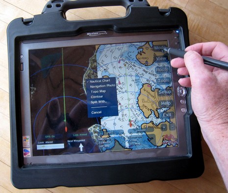
Ever seen this software before? Yup, that's the same touch screen navigation program that Maptech started developing as the Sea Ray Navigator (SRN) back in 2001, and also sold as part of its own i3 hardware system. Well, things have changed. You still can't buy the program by itself, but Captn Jack's is now offering Maptech Navigator Touch Screen, as it's called, bundled with a Motion tablet PC, and will soon also offer it on a Samsung UMPC (maybe the Q2?). I tried it on the Motion above (bigger picture here, and note that the tablet is inside a splash proof case), and found that it worked darn well with the stylus (though, as discussed recently, I think it will be even better when you can use either finger or stylus). In fact, damn slick with the included EMTAC Bluetooth GPS and non-marine software. (I also tried Maptech Navigator Pro on the tablet and, as fine a program as it is, I found it awkward to use with a stylus.)
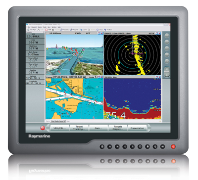
Thanks to Richard’s sleuthy comments to the earlier G Series entry, here are some low res images of various G Series system components beyond the monitors. They’re snitched from an online price list (PDF) put up by French Raymarine distributer SD Marine. The text is in French, and not detailed, but I gather that the “Processeur” GPM400 above has a hard disk pre-loaded with Navionics Platinum charts for one large region—you choose U.S., Europe, or ROW (rest of world)—and Gold charts for the others. It also has dual DVI monitor outputs (1280x1024 pixel), two NMEA 0183 i/o ports, a SeaTalkNG/N2K port, and a 100mb SeaTalkHS/Ethernet port.
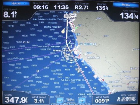
Here’s an entering Portland, Maine, screen photo, bigger here, designed to make a few points re: our discussions of the Garmin Guide To feature and the way the big units display data. This is a Combinations screen and it can have one to four windows with most anything in them, plus the Data Bar if you want. Unlike the largely pre-configured dashboard style data on a regular chart window, you can put any number in the system on that bar. On the 5212, you just touch the field to get list of choices; on the 4000 series you just punch one of the softkeys.
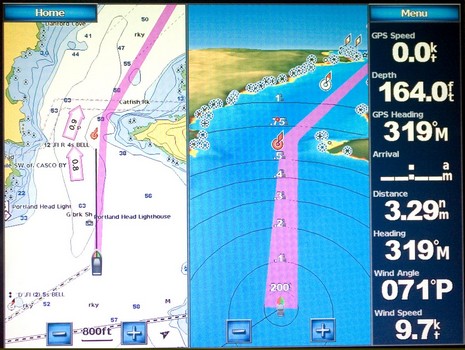
Last week I got a call from Phil, who’s cruising his Tayana 55 down the West Coast, headed for Mexico and beyond. He “loves” his new Garmin 5212, except for an interfacing bug that he’s hoping someone (Garmin?) can help with. Check the photo above, which shows the standard chart display with its dashboard style numerical data. The way that works is that under the Menu key you have four categories of data that you can set to Show, Hide, or Auto (i.e., show only if there’s appropriate data). I know from my own testing that Phil has the “Navigation” either on Show or Auto and hence is getting the info across the top, which is putting him right on his long SE leg toward San Francisco, 9 hours to go at 8 knots. He’s also put “Sailing” data in auto mode (and has the 5212 hooked to his Simrad instrument system), which is why you see not only wind speed and angle along the bottom, but also the wind indicator around his boat icon. I don’t know if he’s set Wind to Apparent or True (or if Garmin can cope with Ground/True subtleties), but the real question is why the heck is that boat icon headed North?
What’s this…a set of parallel rules that didn’t eat right as a child? Nope, the 7.25” ParaLocks were especially bred for taking the lat/long of a waypoint off a paper chart. Put one edge on any handy vertical or horizontal line, spread the rule to your mark (the finger holes help hold it tight to the chart), use the black knob to lock the spread (which can go as wide as standard 15” parallels), and, bada-bing, you’ve captured a measurement you can then take to the edge of the chart or to a scale in order determine a precise latitude or longitude. ParaLocks also have protractor and ruler marks, and do regular parallel rule work nicely on small chart tables and/or small charts, like the 12” wide Maptech Waterproof Chartbook shown. By the way, despite my role as champion of gee whiz electronics, I still like paper charts (and paper guide books). And though I wasn’t a fan of ChartKits when they first came out (um, a couple decades ago), the current versions are great on bigger boats, while the Chartbooks are handy on small boats. Maptech has been doing good work on the print side. Ditto Weems & Plath in the navigation tool dept. ParaLocks are well made and retail for around $22.50.
This photo, of which I’m especially proud (talk about herding cats!), is also a great example of how well Panbo can work with magazine articles. It’s the opener to my October electronics column, in which—thank you, PMY—I had the support to seriously ruminate about testing these four new Garmins. But here online I can show you the picture in greater detail, and write the long caption it deserves.
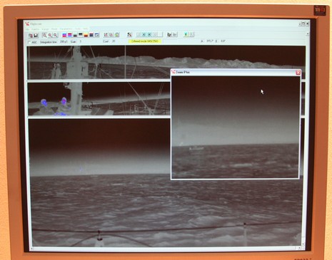
Well then, rounding out a week of gear that you may need a lottery win to own, here’s something quite unusual called Automatic Sea Vision. The camera I saw at METS last year looked different than the one currently showing on the ASV Web site, but I’m sure the idea is the same.
Being a bit of contrarian, I thought I’d put up another high-end display for Panbo’s nattering nabobs to fire upon (just kidding, fellas). Actually, I don’t know what this new RaceVision 3000 costs—B&G is apparently reticent about online prices—but I’d guess it’s a pretty dear 8.4” ruggedized, touch-screen, daylight-viewable tablet PC. The press release suggests that it’s meant to connect wirelessly to a set of instruments—preferably H3000 digitals via B&G’s souped-up WTP2 Processor—and directly to the Web for GRIB file downloads. In fact, the latest 8.2 version of Deckman, which comes preloaded, includes integration with the nifty Ugrib software I tried a while back. At any rate, a full-on race system with a 3000 on deck could really add up.
When Ask Jack Rabbit recently got the goods on Raymarine’s new 12– and 15–inch G-Series monitors, brochures and manuals included, he hinted that perhaps other models or a coming black box would add “storage and processing capacity.” Apparently so, as here’s the “launch” description from the Southampton Boat Show:
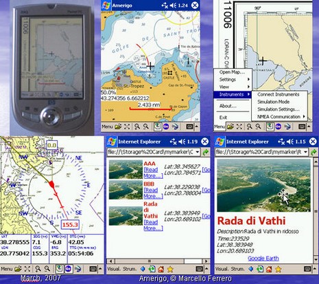
Head’s up, open source programmers. Marcello Ferrero has begun the Amerigo project, navigation freeware meant for PC, PocketPC and WinMobile phones and PDAs. A “PreAlpha” release is out, and Ferrero is hoping some nautical code jockies will join him. One feature that he thinks unique will be the ability to use a Smart Phone with camera to create a photo POI in one click, adding categories and text as desired. But I wouldn’t be surprised to see this sort of feature arrive first from ActiveCaptain’s mobile project, still “under construction”, or maybe EarthNC, or who knows where. Does anyone doubt that Web 2.0 will mash up tight with marine navigation eventually?

 Thanks to Richard’s sleuthy comments to the