
Garmin's "Where To?", what up?
This photo, of which I’m especially proud (talk about herding cats!), is also a great example of how well Panbo can work with magazine articles. It’s the opener to my October electronics column, in which—thank you, PMY—I had the support to seriously ruminate about testing these four new Garmins. But here online I can show you the picture in greater detail, and write the long caption it deserves.
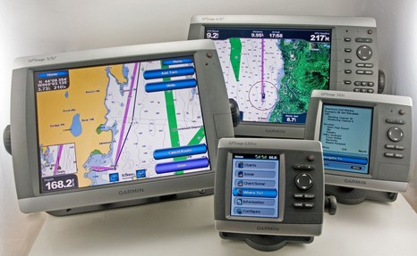
The goal, besides illustrating relative sizes, was to demo the Where To? button that appears on the Home menu of all the new Garmins, seen here on the little 430sx front and center. A major theme of the column is that Where To? is a truly fresh look at routing, and the beginning of the end, I think, for electronic route-building styles that are still rooted in pencil-on-paper navigation (and which many boaters resist using). If I’d had six units (yike!), I would have included the two screens below in the counter clockwise progression. Where To? takes you first to a choice of common destination types (lower left), then your choice generates a list or relevant possibilities ordered by distance from your present location. On the big picture you’ll see that I chose Journey’s End Marina and got back all sorts of info on it. (The 545’s screen is one of 4 available for that particular POI, including a zoomable chartlet, photos, and local weather if XM is on board. You gotta love a marina, by the way, that also sells bait by the tank.)
At any rate, if you decide that that’s where you want to go—the real first question of route planning—then you hit the Navigate To button). The screen isn’t shown but the choices are Go To for a simple straight line course/bearing to the destination or Route To, which puts you at the destination with a “rubber band” route line that you can work backwards to your location, key or finger tapping waypoints as needed. That process is shown in action on the 5212, but if you have a g2 Vision chart card in the plotter (or, as here, in the network), then you might instead choose the Guide To option, seen best on the 4212. Guide To uses the card’s bathy detail to figure out a “reasonable” (usually) route to the destination which it lays down as a purple road. As shown, it gives you distance to, and ETA at, the destination as you drive along it. But, if you want individual waypoints, or to drive an autopilot, you have have to add them rubber band style. It all works pretty nicely, and I’m sure will get better as Garmin continues to develop—you might say, “finish”—the software (another theme of the column). Finally, check out the little window on the left side of the 5212. If you finger drag (or cursor) the chart so that your boat is no longer visible, that little situational awareness chartlet pops up. A nice little (optional) feature I’ve never seen before. See how this caption would be hard to fit in a magazine! (Here’s a list of Garmin entries.)

This is great. The software can evolve so that all routing algorithms use "common" routes to and from popular places. This means that boaters who are likely to use this feature will be herded into predictable lanes, much like VTS.
The possibilities are endless - I can get one so I can know what routes to avoid (sooner or later this will be on charts?), Vessel Assist and the like can study common routes and pre-position themselves where groundings are likely, services can become established along common routes, floating latte stands! The future is near!