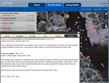
My column about the sorry state of marine Points of Interest (POI) info is now out in the February issue of Power and Motoryacht (and now online). At the end of it I make note of a cool new Web service that was about to go live and that could go a long way toward solving the POI problem. Well, ActiveCaptain.com is really here, and it’s even better than the alpha version suggested. The site was created by the talented Jeff and Karen Siegel, and its goal is to let all of us contribute details of marina services and give them ratings. Other useful POIs, like anchorages, will be possible soon. The Web interface, using Yahoo maps and sat photos, is wicked slick, and totally free. And it will remain free, as the Siegel’s business plan is to develop and sell software that will enable mobile devices like cell phones to easily access ActiveCaptain, while leaving regular Web access free, even of advertising, so that hopefully a critical mass of “captains” will contribute to it. Smart! But there is an ironic twist to this story. My secondary objective with the POI column was to promote my home harbor of Camden, Maine, which has a largely undeserved reputation as a tough place to find a good and reasonable berth. Well, wouldn’t you know it, Jeff Siegel himself was the first person to rate a certain Camden marina and apparently it’s the only negative one he’s written so far! But that’s how it works when when conversations gets real. I’ve already detailed and rated Camden marinas myself (full size screen shot here), and am confident that even what’s there now, week one of ActiveCaptain.com, is more accurate than what you’ll find on any electronic chart or in any guide book. Now there’s probably another dreary winter weekend ahead, so take some time to register at ActiveCaptain and add your two cents about Camden or any other harbor you’re familiar with. The more, the better.
PS, 1/27: Oy, some of the cynics at rec.boats.electronics and rec.boats.cruising have gone paranoid about how ActiveCaptain’s sinister purpose is to “harvest” e-mail addresses. Ignore them! I am absolutely confident that the Siegels will not misuse anyone’s e-mail. By the way, much as I appreciate those newsgroups, they certainly can be sources of misinformation. Interestingly, the ringleader of this particular nonsense is a regular poster/windbag named “Larry”, whose asinine rants about NMEA 2000 already made Panbo. Always ignore Larry!
PS, 1/28: Oy again; the righteous moderators at SailNet even axed a simple announcement of ActiveCaptain. Isn’t it ironic that if the Siegles had included an obvious revenue source like Google ads on the site, these paranoids would probably be excited about it? Haven’t they noticed business models that include a significant ad-free element, like, say, GoogleEarth?
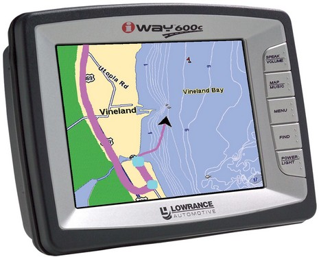
The Lowrance press release claims that “the iWAY 600c is the first portable navigation device to offer dual routing capability, allowing consumers to navigate both highways and waterways”, which I don’t understand as Garmin has done that nicely for some time. But that’s not to say that the 600c isn’t an interesting and unique portable-sized car/boat navigator. How’s about a 30 gig hard drive almost filled with U.S. and Canada road maps, hi res sat photo maps of metro areas, 5.5 million POIs, Lowrance’s own NauticPath U.S. charts (hopefully fixed), and some 3,000 Enhanced U.S. Lakes (there is a European model too). Which leaves 5 gigs free for MP3 tracks you can play using the unit’s built in “full spectrum FM modulator.” All is this displayed and controlled by a 5” VGA touch screen for $800 list with 12 and 110 power supplies, suction mount, and USB interface included. The 600c does come out of the automotive division—which is probably why I didn’t hear about it until now (thanks, Barry!)—and while the press release says “waterproof”, the spec page says “completely sealed to prevent internal corrosion.” At any rate, it’s supposed to ship in February and I’m on the test list.
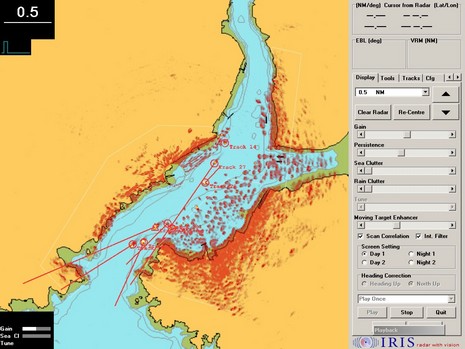
Iris PC Radar is a relatively new product purportedly able to "interface as a slave or display-only with almost any radar antenna, and at present can control Raymarine, Kelvin Hughes and the Simrad/Koden/Anritsu family...soon to be more". Moreover, "its 8-bit digitization gives far superior picture quality and sea clutter performance compared to ordinary boat radars", and it incorporates a target tracker with AIS input and S-57 chart overlay (screen below, bigger here). Iris is currently marketed for harbor surveillance and is also integrated into the interesting monitoring and control system FT NavVision, but--head's up, integraters and developers!--owner Ledwood Technology is "looking for partners to sell and continue to develop the radar." My sense, by the way, is that 2007 is going to be a significant year for marine radar.
I still maintain that shutting down the Loran system is a red herring, but the USCG has asked for comments on the subject, and hands are wringing. Here, for instance, is a short piece called “Loran’s Last Chance?” on AVweb. Follow the link where the author writes “The UK has a similar [Loran] system and is also pondering whether to keep it or not”. Not really, you’ll find; what the Brits are actually thinking about is building a new eLoran system!
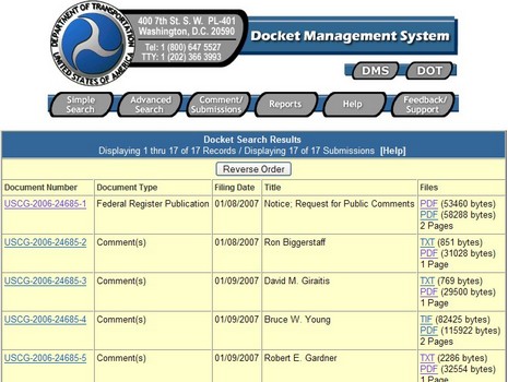
Nonetheless, it seems prudent for any one who wants a redundant electronic positioning system—and you should!—to register their opinion. And the government has made it easy (though not so easy to give you full links). Here’s the drill: go to http://dms.dot.gov and do a simple search for docket item 24685. You should get to the screen above, which gives you access to the Notice itself plus the comments coming in. Unfortunately the TXT versions don’t word wrap, but the PDFs read fine. Try Robert Gardner’s for some good dope, and I’m hoping my own comment, submitted early this morning, will go up soon. Comment Submissions, button at top above, is a really easy form, and very little ID is required. (Nice work, DOT!)
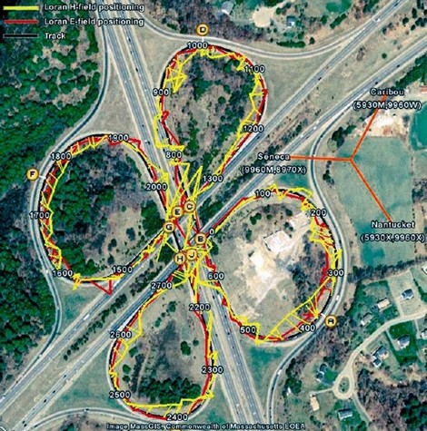
For more info on Loran, the Wikipedia entry is excellent, and it also got me to an amazing PhD dissertation on the subject just completed by Wouter Pelgrum. He’s the guy who got dizzy on a Massachusetts clover leaf demonstrating how accurate even the somewhat improved current Loran system can be. Now, I’m going to do more testing on the Si-Tex eLoran, already looking good; you think about telling the USCG that we need this capability.
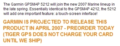
Well, I’ll be damned. Apparently Garmin is also introducing a touch-screen version of the 4000 Series, already hot stuff on several counts. At METS I think I mumbled something about how the new large-label interface would work nicely with touch, but no one even hinted that it was imminent. In fact, there’s nothing on Garmin’s site about 5xxx, but a Google search on “Garmin 5212” finds a number of stores taking preorders, including Tiger GPS above (which also has a useful run down on all the new models). Garmin is clearly not messing around in 2007. (Big thanks to Eric for this tip.)
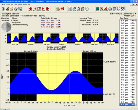
There’s something special about this Nobeltec Tides & Currents 3.5 screen shot, bigger here. Besides some sleek improvements to the interface, the program—targeted for release in early January—is corrected for the new Daylight Saving Time (DST) scheme coming to the U.S. in 2007. Yes, in case you hadn’t heard, we are adding a month of DST, now starting it on the second Sunday in March and extending it to the first Sunday in November (with a few exceptions). That will most definitely mess up any uncorrected software or printed tide tables you use, if they are supposedly adjusted for DST. (NOAA used to print all tables in Standard Time because, according to a functionary I once spoke to, they didn’t know how to handle predictions that fell between 1am and 2am on the last “fall back” day of DST, when that “hour” happens twice). I know way too much about tide tables from my days as ‘editor’ (data dicer actually) at Reed’s Nautical Almanacs. I still use some of the skills learned to make a couple of newspaper tide tables, like the one below (bigger here). There’s a lot of scripting and Quark XPress tag trickery behind that table, but I get the tide predictions themselves using the nifty data export facility of T&C. Note the difference between 3/11 tides above and below: I’ve marked the new “DST begins” on the table but the data is still wrong, awaiting T&C 3.5.
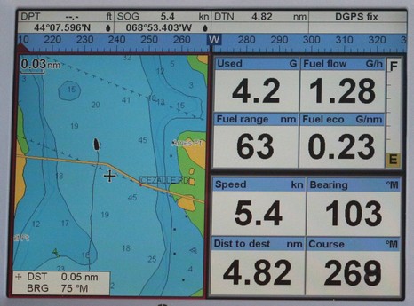
As previewed at METS, the Northstar family has no less than 29 new members, which means that the brand now offers full product suites for most any size boat. Of course most of you won’t even need the bigger image to realize that these are very similar to existing Navman products, only with black buttons instead of blue ones. In fact, my understanding is that most of the 27 ‘new’ Explorer units are exactly like their Navman counterparts, though a few have upgrades like higher resolution screens, and—good news—none have risen in price. The one completely new unit is the M84, at right above, which is an 8.4” version of the Northstar M120, which is essentially the same as the Navman 8120 I’ve been testing. In other words, both of the new M Series units should be able to hook up to either SmartCraft engines or stand alone fuel flow meters to show a nifty screen like the one below (never mind the road shown running over the Fox Island Thorofare—just another one of those chart anomalies we should be on the watch for!). So far only the M84 is detailed on Northstar’s Web site, and I believe that all these new relatives may retain the Navman name in certain countries like South Africa where it’s much better known than Northstar’s. Finally, whatever the name, most of these plotters have recently acquired excellent AIS display ability, to be illustrated in a coming entry.
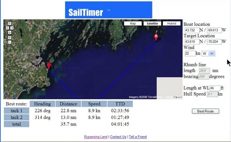
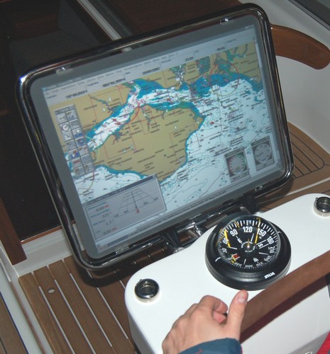
It’s hard to make out until you view the bigger image, but this screen is a Google Map demo of an interesting utility that can guesstimate an ETA for a boat that’s tacking into the wind. It was originally developed as SailTimer, but is now going to be incorporated into a new SailBoat Edition of NavSim’s BoatCruiser. I think that full-on routing modules, like RayTech’s and MaxSea’s, can provide this same sort of real life ETA, based on weather forecasting and a boat’s performance data, but maybe I’m confused? Starting yesterday at the WorkBoat Show in New Orleans, NavSim is also previewing a new version of NavCruiser Pro that uses C-Map Max Pro charts. Prior to this product, the Pro format—which looked very powerful in a presentation I attended at the NMEA conference—was only available on the Northstar 8000i, a system I gushed about last year, but is only now coming to market (there were some problems). At any rate, I flew down to New Orleans today, mostly for a Charles Industries product introduction, but plan to visit the Show tomorrow (anything particular I should check out?). Which is why there’ll likely be no Panbo on Friday, but I may get to see NavSim’s latest.
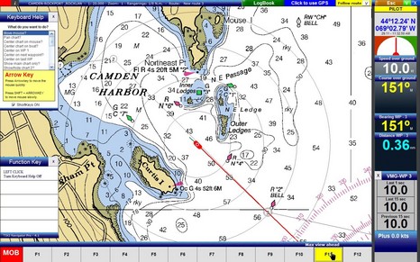
It’s worth checking out this screen shot in all its colorful pixels. Tiki Navigator is slowly gaining a devoted following, largely for its clean and attractive interface. I made this screen show some interesting options like the context sensitive help windows and the function key map, but they disappear completely if you want them to. Tiki only shows raster charts, but otherwise seems to have a lot of features, depending on the version you choose, all reasonably priced.
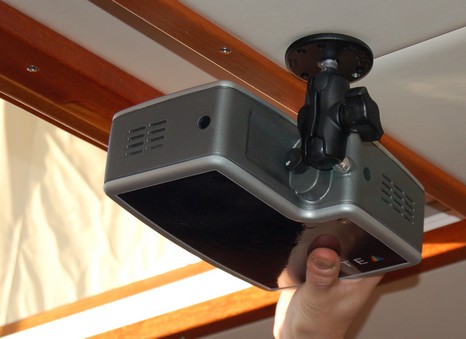
Here’s a novel idea seen at METS: a marinized, 9–28v digital projector (front or back) meant to show multifunction nav data in the cockpit or—just swing it around—a big screen movie in the salon. The potential simplicity, not to mention lack of wires and weight, is intriguing, but I’m sure I’m not the only one wondering if any projector can overcome direct sunlight. (Plus, you know the kids are going to make wolf & bunny shadows on your plotter). My sense was that Optea has not yet put the XLMulti into full production, possibly awaiting investors or partners. Your move!