
The photo contest conundrum, great circles!
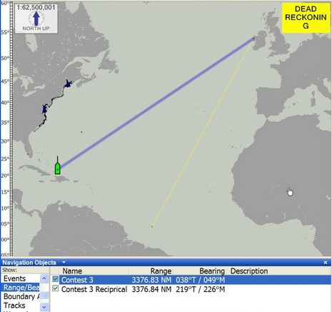
So let’s talk about issues with the last photo contest. My hope was that someone would figure out that the coral patches, steep drop off, and north facing channel had to be in the Turks and Caicos Islands, specifically the entrance to Turtle Cove, Provo. Then you could refine the boat’s location to 21d 47.806’N, 072d 12.453’W (I can’t get this software to insert the degree symbol so I’m using “d”). Then you’d use some navigation software or machine to create a relative waypoint at 039d True and 3,377 nautical miles (off the contest screen), which—ta-ta—would turn out to be Clare Island, Ireland. You can do this on a Raymarine E-Series but I’m not sure where else. That’s because the E is doing its calculations in great circle geometry, which means that the bearing is going to change as you travel along the course.
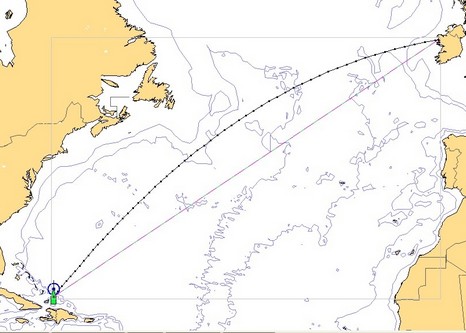
That’s why those people who figured out Clare Island from the photo could not easily use a reciprocal course to figure out Provo. Check the Coastal Explorer screen above. CE seemed to figure out the great circle first bearing/range fine but draws it as a rhumb line instead of an actual great circle route, and trying to use the “reciprocal” puts you down toward the Amazon. By contrast, Visual Navigation Suite can lay out either rhumb line or great circle, shown below. The rhumb line route, by the way, is a constant 57d True for a distance of 3,520 nm. When you activate the great circle route in VNS it gives you 39d bearing to a waypoint 60 nm away, where you may change course slightly right. I presume that CE and E-Series just change the bearing figure as needed. How does your nav system handle long ocean routes?
Thanks Ben for posting the answer(s)
Pat Harman