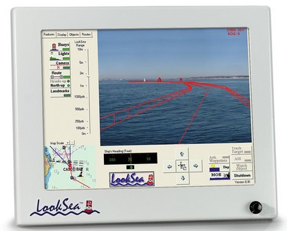
Never mind that Yme covered this Friday’s (mega) gizmo early last year. LookSea is truly unique, little known, and, besides, it was developed right here in the great state of Maine. What you’re seeing—larger image here—are a fenced route and buoy icons precisely superimposed on the video flowing from a pan and tilt, high resolution, wide angle camera mounted on the cabin top. ARPA and AIS targets, charted obstructions, and whatever else you need (and only what you need) can also be geopositioned on the live video. This is damn tricky to pull off accurately, and if it wasn’t done really fast, it would literally make you sick. I saw it demoed in a bouncy little boat on a snotty night, and can tell you that it works beautifully (fat .pdf of my article available here). I second the claim that LookSea is the “only augmented reality marine navigational system available and represents a quantum leap in safety and situational awareness.” It’s darn expensive, but I figure it’s a harbinger of things to come. (LookSea now a good step-by-step demo and other materials here).
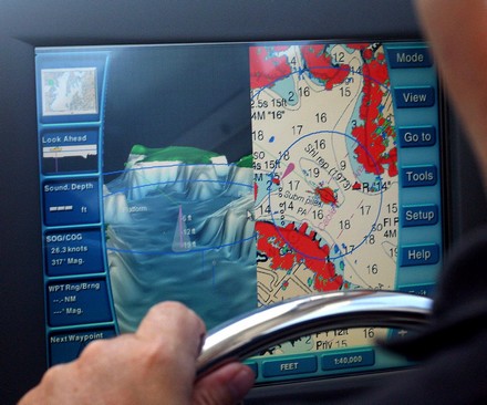
A bonus of my trip to Annapolis was getting to try Maptech’s third generation i3. I first saw this system back in 2001, when it was being developed as the Sea Ray Navigator (and it’s still going on many new Sea Rays under that name, despite parent Brunswick’s own move into electronics). Last summer I enjoyed a live demo of the second generation system, which Maptech had begun to market on its own as i3. By then the developers had added radar plus optional touch screen versions of Weather Channel Marine and SkyMate. Now Maptech owns the contractor that actually builds the i3 hardware, and the new Type 3 is a significant upgrade. The screen is more stylish, more colorful, and brighter, and the software flys. Plus there are many interface improvements (besides the 3D fishfinder option). In the screen above (bigger here), notice how the radar range rings can be shown on the 3D screen to make better sense of relative scales. Notice too how the 3D is automatically exaggerated to make the good, and bad, sections of this relatively shallow river (hey, I live in Maine) obvious. Look at how well the radar is synched to the chart, despite the fact that there is no electronic compass in this particular install and we’re doing 26 knots (which is why the depth sounder isn’t reading; the transducer needed better fairing for high speed). It’s not shown but Type 3 also lets you remove the side menus, or make critical info semi transparent, so you get more chart on the 12” screen. And, finally, there’s now a 15” screen version too. i3/SRN is not just a unique concept; it’s an evolving family of functions.
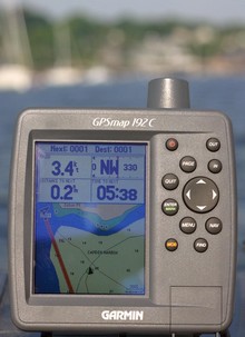
I was out testing in bright sunshine Saturday morning, and the screen on the Garmin 192C stood up very well. In fact this is the worst image I got, and it’s still quite readable (bigger here…note the glare, reflected elbow, and gunk on screen—real world factors you’ll rarely see in ads or articles). The 192 is the new unit that comes with all U.S. coastal charts in memory and ready to use. They really are all there, along with large area charts of places like the Bahamas, a good world map, and tons of port information. It is true that you can not use these charts with Garmin’s MapSource to do planning on a PC, but the no-PC-needed simplicity will be a plus for many users; even updating the charts will be done with a card. The only other con I could detect is that the find function is slowed down somewhat by the massive amount of data it has to search through. Besides the brighter, more color saturated screen, I noticed numerous subtle improvements in Garmin’s already effective tabbed interface. I’d guess the 192 will appeal to smaller boat owners wanting ready-to-use simplicity and flexibility (trailer north or south for vacation, get a card for lakes), not to mention cruisers who do big sections of the U.S. coast and want a backup to integrated and/or PC systems. The 192 comes with internal or external GPSs, and there’s a 198 version with fishfinder. Garmin won’t say if it might bring the all-US-charts-onboard strategy to other models, but what do you think? (Especially as Lowrance is offering this feature on many units).
This weekend’s mail included Simrad’s “Navigation Tutorial” DVD, which is pretty darn impressive. Of course there is some ‘sell’ to it, but there’s also some sharp footage of boats and extensive, well done explanations of just how Simrad’s multifunction Navigators work. (That’s the narrator’s hand in the picture, not mine, explaining dual radar ranges). This DVD is excellent for anyone who owns a Simrad, or is interested in one, and it’s absolutely free, including shipping. The order form is on the Simrad USA home page.
The croakers and rockfish just weren’t biting, but the research trip was terrific anyway. I’ll have more to say later about trying the latest incarnation of Maptech i3 and the Airmar factory tour, both very impressive, but today’s entry is about a little company you’ve never heard of called NSI (Nautical Solutions International). Google can’t find them but principals Mark Pringle and Floyd Phillips have been doing valuable, innovative (behind the scenes) work with 3D bathymetry since 1996. You may have seen it as contour modules in Maptech or Raymarine software, or as Bass Tracker on ESPN (and there’s more to come). Their web site is informative, but doesn’t show you how their office is right next to the marina where they keep two test boats ready to run year round. The latest, the Defiance 260 above, is totally tricked out with i3 gear; besides the big scanner, those are Weather Channel Marine and SkyMate satellite antennas up there. Such a deal: Maptech sponsors a great boat for showing off i3, which the lads at NSI also use to tweak the 3D fishfinder (and take a break from coding). Nice!
I have no tolerance for boaters who rip off electronic charts; the practice hurts decent companies and has understandably led to copy protection schemes the rest of us have to cope with. But one chart manufacturer, Nautical Data International (NDI), has earned its own reputation for pirate practices. It ticked off customers for years with extra high prices, flawed encryption code, and even a “time out” mechanism that rendered charts you owned useless after a certain period. Two years ago, a nasty royalty fight erupted between NDI and the two big chart card companies C-Map and Navionics. You see, in 1993 NDI somehow wrangled not only the exclusive right to market electronic versions of Canadian Hydrographic Office (CHS) charts, but also exclusive right to negotiate royalty arrangements with other vendors. Many lawsuits followed, some still in court, but last winter CHS announced that it would terminate its relationship to NDI. Hence the strange press releases featured on NDI’s home page (right) proclaiming its ability to continue “business as usual” and its success suing the government office it’s dependent on. I bring this up because I recently helped a friend prepare for a Newfoundland cruise and can confirm that charts he bought from NDI five years ago will not run or reinstall on his PC. He will use paper charts rather than ever do business with NDI again.
I’ve been getting requests to show more Platinum screens, so here’s one of what’s called Aerial Overlay. That means you can blend the regular vector charts with photo maps, which are straight down images that have been geopositioned so data (including your boat) can be plotted on them. Here the transparency of the photo map is set at 69% using the rotary knob on an Raymarine E120. Note how the photos improve your knowledge of what’s along the shore. Note too that the blending reveals descrepencies between the vector data and the photo map, a head’s up that one or the other is inaccurate. Platinum seems to include this resolution of photo maps for the whole U.S.; I understand the European version is lower res. Note too the camera icon, which shows you that there is also an “oblique” or “panoramic” photo available for this specific spot (wish we could all agree on nomenclature!). These are not geopositioned but do give you a useful perspective view of important inlets, marinas, etc. In Platinum they are quite high res (example coming).
I like this: GPS backed up—plus made more accurate, even able to deliver better than 1° heading accuracy at rest—with LORAN! And this is LORAN without the fiddly complexity of compensating for “Additional Secondary Factors” in coastal waters or switching ‘Chains’ on long voyages. Si-Tex’s eLoran is not quite shipping yet, but I’ll bet it will get loads of attention (Chuck Husick already has this to say). In fact, we’ve all gotten so dependent on GPS that it’s a little scary. I wrote about its vulnerability, and the possible resurgence of LORAN as a complimentary system back in 2002, and have since noted the government’s funding of LORAN base station improvements. It’s great to see belt & suspenders electronic positioning come to recreational boating, not to mention the non magnetic heading sensor capability. Actually, eLoran is one result of a military research contract executed by Si-Tex’s mother company, Koden. Note that this initial product will only work with certain Si-Tex plotters and PC software at first, but other manufacturers will be free to add compatability. I’ve also been told that eLoran will cost about $1,000, and I plan to try one out when available.
I have an article about Navionics’ and C-Map’s new plotter charts in the June issues of both PMY and Sail, but unfortunately neither is online yet. C-Map Max is shipping and there are good images of it here, but Platinum—which by design, and pricing, is the more ambitious product—is still a mystery to most anyone who didn’t get a chance to see it previewed at the Miami Boat Show. Above is a screenshot of 3D mode, which really should be a video to do it justice. You can see (bigger here) that critical chart data like buoys and wrecks are overlaid on a composite of land photo maps and underwater bathymetry. The soft keys on the Raymarine E120, which will soon be the first plotter to display Platinum, indicate how you can adjust the pitch and rotation of your view. There’s much more. One indication of how much more is the fact that Platinum comes on 2 Gig Compact Flash cards!
Every year I get to pick five especially innovative and/or well executed electronics products for Sail magazine’s February “Editor Picks” section. Right now a top contender is Navman’s AP338 autopilot, not for performance (it’s darn hard to test autopilots) but because its interface is amazing. Almost any pilot can “dodge” an obstacle, usually 10 degrees per button push, but this one actually shows you what the commands are doing to your heading and what you can do next. There’s much more to this interface but I’m working with a flaky WiFi connection this morning, and busy, so for now I’m just going to link you to my writeup in June PMY.

 I was out testing in bright sunshine Saturday morning, and the screen on the Garmin 192C stood up very well. In fact this is the worst image I got, and it’s still quite readable (bigger
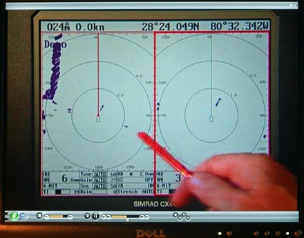

 I have no tolerance for boaters who rip off electronic charts; the practice hurts decent companies and has understandably led to copy protection schemes the rest of us have to cope with. But one chart manufacturer, Nautical Data International (NDI), has earned its own reputation for pirate practices. It ticked off customers for years with extra high prices, flawed encryption code, and even a “time out” mechanism that rendered charts you owned useless after a certain period. Two years ago, a nasty royalty
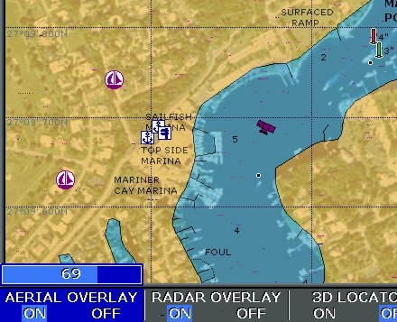
 I like this: GPS backed up—plus made more accurate, even able to deliver better than 1° heading accuracy at rest—with LORAN! And this is LORAN without the fiddly complexity of compensating for “Additional Secondary Factors” in coastal waters or switching ‘Chains’ on long voyages. Si-Tex’s
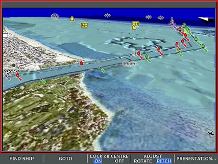
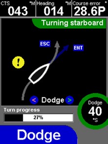 Every year I get to pick five especially innovative and/or well executed electronics products for Sail magazine’s February “Editor Picks” section. Right now a top contender is Navman’s AP338 autopilot, not for performance (it’s darn hard to test autopilots) but because its interface is amazing. Almost any pilot can “dodge” an obstacle, usually 10 degrees per button push, but this one actually shows you what the commands are doing to your heading and what you can do next. There’s much more to this interface but I’m working with a flaky WiFi connection this morning, and busy, so for now I’m just going to