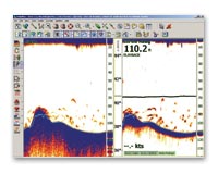
Nobeltec just announced an InSight Sounder option for its VNS and Admiral charting+++ programs. The company can now supply the soft– and hardware for plotting, radar, AIS, and fishfinding, including a heading sensor and even a wireless display. Nobeltec has also established a relationship with SkyMate, the easy-to-use satellite messaging and monitoring system that I’ve followed with much interest. Their respective programs can now share a PC and sensors nicely, and maybe more (not much on either company’s sites yet). Finally, Nobeltec has slashed the price of its AIS listener (was it the first to offer AIS to yachts?), and is running some new rebate programs. And we can imagine that the lads in the lab are working on more ways to expand the total package.
The June issue of PMY includes my take on the Furuno/MaxSea alliance. I titled it “Keys to the Kingdom” because it’s truly a big deal for Furuno to give PC software access to its whole NavNet system. It really shows what Ethernet can do, besides string multifunction displays together, and I’m guessing it will “encourage” Garmin, Northstar, and Raymarine to develop or find PC programs to run with their Ethernet systems. Dedicated electronics and PC-based systems used to be parallel universes (with a few significant exceptions); now they’re coming together. Good!
U.S. Navy Submarine Captain Kevin Mooney takes full responsibility for crashing the San Francisco into a practically uncharted undersea mount in the Pacific last January. Yesterday the New York Times published a detailed story about the accident, particularly the drama of trying to treat and evacuate mortally injured Petty Officer Joey Ashley. Then CBS 60 Minutes did a “Who’s to blame” piece, which I happened to see. The interviewer drew out how Mooney was using a classified, best-available Navy chart and steering a route sent from headquarters, but still the Captain—who seemed like an very decent man—insisted that he should have been going slower, should have checked other charts (where there were just hints of the mountain). Most of all, he said, “I should have been more skeptical about the chart data.”
Those are words to remember, especially as there’s a growing disconnect between our super precise electronic navigation and the precision of the underlying chart data. It’s a phenomenon I wrote about here.
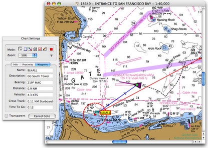
Correspondant Dan is psyched about the growing possibilites of Mac navigation for his 40’ sailboat. The starting point is GPSNavX, which offers a hell of a lot for $50, was extravagantly reviewed by Chuck Husick here, and will soon—according to Dan—support free NOAA ENC vector charts. Possible hardware includes a “Mac Mini, a normal 12-15" monitor for below decks, a sunlight monitor (like certain Big Bay screens sold by Tom MacNeil Electronics) for the helm w/mouse and buttons to control the software on the mini, BSB charts form Maptech, and a Nasa AIS Engine.” He also mentions a Mac compatible USB GPS whose links seem dead, but there are other choices; I like the looks of the USGlobalSat MR-350 cabin top model that can be bought with GPSNavX. Dan closes his description with that favorite Mac brag, “And, best of all: no viruses...” Us PC people are a little jealous about that, and about the Mini, which almost seems designed for a boat.
Seems-to-be-a-trend department: another correspondant, a true Uber Geek, wrote last night describing the elaborate system he’s putting together for a custom 50’+ power cruiser. “The helm support computers will be Mac Minis and the planning software will be GPSNavX, an insane value at $50!!”
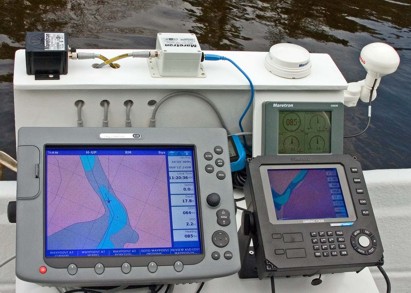
It was another damp weekend in Maine, but the leaves are popping and I finally got out on the water. The NMEA 2000 test rig performed fabulously. Check out the bigger image here to see how the Raymarine E120 and Simrad CX34 are both getting GPS, heading, speed through the water, etc. from the Maretron sensors. A PC charting program could have been easily sharing it too, had I dared bring a laptop along. At this moment I was drifting (speed 0, SOG 2.2; heading 85, COG 64) down the St. George River with…errrr…a rather high level of situational awareness. Both plotters were able to calculate current set and drift pretty accurately, and the Maretron display kept track of the little boat’s pitch, roll, and rate of turn. And I had even more redundancy than expected…it turns out that if I unplug the Maretron GPS, the E120 will switch over to the Simrad GPS that’s plugged into the CX34. The one glitch was the depth delivered by the Maretron transducer, much shallower than shown, but I’m sure there’s an explanation. Plus I had another sounder, not shown, and in fact the shoal area ahead is deeper than charted. And it’s a lovely river to gunkhole (click here for an experiment with Maptech’s chart server).
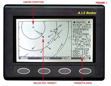
Yesterday Roger (a true DYI guy I’ve noted before) commented enthusiastically on Nasa Marine’s “AIS Radar.” It certainly does seem to provide a complete AIS listener for a very reasonable price, about $365, but I have some concerns. The main one is that Nasa “chose to simulate the plan position indicator (PPI) of a conventional radar display” (hence the name). In other words the target vessels are plotted relative to your own boat’s course and speed, not their true course and speed (though that’s shown in the data window). The goal is simplicity; a target on a collision course will generate a trail headed right at you. The problem is the plotting confusion possible when you change course or speed. Plus AIS Radar, like Nasa’s AIS Engine, only uses one frequency at a time—though that may not be an issue. And, finally, it does not support output to a PC. For more information, allGadgets has the manual posted here. Of course, my concerns may be unwarranted; I’d like to hear from users and/or try one myself.
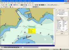
In addition to Kees’ report yesterday, Dan sent in a link describing another successful test of the Nasa AIS engine, this time in conjunction with GPSNavX charting software for Mac computers. (Thanks, Dan, and I’ll follow up on your other Mac navigation suggestions soon). PC Maritime's interesting Navmaster Superyacht AIS package (look in the Leisure section) includes the same Nasa engine, which passed the company’s own testing and is reportedly pleasing early users. Superyacht’s AIS display looks like the best I’ve seen to date. Click here for the full screen shot and notice how the vessel is drawn to correct scale and its predicted track, i.e. rate of turn, is shown along with its heading. The user gets to control what data gets shown with the AIS target, plus the sidebar neatly categorizes all possible AIS info. I still want to know if there's a downside to only receiving one AIS channel at a time (I've asked Nasa), but it sure is exciting to see AIS hardware, and software, rapidly becoming affordable for even medium size yachts.
Update: “The same data is sent alternately on both channels so listening on one channel only is not much of a limitation. (It means the unit would 'hear' data every 6 seconds rather than 3 seconds from a vessel travelling at speed.)” — Nasa Marine
I’d never heard of this Nasa AIS “Engine” before, but oddly got two e-mails yesterday that referenced it. It seems almost too good to be true: a simple AIS listener that can feed ship information to a PC’s serial port for a mere $200 (plus cost of VHF antenna). It’s sold by a U.K. firm here, but does not seem to be listed at its manufacturer’s site here. One spec I see that might be a deal breaker is that a user must “Select 161.975 or 162.025 MHZ operation”. I thought AIS devices automatically use both. Please, someone, educate me on these mysteries!
Update: Be sure to read the comment from reader Kees who owns one of these listeners, reports good performance, and terms it an �outstanding no unbelievable value...� Thanks, Kees!
Just got a note from a beloved, though former, in-law who’s wicked frustrated in his quest to find the right radar/plotter for his classic sail boat. The Raymarine C80 would do the trick, except for all the “damn cables”:
“There are at least three of them to allow for radar, gps, and power, and more if you want more instruments. And these are not lightweight lamp cords, either: the C-series specs tell us to allow 8" clearance behind the instrument for the radar cable. Absurd. And it really ties down the unit to a very fixed mount, which is my ultimate objection. I'd like to have it mounted at the nav station, but be able to swing it out to the cockpit at need. It's possible, but with all those heavy cables, very clumsy and inelegant.”
He wonders if there is a black box solution with wireless display? There is the Panasonic MDWD and other untethered PC solutions, not to mention some really interesting wireless instruments coming from the likes of TackTick and Deep Blue Marine, but a real marine portable multifunction display doesn’t really exist…yet. The good news is that most of the big boys—Furuno, Northstar, Garmin, and Raymarine—now use Ethernet to connect multiple displays, which means a WiFi connection is quite possible. (My “it could be worse” photo shows one locker on the bridge of a mega yacht under construction in Italy.)
Why do C-Map’s full page ads for its new Max chart format feature a woman wearing a cartographic body suit? Even the model looks like she thinks it a goofy idea! Especially since Max has so many interesting and graphic new features — panoramic photos of harbor entrances, animated tidal current predictions and navigation light characteristics, street mapping, 15 levels of land contours and 32 of depth (now in 256 colors), and a perspective view that let’s a navigator see chart detail up close to the boat while still keeping an eye on what’s further ahead. And none of it has been seen on plotters before. C-Map has a dedicated Max site here. I wrote about Max and Navionics’ new Platinum format (not much on the Web yet) for the June issues of PMY and Sail, and we tried to use as many illustrations as possible. I think that both new formats are sexy, but not literally!

 Nobeltec just announced an InSight Sounder option for its VNS and Admiral charting+++ programs. The company can now supply the soft– and hardware for plotting, radar, AIS, and fishfinding, including a heading sensor and even a wireless display. Nobeltec has also established a relationship with SkyMate, the easy-to-use satellite messaging and monitoring system that I’ve followed with much interest. Their respective programs can now share a PC and sensors nicely, and maybe more (not much on either company’s sites yet). Finally, Nobeltec has slashed the price of its AIS listener (was it the first to offer AIS to yachts?), and is running some new rebate programs. And we can imagine that the lads in the lab are working on more ways to expand the total package.
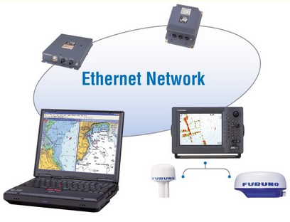

 In addition to Kees’ report
 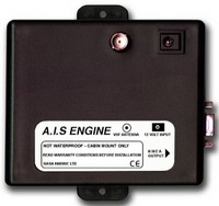 I’d never heard of this Nasa AIS “Engine” before, but oddly got two e-mails yesterday that referenced it. It seems almost too good to be true: a simple AIS listener that can feed ship information to a PC’s serial port for a mere $200 (plus cost of VHF antenna). It’s sold by a U.K. firm
 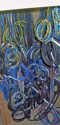 Just got a note from a beloved, though former, in-law who’s wicked frustrated in his quest to find the right radar/plotter for his classic sail boat. The