
NMEA 2000, on the water
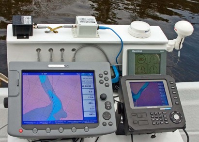
It was another damp weekend in Maine, but the leaves are popping and I finally got out on the water. The NMEA 2000 test rig performed fabulously. Check out the bigger image here to see how the Raymarine E120 and Simrad CX34 are both getting GPS, heading, speed through the water, etc. from the Maretron sensors. A PC charting program could have been easily sharing it too, had I dared bring a laptop along. At this moment I was drifting (speed 0, SOG 2.2; heading 85, COG 64) down the St. George River with…errrr…a rather high level of situational awareness. Both plotters were able to calculate current set and drift pretty accurately, and the Maretron display kept track of the little boat’s pitch, roll, and rate of turn. And I had even more redundancy than expected…it turns out that if I unplug the Maretron GPS, the E120 will switch over to the Simrad GPS that’s plugged into the CX34. The one glitch was the depth delivered by the Maretron transducer, much shallower than shown, but I’m sure there’s an explanation. Plus I had another sounder, not shown, and in fact the shoal area ahead is deeper than charted. And it’s a lovely river to gunkhole (click here for an experiment with Maptech’s chart server).
Nothing like doing a test on the St. George river. I wonder if the new charting programs will ever find a way to plot 6 trillion lobster pots littering the channel there.