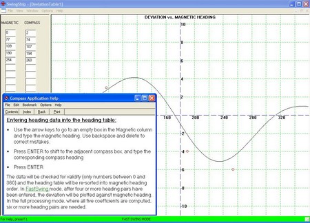
Nova Marine recently brought out a compass deviation and correction program called Swingship. Even the free download version could help you at least document just how out of whack, or accurate, your steering compass really is. If you care. It’s interesting how differently even very experienced boaters think on this subject. “The magnetic compass is the primary navigation instrument on any vessel,” writes the developer of Swingship, who I’ve heard is a solo trans ocean sailor. But the salty gent who took me out on his big Eastbay doesn’t much care that his beautifully mounted compass is off. Jeff Kauffman—a compass adjuster for 17 years, a serious delivery skipper even longer—told me this morning, “It’s a bitter pill for guys like me, but there is no question that the magnetic compass has become the secondary heading device on most boats.” I didn’t get to tag along with Jeff on that adjustment job last week, but today I got an interesting blow by blow description. I’ll write up the story soon. In the meantime, I’m deep into compass study. Sorry to report that while the online version of Bowditch (American Practical Navigator) still has a useful chapter on compass technology, gone is the detailed one on compass error that I see in my 1984 print edition. Also took another look at Alan Gurney’s Compass, a history I read last spring. What a fine book.
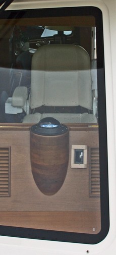
At right is a aft-looking view of the Eastbay helm I visited last week. You can see some serious wood work that puts the steering compass right where you’d want it. The problem is that this compass performs poorly; apparently its deviation error varies with the status of various electronics and is therefore not correctable. I hear this story all the time. And the second part of the story is like most: the owner doesn’t much care, as he’s content with the COG and heading readings he gets from his GPS and the electronic compass in his autopilot. In fact, of the 4 new J-100s launched in my harbor this summer (there’s a sailboat model on fire!), only one has a magnetic compass (but all have 12” multifunction displays!). That really surprised me as sailors tend to be the most compass obsessed of boaters. What’s going on? Is the traditional compass going the way of the paper chart? Is there one on your boat? Is it adjusted properly? Do you use it? I’d appreciate your thoughts.
It happened that a very experienced compass adjuster I know stopped by yesterday. He told me that the compass above is a poor quality Danforth, and that a similarly sized Ritchie SS-2000 would likely do a better job. I’m hoping to tag along with Jeff on an adjustment job, and learn more about how to make a magnetic compass work well around a modern helm full of electro-magnetic forces.
By the way, the odd little frame next to the compass above is a serial port so that routes and waypoints can be uploaded into the Northstar 6000i’s via NMEA 0183.
Sorry if there’ve been too many “what’s on board” entries recently, but these are the high days of summer here, they don’t last long, and I’m enjoying them! Yesterday I took a little spin on this spiffy Eastbay 54SX; the ‘research’ will go into my next Helm Shot column in Voyaging. I’m particularly pleased with this picture (bigger here); I had to do a lot of fiddling to make it look like reality! (By the way, those are the Camden Hills out there; I live in the westward lee of the middle one).
Yes, there are FOUR Northstar 6000i’s on this single helm boat, but the very experienced owner—this may be his 13th sizable boat, he’s lost count—has his reasons. The two 10” displays on the Himalaya (that’s what they call that little mountain of an electronics cabinet you see on these tall windowed boats) are the main navigation tools, usually run chart left, radar right. (North up and head up, respectively…the man has been doing this a long time, and says he’s sticking with the modes he knows). They’re networked together with Northstar’s N2 (Ethernet), sharing a 4’ 12kw (special order) radar scanner, a GPS, and a black box fishfinder. The two smaller overhead displays share their own N2 network, another GPS, and a 4kw dome scanner. Redundancy! The system is also designed so that guests, or a co-pilot, can use that 6” display at far left without getting in the skipper’s way. Meanwhile the right 8” is ready to serve as backup if the main system packs up. (It’s also set to use radar overlay, which the owner admits to ‘peeking’ at on occasion ;-). There’s more of interest on this boat, but for later…
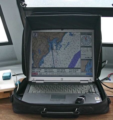
Over at rec.boats.electronics there’s a great thread underway about the ‘perfect’ built-in onboard computer. I’m particularly interested as I’ll likely go that route if and when I ever manage to finagle a larger cruising boat. In the meantime, last week I put some miles on the rather funky rig above (bigger here), and it actually performed pretty darn well, even gunkholing around the hairy unmarked ledges in Penobscot Bay’s outer waters (it was calm and clear). I used the old soft case (and sometimes a towel) to keep the laptop from sliding around. Valuable accessories are the Hoodman screen hood (really cuts glare, though I notice they don't seem to sell this model anymore), a tiny Atek optical USB mouse, and an old Deluo USB GPS (no WAAS and weak signals in my cabin, but still consistently accurate). Here I’m using Coastal Explorer 1.1 (now shipping), which is giving me that “the more I use it, the more I like it” feeling. It happens that the designer of CE has an interesting description of his own onboard PC system here.
My PMY column about testing NMEA 2000 is in print and online now, but something odd happened during the production process. It opens with a picture of the NMEA test setup aboard my little outboard boat, Gizmo. The screen on the laptop is naturally quite blown out in the open sunlight, so the PMY page designer asked the “color house” to goose it up a bit. Actually, this is often necessary to make photographs of LCD screens look more realistic, since a camera is nowhere near as agile as the human eye. But someone in the color house took a shortcut and simply copied the Raymarine E screen onto to the laptop, creating a very unrealistic image. Nobody noticed until it was printed.
At any rate, above is another image of the two NMEA 2000 plotters, plus a Standard Horizon CP1000, aboard my other test boat. It’s unretouched, meaning all the screens actually seemed brighter in reality, but it does show (bigger here) how comparatively bright the Raymarine E is (though note that the screens are not in direct sunlight, so transflective properties are not evident). If there was a laptop in the scene, it would look darn dim. (A March article I wrote about the E series is also now online, though without pictures.)
Test boat #2, by the way, is the long neglected Ralph, which deserves an entry one day. But today the missus and I are headed off for a long weekend of cruising aboard, so there will be no entry tomorrow unless I come across an odd WiFi connection in the outer islands.
How do they do that? The new JRC JLN-550 Speed Log at right is displaying not just 18k of forward speed over the ground (SOG), but is also showing that the bow is going to starboard at 1.8k and the stern to port at the same speed. The trick starts with a 4 beam 240 khz sonar transducer in the bow. The doppler shifting of the sonar pings off the bottom is used to get two axis SOG. The third axis (the stern motion) is calculated by adding rate-of-turn input from a gyro or ROT capable electronic compass. When bottom depths exceed 250 meters, the unit can switch to speed through the water (STW) using ultrasonics (2 mhz) to measure passing particles. Now this is big ship gear for sure—it starts at about $26,000, and the 265 pound transducer is termed “compact”—but accurate STW underway and multi axis SOG around docks would be very useful on medium size boats too. I’m hopeful. Airmar already has an ultrasonic speed transducer scaled for yachts (pdf brochure here). Now we just need a small, reasonably priced 4 beam sonar transducer.
I’m a long time fan of the PDA charting program Memory Map, which is also sold as Maptech Pocket Navigator, and think that its developer, Richard Stephens, is one hell of a programmer. It’s no great surprise then that Richard has mastered mini PC navigation, even while overnight racing aboard a wickedly wet Corsair 28R trimaran (In fact, it was so wet, at one point we had a 2’ long fish flapping around in the cockpit!). But it’s good to know that a coder is out there getting his butt soggy (getting to be one of my favorite blogs), and it surely is interesting to hear about his set up:
I used a PDA for navigation (of course). Itwas connected by Bluetooth to a GPS and to a cell phone in the cabin, which was in turn connected to a Digital Antenna signal booster and 4' antenna. The PDA was an iPaq 4700, in a Otterbox 1900 hard case. I wear the PDA most of the time, strapped to my body with bungee cord (under my PFD belt so it does not flap around). It is turned off when I am not actively navigating, to save power. I also wear a Garmin Foretrex on my wrist, programmed with the route and strategic waypoints [using Memory Map either on the PDA or a PC].
The PDA runs Memory-Map for navigation, using the full detail of NOAA raster charts, with all weekly NTM corrections applied. I used the cellular internet connection to access weather information from NOAA. The real-time buoy/weather station reports, weather radar images, and the ETA wind model. were all extremely useful at different stages of the race. All of these were accessed just using the web browser on the PDA.
Richard and the rest of the Flight Simulator team won first in class in their latest race, the Mackinac. How geek cool is that?
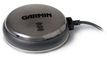
I tested a Garmin 276C last year, and it’s an excellent little chart plotter, and also quite adept at street navigation (screen selection, distance and speed units, and routing style all switch over with a single button push). The screen is very bright and very fast. In fact, it was one of my five “editor’s picks” for 2004 in Sail magazine. Now the 376C adds XM weather and audio, making this unit far and away the most unique portable on the market. You can even plug in a blackbox fishfinder. I also tried an early version of Garmin’s Network system, which included XM weather and radio. The interface to all this info was a little clunky, but I understand that it’s been vastly improved. Which I imagine we’ll see in the 376C. And the network's fairly large receiver and separate antenna have been reduced to the petite GXM 30 smart antenna shown above. The 376C retails for a grand, but you really could carry it, along with your subscriptions to XM weather and radio, from boat to car to home. Neato! (But do note that it does not include all U.S. charts, like the new 192C). Here's a higher res version of the image at top, showing some of XM weather’s rich data. Note the storm cell predictions and lightning tracking (which is 5 minutes fresh and extends 300 miles off the U.S. coast). And here’s a column I wrote about the Garmin phenomenon last year.
There’s finally some good Web material up about Navionics Platinum charts. Not surprisingly it’s at Raymarine’s site, as the E Series will be the first to display it. Definitely check out the “Feature Tour”, whose Flash animation illustrates some of Platinum’s dynamic nature. Raymarine calls this all a “Preview”, with the actual chart cards and E Series software upgrade “Coming Soon”. My sense is that it will be quite soon, as I’m starting to see ads too. Plus I’ve been trying out beta versions for a while now, and the software seems darn solid to me. Raymarine understandably asked me not to comment on beta product, but hopefully that too will change soon. In the meantime, one word: outstanding!
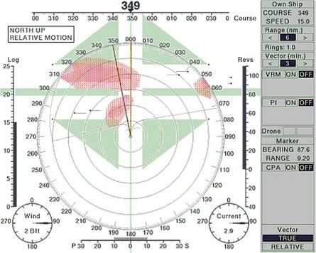
Fred Pot showed me a really interesting new concept in target plotting that was developed at a Dutch maritime school. Currently many plotters/PCs and radars can automatically use ARPA and/or AIS info to calculate the CPA (Closest Point of Approach) and TCPA (Time of CPA) for vessels within range. Typically they flash a warning if a potential CPA drops below a preset threshold like 1 mile, meaning that you and the other vessel are going to pass that close if you both maintain current course and speed. This is all good—and beats the hell out of manual plotting—but still leaves the operator to figure out how to change course/speed to avoid tight CPAs, which can get especially complicated when there are multiple vessels involved. “Safe Pass” works a little like computerized weather routing, calculating various CPA/TCPA data versus possible changes in your course and then plotting potential safe, and dangerous, areas ahead. In the example above, bigger here, you are about to cross a shipping lane with two vessels crossing each way. Turning left will make things worse, but turning right between the red “danger clouds” will result in a safe passage (assuming the other vessels maintain course and speed). The concept seems to make a lot of sense, and has purportedly tested well in ship simulators (at that Dutch school), but so far no developer is yet working to make it available. I wonder why not?

 At right is a aft-looking view of the Eastbay
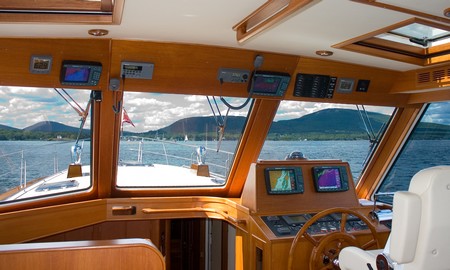
 My PMY column about testing NMEA 2000 is in print and
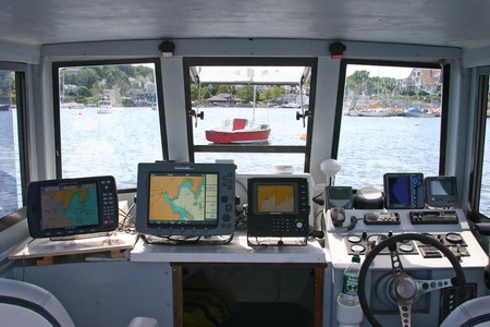
 How do they do that? The new JRC
  I’m a long time fan of the PDA charting program
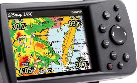
 You can even plug in a blackbox fishfinder. I also
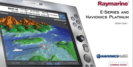