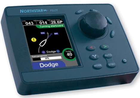
The wise judges of the DAME Design Awards have spoken, and the winner of the marine electronics category is Navman’s G-Pilot 3380. “This is an extremely cohesive product, with an attractive case design, intuitive controls and clear graphic displays on a 3.8in LCD colour screen that include animations, help prompts and a user-friendly compass page.” I’ve raved about this interface before and am pleased to note that it is now also available on the new Northstar 3300 autopilot, with a casing “system matched” to Northstar’s 6000i displays. The two sister companies are a little shy about this duplication, because otherwise their products are quite distinct, but, heck, why not? (Note that I have not tryed the Navman/Northstar pilot on the water, and doubt the judges did either. And even if we had, pilots can perform fine on one boat but not another. All of which is why it’s so hard to introduce a new autopilot.)
The winner of the Marine related software category is Navionics Platinum, which makes sense to me, and relevant Special Mentions include Airmar’s WeatherStation, Simrad’s SART, and something called Octoplex from Moritz Aerospace. I haven’t mentioned the latter yet, but got a good introduction at Lauderdale and agree with the Dame guys about its specialness. More to come.
The Garmin media team was busy last night, distributing a stack of complicated press releases and a pile o’ product shots, all to describe some 20 new units that were introduced at METS today (and will go on sale next March). Here are the bullet points I’ve gathered so far:
* New BlueChart G2 (next generation) charts feature 3D perspective, tides and currents overlay, and other enhancements, and a slew of new plotters, plotter/fishfinders, and network multifunction displays (like the 3206 above, bigger here) come preloaded with all U.S. coastal G2’s. (NOAA’s freebie policy strikes again!)
* But G2 is a two tier product, sort of like what Navionics is up to, and G2 chart cards add more data like detailed coastal roads, more POIs, and color aerial photos of critical areas. Garmin says that U.S. cards will start at $199, “far less than competitors”. (But I don’t know what that means exactly). G2, by the way, is not compatible with older plotters, except the 3000 series, but older BlueCharts will work in new plotters.
* Garmin has a new network called CANet, which can connect the smaller 292, 392, and 492 plotters with two new black box fishfinders or the new 398 full fishfinder. It sounds like a CANbus variant but is 1 megabit (?). The GSD-22 bb is Garmin’s “first digital sonar, allowing for more precise target separation and depth performance” and also supports Garmin’s MarineNet (Ethernet).
It’s going to be interesting to see how all these products stack up. I’m wondering, for instance, what Garmin’s version of 3D perspective looks like, and whether G2 will also come on CD. And, of course, pesky observers like Panbo reader R.O. are asking “what about NMEA 2000”. More to come, to be sure.
PS It will also be interesting to see who picked up DAME awards at METS today; this is one of the better innovation competitions out there, I think. And, by the way, Jeff Hummel is at METS and says he’ll write a Panbo guest blog on his findings.
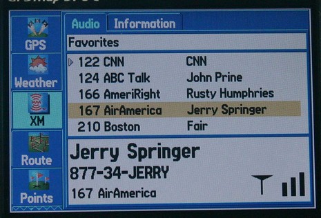
I would have posted earlier today, except that fooling with this Garmin 376C vividly reminded me (above, and bigger here) that the spell of dry, sunny weather was about to end. So I spent some hours winterizing the fleet, all the while watching the clouds thicken up from below and above. I could also see an animation of all that rain moving across New York state, plus the lightning strikes, the frontal lines, pressure gradients, wind predictions, buoy reports, etc. etc. It is phenomenal how well you can see all this info on the 376’s little screen. The display itself is exceptionally bright and detailed, and Garmin has also done a good job at letting you view the weather data mixed together or one element at a time. And, get this, I was also listening to XM radio (below). I’ve been trying the 376C intermittently over the last month or so, and am very, very impressed. It really makes sense in terms of carrying your XM weather and audio subscriptions with you on land or sea. The only con I can think of is that BlueCharts have gotten pretty expensive relative to the competition, but maybe that will change.
The Garmin 276C was one of my 5 Sail magazine “editor’s picks” for innovative, important marine electronics introduced last year. I’m working on my 2005 picks right now, and the 376C is definitely a contender. If you have suggestions for other hardware or software that should be on the list, please let me know.
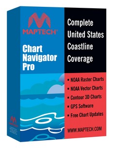
Whoa, things are happening even faster than enthusiastic yours truly thought possible. For $500, Maptech’s new Chart Navigator Pro (CNP) give’s you 13 (13!) DVDs containing NOAA’s entire portfolio of U.S. RNCs and ENCs, plus all of Maptech’s accessory cartography—photo maps, harbor panoramas, topos, bathy maps, pilot books, and information databases. But the real surprise inside is that Maptech ditched its aging, non-quilting, non-vector charting software in favor of Coastal Explorer. The name has changed, but CNP is CE 1.1 with nothing taken out and Maptech’s decent 3D contour engine added. CNP gets introduced today at the Fort Lauderdal Boat Show and will supposedly be in stores next month.
PS, 11/7: Thanks to Greg’s comment for a head’s up that Maptech has launched a new site, freeboatingcharts.com, where you can download all the U.S. RNCs you want. I don’t quite understand why Maptech is doing this before NOAA has a system in place, but it works fine. First you select the charts you want, then the site packages them up in a self executing zip file and notifies you when it’s ready for download. It only took maybe a half hour for me to receive the 15 charts that cover my area in all scales.
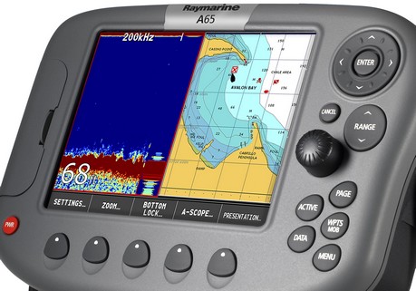
Next week in Ft. Lauderdale I’ll get an on-the-water demo of the new Raymarine A65 along with its included Navionics Silver chart card…so details then, apparent strategies now:
* The A65 is a 6.5”, though full VGA, plotter/fishfinder (or plain plotter) that seems to incorporate Raymarine’s crisp digital sonar technology and some of the friendly soft key interface seen in the C and E Series. It does not support radar, a high speed bus, or even SeaTalk2/NMEA 2000, but it does seem to offer some bigger boat electronics goodness in a smaller package (and price, though I don’t have the exact numbers just yet).
* The A65 comes with a Navionics Silver CF card that includes full detail coverage of the entire US coast. My understanding is that this signals the beginning of Navionics’ three tier chart strategy—Silver, Gold, Platinum…good, better, best. All the details aren’t out but the idea is that users of at least some machines can upgrade through the tiers as desired; meanwhile Navionics can move features down through the tiers as competition dictates. Slick.
The total package seems like a big “hello” to Garmin’s 192/198 series, Lowrance’s NauticPath etc., and also, in a way, to NOAA’s imminent giving away of all U.S. raster charts. (And a note to readers from outside the States: sorry that your governments are not pushing vendors to provide more and better chart coverage for less money, but then again you don’t have a powerful politician trying to gag your met offices.)
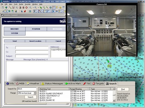
Last night Nobeltec announced the new features coming to VNS and Admiral 8.0 PC navigation software; they’ve been busy! Both packages integrate camera/video displays (for DirectX enabled cameras) and SkyMate communications, plus add a place-name search capability (all illustrated in my collage above, bigger here). Both also now support NOAA ENCs and will plot DSC VHF calls. AIS target tracking has expanded from Admiral to VNS and Nobeltec will be selling the single frequency NASA/Si-Tex AIS100 receiver [corrected 10/16]. Meanwhile, Admiral will now be able to support multiple radars and the InSight Sounder over a GlassBridge Network, resulting in such sexy system possibilities as the one diagrammed below.
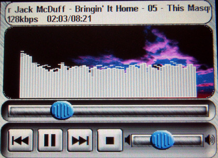
The music screen above is from a Lowrance iWay automobile mapping system. It has a touchscreen and a 20 gig hard drive—partitioned so that 10 gigs are for onboard maps, 10 for tunes. PC Magazine made the iWay its Editor’s Choice in a May roundup review that included units from Garmin, Magellan, and Navman. I just came across it and was reminded of how Darrell Lowrance enthused about touch screens for multifunction marine displays during a press conference at the Miami Boat Show last winter. Lowrance’s best 2005 plotter/fishfinders are already similar to the iWay series in many aspects, like the hard drive; will they get touchscreens and MP3 players next year? There’s a ferocious competition going on to be a dominant player in the car plotter market, which has got to explode at some point. What are the manufacturers learning and developing that might migrate to boats?
I hesitate to report RUMORS, but given that strong caveat, these seem worth a “head’s up”: supposedly Lowrance’s NMEA 2000 GPS sensors have trouble with radar transmissions, and supposedly its NauticPath marine charts don’t properly show obstructions that are awash between high and low tide. Mind you, these are only rumors and, even if true, may have been fixed already or are about to be.
I learned about SeaRef the hard way, when its developer Dan Podell tried to advertise it by posting messages on the PMY forums. That’s a no-no there, and here too, but I did contact Dan to tell him that I’d be happy to have a look at his CD full of nautical info. I’m doing that right now, and am impressed. SeaRef is a well organized compendium of useful calculators, tables, and publications. The example above is a page from a hyperlinked .pdf version of the BC Sailing Directions. You can learn more about the CD’s contents, or buy it, at Podell’s eBay site.
You may realize that most, maybe all, of SeaRef’s contents can be downloaded for free from various web sites, but I’d say that Podell is charging a very reasonable fee for finding it all and organizing it with .html pages. You may also realize that the SetSail.com Navigator’s Library is a similar product. I tried an earlier edition of that product and note that it now comes on 2 CD’s and contains a number of items missing from SeaRef, like the complete Bowditch, the CIA World Factbook, and numerous Sailing Directions for areas outside North America. On the other hand, it’s more expensive and at least the edition I tried had a fairly obnoxious copy protection scheme. SeaRef is unprotected and has items NL doesn’t, like a Medical Handbook (oriented to ships, like much of this material, though still useful), flags of the world, and much more.
PS If you have a marine electronics/navigation product you want me to know about or try, please just e-mail me ([email protected]).
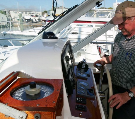
The compass adjustment trip that I missed the other day was aboard a nearly brand new, high quality 30’ power boat. But the steering compass, a decent Ritchie SS1000, turned out to be 45° off on some headings and “limp” if you were pointed north! Jeff Kaufmann tells me that this is just an extreme example of a common situation. Boatbuilders may install the compass but don’t pay attention to the deviation, leaving that for whoever installs all the electronics, who may not pay attention either. Jeff says his fee is sometimes paid by a yacht broker trying to complete a deal, because no one else will take responsibility.
At any rate, Jeff took this boat out into Penobscot Bay and used a GPS bearing to a fixed and charted object to get one solid bearing. With that reference he could then use his directional gyro (lower left in the Bloomquist photo above, home built from old military parts) to check the compass on multiple headings. Then he used that little magnetometer in his hand to look for the culprits. The main problem turned out to be a large steel hydraulic steering control mounted almost directly under the compass (the yacht in the picture is not the same boat, by the way).
Using well developed intuition plus trial and error, he figured out where to position an external magnet to negate the offending one. That took a big bite out the worst deviations, plus made the compass lively again on North headings. Then he used the SS1000’s small built-in correction magnets to get the deviation nearly to zero on all headings. Finally, he checked for possible transient problems and found one in the windshield wiper motor, which he couldn’t fix, of course, but did note on the deviation card. Jeff has come across a lot of odd compass problems over the years; I think at this point he can look around a boat and visualize 3D magnetic fields emanating from wiper motors, power cables, buzzers, hunks of steel, CRT tubes, etc. etc.
Ritchie, incidentally, has a good guide to compass basics that they will send you for free or let you download as a .pdf.
I’m back from Boston, where Navionics showed a bunch of boating writers what Platinum cartography looks like on the water, and also laid out its overall product plan for 2006. Panbo-wise, it’s all a little frustrating. I’ve been beta testing Platinum on a Raymarine E-120 all summer, and have tons of photos and screen shots to illustrate its features in detail. However, I agreed to Raymarine’s understandable request that I not use anything until the code is finalized. Soon, I’m told, very soon. (I got the shot above, and bigger here, during the demo; on the left screen you can see how big the oblique marina and port entrance photos are. Incidentally, when there was a chart on that screen, it was neat to see how well it could synchronize with the 3D screen at right, something I hadn’t seen in my testing).
Similarly, I can’t yet talk about what Navionics is up to in 2006 (very interesting). Instant Panbo publishing is a little too fast for these guys! I may run into this situation a lot this fall, as electronics companies reveal their new products, often timed to magazine cycles two or more months long. Plus my Panbo posting schedule is going to be choppy. In the next six weeks I’ve got a ‘research’ cruise with my daughter on the Hudson river, a press junket to the French Riviera, two trips to Florida (NMEA conference and Ft. Lauderdale boat show), and a completely non nautical but spectacular conference (Pop!Tech) where I volunteer so I can hear what some really large brains are thinking about our tech future. I think of this fall period as a regime of fattening my own brain for the winter ahead.


 called CANet, which can connect the smaller 292, 392, and 492 plotters with two new black box fishfinders or the new 398 full fishfinder. It sounds like a CANbus variant but is 1 megabit (?). The GSD-22 bb is Garmin’s “first digital sonar, allowing for more precise target separation and depth performance” and also supports Garmin’s MarineNet (Ethernet).
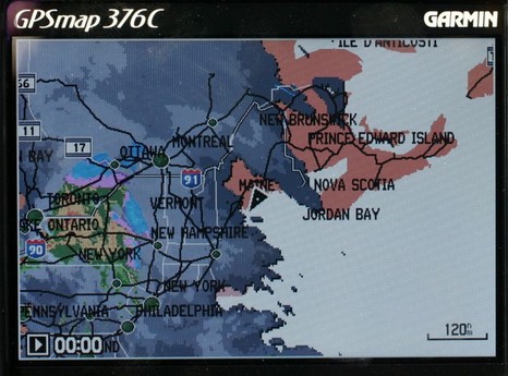
 Whoa, things are happening even faster than enthusiastic yours truly