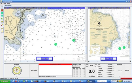
I’ll characterize NavGator Mariner, above, as a work in process. I couldn’t find many normal ECS features, only rasters are supported, and the chart management is crude to say the least. What’s interesting, though, is that NavGator is written in Java so that it can run on multiple operating systems. So far that means Windows, Linux, and Sun Solaris, but others will “soon be released”. The developer also has a Pro version “designed to be the core of the ‘glass cockpit’, where all electronic functions are integrated into a seamless, highly reliable, high performance environment.” The full screen shot is here (also showing off the full 1440 x 900 pixel goodness of my new laptop LCD).
The May issue of BoatUS magazine has this “Action Alert”:
With no warning to users, the U.S. Coast Guard has proposed termination of the Loran system by requesting zero budget for Loran in its FY 07 budget request sent to Congress. This surprising development came with no stakeholders’ input and after the Coast Guard spent $160 million modernizing the Loran system, an improvement in signal strength, maintenance and coverage that is nearly complete.
Surprise, indeed! For years I’ve been telling folks that an improved Loran will return as a back-up to GPS. What gives? Well, I take solace in the rosy report currently on the opening page of the International Loran Association, well worth a read even if it predates the USCG announcement. According to the author—the inimitable and very credible Langhorne Bond, who I once interviewed for an article about GPS vunerability—Loran has proven itself the perfect complement to the satellite system for marine and aero navigation, not to mention precision timing (for power plants and much more). But he does note that fair allocation of the operating costs is an issue:
The Coast Guard pays the full operating costs and feels this is inequitable due to the future multi-model uses of LORAN.The Coast Guard is dead right, although the inter-agency discussion of this is likely to be gritty.
Gritty? Ah ha! I’m hoping that the CG budget surprise is not really about killing Loran, but about forcing other agencies to help pay for it. Still, we should all play our part. I’m taking BoatUS’s advice to write my congress people, only I’m adding a line about sharing the costs/giving the CG a break. I also plan to test the loaner eLoran I’ve been neglecting.
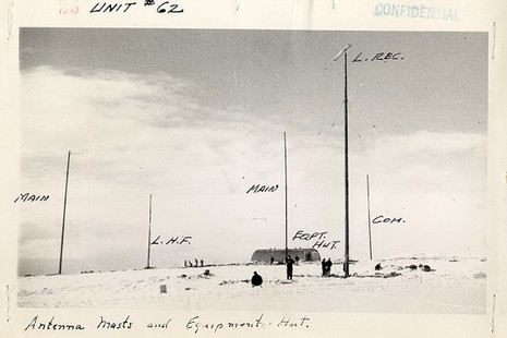
By the way, the picture, flushed out by Google images, is a Loran station on Attu in 1945. There’s even a bit of its history online. The USCG has been at this for some time.
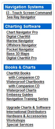
Yesterday we learned for sure that Maptech has acquired a bunch more marine navigation products, which must somehow be integrated with all the products it already sells. Heck, the long list at right doesn’t even include its latest offering. Here’s a peek at how it’s going to work as explained to me by Maptech PR manager Martin Fox and others:
* The Capn charting software—apparently the main impetus for this deal—will become Maptech’s commercial level product, with customization and fleet pricing available. Recreational users may be offered an easy switch to Chart Navigator Pro, and certainly won’t be left adrift. Dennis Mills, always the chief developer of The Capn, stays on as Product Manager (and is tickled about it).
* The SoftChart brand, on the other hand, will not survive, but some of its technology will. The plan is not finalized but Maptech may adopt some SoftChart features like its highly saturated raster chart color pallet (very effective on dim monitors) as well as a much less obvious “vertices” technique that improves chart quilting. Supposedly there’s also some interesting vector chart assets changing hands. Like Mills, Dick Davis—director of SoftChart cartography since 1995, and head of NOAA’s raster development team before that—is pleased about where his work has ended up, though he will not be working for Maptech.
* Maptech is “not sure” yet what it’s going to do with MarinePlanner.com, but I recall that the site has some interesting weather forecasting, trip planning, and other goodies (though they�re almost all locked behind a �membership� scheme right now).
* Finally, Captain Jack’s online and print catalogs will come back to life, but as an operation “totally separate” from Maptech. Fox must have used that “separate” word a dozen times, which got me laughing and is an indication that Maptech is a little nervous about annoying its own dealers. At any rate, the new Captain Jack’s “won’t look anything like a Maptech catalog” and its emphasis will be on “solutions”, i.e. bundles of products like, say, a GPS loaded with waypoints from an included ChartKit Book. I dare say it will also still include a nice collection of PC charting accessories, and that’s good.
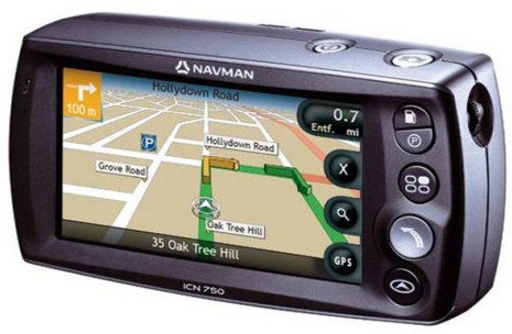
I don’t normally get into car navigation but this is an interesting idea, and it’s from a company that’s very much in Panbo’s radar. The Navman ICN750 above has a built-in camera meant not for snapshots but for easily shooting geopositioned photographs—dubbed NavPix—that you can later page through and select as go-to waypoints. Associated PC software and a NavPix Web site will even let you share such image waypoints with family, or the world. The press release quotes Navman USA general manager Chris Jensen thusly, “We tend to remember images better than we remember addresses. We all know what the Washington Monument looks like, but do we know the actual address? Most of us have commented to a driver at least once in our lives, ‘I’ll know it when I see it!’ Navman, NavPix technology and the global NavPix community set the new standard for navigation simplicity.”
Would this idea apply to marine plotters, where the ‘addresses’ are even harder to remember latitude/longitude numbers? Hell yes. In fact, I think boaters will eventually get all sorts of benefits from the fierce competition for the potentially humongous automobile navigation market. However, that same fierce competition is why it makes some sense for Brunswick to sell off the land navigation portion of Navman; it is not, as they say, a ‘core’ business. But why is Brunswick also selling off Navman’s marine division, already separated into Brunswick New Technologies Marine Electronics (BNTME) along with Northstar and MX Marine? I have heard a lot of rumors and speculation in the last week, but no one really seems to know. Tomorrow I get to chat with David Ritblatt, president of BNTME, and that should be interesting!
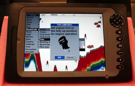
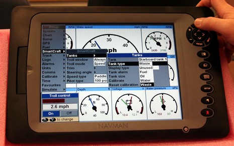
I don’t know why I haven’t mentioned the Navman 8120 before, because I surely was impressed when I had a chance to fool with it last December. But now it’s particularly noteworthy as the company supposedly has a “For Sale” sign on the door (s). Navman has good online dope on this single station multifunction display that was reportedly dubbed the “C120 Killer” during development, and for now I’ll just note that it really does challenge Raymarine on features and value. What I want to point out today is how very neatly it interfaces with SmartCraft, i.e. Mercury and Cummins engines built by Brunswick. Check out bigger versions of the screen above, and below. Navman told me they don’t like comparing that “Troll control” to cruise control, but have you ever seen anything like that on a plotter/fishfinder/radar? Cool stuff.
Now some questions. If you were buying electronics next week, or advising someone about it (as I know many of you do), would you go for a company that is in transition, even if its product looks terrific? That’s why Brunswick’s announcement seems strange, even dumb. But, what if we learn next week or next month that Navman and Northstar will soon belong to a large and respectable marine electronics company that has never offered navigation gear before? That might seem smart indeed. Have a great weekend.
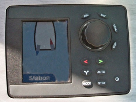
So what do I mean that the new Zeus propulsion system has nerves as well as brains? Well, hooked into the drive controller is an ultra high precision GPS and inertial navigation sensor which feeds it fast updates on the boat’s location along with which way she’s heading, sliding, twisting, rolling etc. Thus the drive gets instant feedback about how well it’s doing what you asked it to do. In other words, if you’re coming alongside a dock and you push the joystick a little bit to starboard, Zeus will take you a little bit to starboard no matter if the current or wind are pushing you hard toward the dock, away from it, or in some other direction. Zeus can do what the very best boat driver does, i.e. observe what the yacht is actually doing in real time, figure out all the forces involved, and compensate for them to get her to go where he wants her to go. Of course the ultimate expression of a totally integrated drive/navigation system like this is its ability to hold station, which seemed rock solid during the demo. It works so well, in fact, that the Cummins guys say they have put Ingenuity next to dock and stepped ashore—no dock lines (though that will never be an advertised feature). That well!
Now it must be noted that the specific navigation sensor hardware being used on the demo is apparently a very expensive Oxford Technologies RT3000 working with private Omnistar differential GPS corrections, which adds a serious subscription expense. But it’s clear that Brunswick’s electronics division is hard at work trying to provide the needed level of precision by the time Zeus becomes a real shipping system. In fact, Zeus may explain why Brunswick picked up MX Marine, which I couldn’t figure out last Spring. The image above shows a Navman/Northstar auto pilot that’s been souped up to work with Zeus’s amazing capabilities (note how the pilot is neatly showing you what the drives are up to as you cast a line, or take a picture, or whatever). It seems obvious that many Zeus boats will be Brunswick hulls with Brunswick drives and Brunswick electronics—all one—which is worth one more Zeus entry, tomorrow.
Maptech’s freeboatingcharts.com is now offering a DVD with all current NOAA raster charts, all Corp of Engineers river charts, and a real charting program for $50. The charts are organised on the disc into 23 ChartKit-style regions, and this deal even includes technical support. The software is Offshore Navigator Lite, the same program that now comes free with Maptech’s printed ChartKits and Waterproof Chartbooks. It’s not great, but it’s not bad either. I’ll try to write more about it soon, as well as the Zeus thing I started! Have a great weekend.
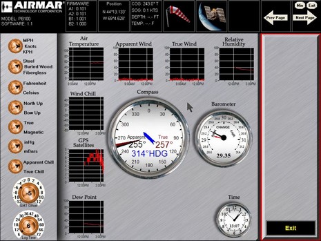
I’ve been posting on Panbo for almost exactly a year now, and one of my first entries was about the sailing version of Airmar’s WeatherStation. While I’m sorry to report that that product still does not exist, the powerboat version does and I’ve been testing one. Above, and bigger here, is a screenshot of the PC software that comes with the ultrasonic (no moving parts!) sensor. This particular screen shows the controls available (left) and also what data can be graphed over time. Clicking on any of those graphs switches it to the gauge-style real-time reading. The software is very easy to use but needs some work; for instance, the wind speeds are graphed to a 0–100 knot scale, which means that low speeds hardly show any differentiation. And wind direction history is not kept, which is something that must be fixed for the coming sailboat version (which won’t have a GPS, but will have an inclinometer supposedly able to correct the wind sensor for heel).
But I quibble. There are a lot of neat ways to use the WeatherStation, well illustrated in its latest PDF brochure. I have most of the setup below working (I just haven’t installed the “Smart” depth/speed/temp sensor yet), and it’s a powerful little network. A PC charting program like CE easily collects wind/GPS/heading/air temp coming out of the optional combiner via USB at 57,600 baud, plus the Furuno RD30 (a very handy device) provides alternate data display, and there’s room to run more NMEA 0183 devices into or out of the combiner. Nice detail: according to the WeatherStation manual (another PDF) the combiner favors alternate GPS or heading inputs over what’s built into the unit. I think that means that the built-in sensors can serve as automatic back ups. Nice!
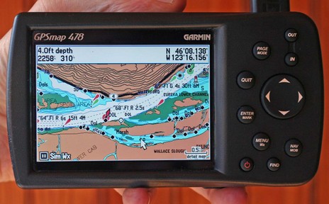
I suppose it was predictable, but it’s still amazing. The Garmin 478 above has all the XM Weather and Audio abilities that distinquished the 376C, and it comes loaded with all U.S. charts and all U.S. and Canada road maps. It’s fast too, even the ‘Find’ command is not slowed up by what must be a zillion POIs, nav aids, intersections, etc. stored somewhere in that little casing (and hence I’d bet that Garmin has sped up Find in the first all-U.S.-charts 192C I tested last summer).
Not that the 478 is perfect, even if there is nothing like it out there. For instance, these are the new G2 charts, but apparently the 478 will not be able to show the vaunted perspective view. I do gather from the spec page that it will show the photos available on G2 cards, and the screen above (bigger here) does look richer than regular BlueCharts. But, as good as this screen is, I find myself wanting to plug the 478 into a bigger monitor, maybe use a wireless keyboard and mouse with it too. The unit lets you use an expensive XM subscription anywhere you go but in some of those places, like a boat, you may want to expand the system. Just a thought, probably inspired by how rapidly this unit has evolved over the years.
I should also add that the Panbo reader who recently complained about the “Surface Wind” coming from XM to this machine was right; it’s old. He tells me that Garmin has acknowledged the problem and is working on it, but I also noticed this time around that you don’t get predicted wind and wave model data, something the new Sirius Marine Weather is very good at.
Garmin also announced a new pair of radar scanners this week, this time inside a smaller, 24” diameter casing, and with more emphasis on the digital processing going on in there. Finally, though Garmin hasn’t yet promoted it, many of its new plotters apparently do support AIS. The 478 is not one of them but I think I’ll soon get the chance to try it on a 3210.
Are you old enough to remember Superman on TV? “It’s a bird! It’s a plane! It’s Superman!!!” That’s what came up in my fuddled brain when first presented with Standard’s first-of-its-kind what-the-heck-is-that? VHF and chart plotter combo machine. If you look close, the screen above is an obvious dummy, but I saw the unit running in Miami and was impressed. That screen is a 7” wide style—hi res (800 x 480 pixels) and hi bright. The CVP fully supports C-Map Max and its interface looked quite polished up compared to the old CP series (which wasn’t bad). The radio is full Class D DSC with a 30 watt hailer/horn built in, and you can add two RAM+ or telephone style mics if desired. You can also hang a black box fishfinder on this ($1,100 MAP priced) thing, making it quite the all-in-one for, say, a center console fishing machine or a tuna tower, or a sailboat helm. The designed-in ‘handle’ on the right side might be useful in those places too. Of course all the DSC benefits of interfacing GPS/plotter and VHF come built-in, just add an MMSI to get position with distress call, plot your buddies, etc. By the way, that area of marine communications is about to get a boost as Sea Tow rolls out an interesting new marine operator service called Sea Smart. More on that in few weeks.

 Yesterday