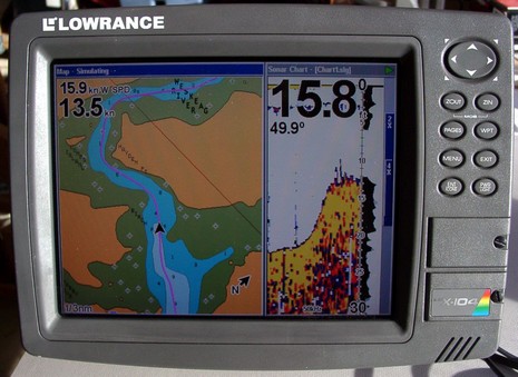
Here’s an interesting question: “I am looking for a combo GPS/Sounder for my dinghy, which will record depth data along the GPS track (so we can go out, find the channel, and then bring the dinghy GPS/Sounder to the mother ship and follow the track/depth data).” I can’t think of any truly portable solutions that would work in a rowboat, but I happen to know that this man’s ‘dinghy’ is actually a center console skiff. And that means that any of Lowrance’s recording GPS/fishfinder units, like say a 5” LMS-332C, might do the job. For years now, Lowrance combo units have been able to record your GPS track and sonar imagery to an MMC/SD card (and now to the 20gig hard drives in some units). You can play chart and sonar back on the display itself, split screen like below, or you can put the card in a reader and watch just the sonar scroll on your PC using free viewing software. The picture below (and bigger here) is me trying this feature a few years ago in some skinny Maine waters, and it worked quite well (note: that’s a Navionics Gold chart, not a Lowrance NauticPath). And, by the way, you can also play the recordings back in the nifty PC Product Emulators that Lowrance also gives away. But all this might be overkill in terms of collecting soundings in a poorly charted anchorage. Does anyone know a neat way to collect a depth/position data stream from a small boat, then display it nicely on an electronic chart?
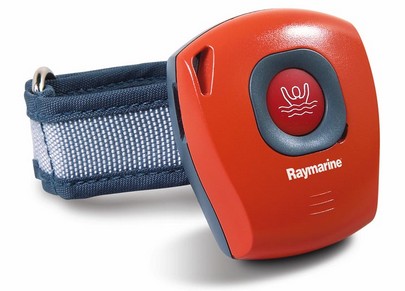
Raymarine needs a copy editor (Panbo does too!), but otherwise this sneak peek page has a lot going for it. Sirius Satellite Weather is happening on the E Series; C & E get AIS plotting, plus better data and NMEA 2000 engine displays; and the technology under the new 18” and 23” radomes sounds very interesting indeed. Raymarine is also introducing an active RF LifeTag man overboard system. Up to 16 crew members wear the gizmo above and a system-wide SeaTalk alarm will go off if a wearer gets too far from the receiver, or if he/she pushes that button.
PS. I often use Google to check spelling and/or word usage, and am dumbfounded to find millions of “sneak peak” in use, including ABC and PBS. Wouldn’t that “sneak peak” be “the top of a hill or mountain ending in a point” that’s also “carried out in a clandestine manner”? Am I missing something here?
My head hurts! I’ve got 11 ECS packages installed here now, and I’ve been fooling with them on two computers for the last several days. Would you be surprised to hear that Windows XP has occasionally crashed, sometimes violently, and not everything plays together nicely? Like when I start Nobeltec Admiral 8.1, MaxSea 12.2 also tries to start! I have the two computers connected with a null serial cable, meaning I can run NemaTalker (a great utility from SailSoft) on either one and an ECS running on the other thinks it hears, say, the virtual GPS above, which I control, plus a sounder, compass, etc.. In other words, I can ‘drive’ the boat on one screen, and plot the results on another. It’s geek fun for sure and a better way to test an ECS than with its built-in simulator/DR function. Unfortunately NemaTalker (full screen here) does not send AIS targets, and there aren’t many where I live, but one ECS provides its own test AIS in a very interesting way, explained tomorrow.
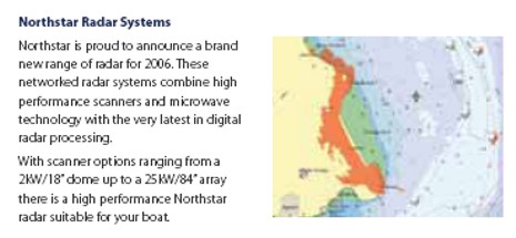
The Northstar 8000i will get a lot of attention in Miami. In fact, I just scratched the surface when I profiled its touch screen technology and overall architecture in early January. For instance, I didn’t mention the radar scanners, which are entirely new. The hardware is from JRC, the software from Northstar [correction: Northstar also designed the processor hardware], and I’m told that the results are amazing. At any rate, a British company has just put up the Northstar 2006 catalog, which has the best material I’ve seen yet on the 8000i. It’s a 3 meg .pdf file here.
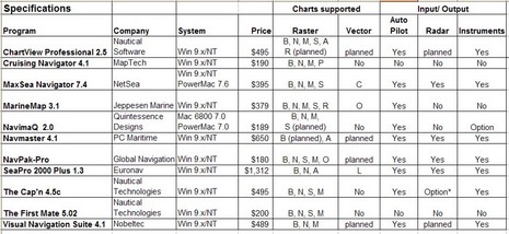
I was so wet behind the ears! One my first attempts at magazine writing was an overview of Electronic Charting Systems (ECS) for the Sept/Oct 1999 issue of Ocean Navigator. I spent months doing the research, actually installing and testing all eleven programs above (table bigger here), and wrote some 11,000 words on the subject. I recall that ON was surprised at the size of it, but published almost the whole thing (some is still online, titled "Power navigation", though you’ll need a subscription to read it).
At any rate—though I’ve tried to avoid big overview articles, particularly about ECS, ever since—I’m about to write one for Sail (which I’ll probably modify at some point for PMY). I’ve got to fit it in 2,000 words/six pages, and my idea is to highlight a good selection of particularly well done features, hopefully in as many different programs as possible. It goes with the idea that there is no perfect program for everyone, and that you can learn a lot about what’s possible via diligent shopping. I’d love your help. What do you think Nobeltec VNS, or Coastal Navigator, or RayTech or whatever does particularly well? And what ECS features are important to you, anyway? Please post ideas in the comments or just e-mail me. Developer comments welcome too.
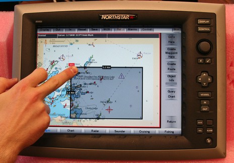
Touch screen does seem like “the natural interface” (as I just read at some promotional site), but there are two gripes about using it on the water: one, the technology can reduce precious screen brightness 10–20%, and, two, it’s hard to use when a boat starts bouncing around. Northstar has addressed both issues:
* The 8000i uses an unusual infrared touch screen technology; LEDs and photo cells hidden in the bezel create a invisible light grid which your fingertip interrupts. It seemed to work quite nicely during my demo and it doesn’t reduce screen brightness at all. Supposedly even gloved fingers and sticky fish scales won’t phase it. By the way, in the picture above (bigger here), the 8000i is zooming out by tapping a desired new center spot (red target) and dragging a box from lower right to upper left to define the zoom level. Left to right zooms in, the shaded borders let you pan, and all those touch keys can be hidden with the upper right ‘min’ button.
* But there are also zoom ‘in’ and ‘out’ buttons built right into the 12” 8000i, or you can plug in the dedicated key board seen in the system diagram with the 15” model, or you can use any other USB keyboard or pointing device. Interface flexibility!
This 12” unit, incidently, contains a 1.2 GHz processor and a 35 gig hard drive in addition to what seemed like a very bright screen, and it’s completely sealed. Yet, after a couple of hours of use, its relatively shallow aluminum back casing was barely warm, which I thought impressive, and a sign of durability.
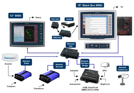
The 8000i has a lot of sizzle, and some interesting new charts, but let’s start coverage with a system overview (bigger here):
* The sunlight viewable multifunction displays are Windows PCs; the 12” is self contained while the 15” is broken into monitor, processor, and keyboard modules. (Both units are also touch screen, but more on that later).
* This is a ‘masterless’ network, meaning that sounder, radar, cameras, and even the various sensor networks go directly to an Ethernet hub. If one PC is shut down, or craps out, it should not affect what the others can do. Several manufacturers have network black box sounders, and a couple have Ethernet radars, but this is the first time I’ve seen network cameras or a Network Interface Bridge (USB, SmartCraft, and NMEA 0183, with—hooray!—NMEA 2000 coming in the fall).
* The only exception to this ‘masterless’ design is that only one processor can be an entertainment server, burning CDs and DVDs with the built in ‘jukebox’ software. But then any display can play from the music and movie library at will, audio going to a nearby stereo and video either playing right on the 8000i screen or on a TV.
* All the parts shown, and the necessary cabling, are supposedly waterproof and marine tough.
Yes, it’s expensive—the 12” retails at $7,000–-but the 8000i looks like a smartly designed system, with a lot of redundancy, power, flexibility, and pizazz built in. More details to come.
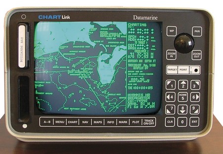
C-Map owns this ‘historic’ machine, which is supposedly the first chart plotter (bigger here) ever sold in the U.S. That was around 1985, when Navionics founders Giuseppe Carnevali and Fosco Bianchetti developed the first crude vector charts and this Datamarine-labeled plotter to show them. (Bianchetti soon went off to found C-Map). Wasn’t it about 5 years later that the first PC charting program came out? At any rate, we’ve come a hell of long ways in 20 years, and Carnevali and Bianchetti—who still run their companies—deserve some of the credit.
Now, would anyone care to predict what marine electronics will look like in another 20 years? 10? 5? With that, I wish you all a wonderful new year.
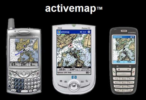
NOAA’s free chart policy strikes again! Maptech will no longer sell Outdoor Navigator, the nifty PDA (both PocketPC and Palm) and Smartphone charting program sort of shown above. The developer, Jeffrey Siegel, has decided to go independent, largely because he can now freely access U.S. raster charts and topo maps. Moreover, the program, to be called activemap, will also be free. I don’t quite understand the business plan, if there is one, but am quite sure that Jeff and his team are up to something interesting. More as available.
You have seen their technology embedded in other guys’ products for years. This New Zealand company produces a wide range of sensors and instruments for your boat. They make great aftermarket installations for boats that were not originally equipped with the sensor you want. Their products range from tank levels, RPM, pressure, etc. The thing that caught my eye was how many devices they offer, all packaged in nice, common format displays. Check them out at www.cruzpro.com. — Jeff Hummel

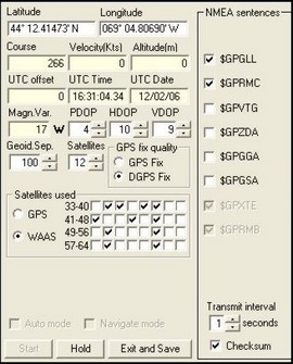 My head hurts! I’ve got 11 ECS packages installed here now, and I’ve been fooling with them on two computers for the last several days. Would you be surprised to hear that Windows XP has occasionally crashed, sometimes violently, and not everything plays together nicely? Like when I start Nobeltec Admiral 8.1, MaxSea 12.2 also tries to start! I have the two computers connected with a null serial cable, meaning I can run