
Remote bottom mapping, who but Lowrance?
Here’s an interesting question: “I am looking for a combo GPS/Sounder for my dinghy, which will record depth data along the GPS track (so we can go out, find the channel, and then bring the dinghy GPS/Sounder to the mother ship and follow the track/depth data).” I can’t think of any truly portable solutions that would work in a rowboat, but I happen to know that this man’s ‘dinghy’ is actually a center console skiff. And that means that any of Lowrance’s recording GPS/fishfinder units, like say a 5” LMS-332C, might do the job. For years now, Lowrance combo units have been able to record your GPS track and sonar imagery to an MMC/SD card (and now to the 20gig hard drives in some units). You can play chart and sonar back on the display itself, split screen like below, or you can put the card in a reader and watch just the sonar scroll on your PC using free viewing software. The picture below (and bigger here) is me trying this feature a few years ago in some skinny Maine waters, and it worked quite well (note: that’s a Navionics Gold chart, not a Lowrance NauticPath). And, by the way, you can also play the recordings back in the nifty PC Product Emulators that Lowrance also gives away. But all this might be overkill in terms of collecting soundings in a poorly charted anchorage. Does anyone know a neat way to collect a depth/position data stream from a small boat, then display it nicely on an electronic chart?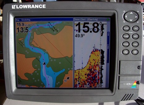
Why not just invest in a Interphase forward looking sonar installed in the "mother ship"? Seems that would provide you with the same information without having to go out exploring with the dinghy.