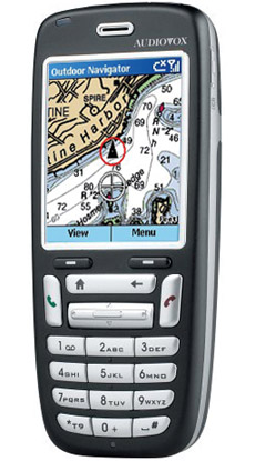
Heck, let’s make this Jeffrey Siegel day at Panbo. You see what I didn’t mention below is that Siegel is also the developer of Maptech’s Outdoor Navigator, an excellent PDA (Palm and PPC) charting program that I wrote about back in early 2002 and which has recently evolved in very interesting ways. I thought it was a pretty good deal at $100 with a year access to all the U.S. charts or topos you wanted to download, but now ON costs a mere $20 and you can keep downloading maps as long as you own the PDA it’s registered to. ON also now works on "Smartphones" using Microsoft's cell operating system. The phones from Audiovox, Motorola, and others do not have touch screens, so all ON's controls have been neatly moved to the keypad. Jeff, who naturally is cruising with all versions of his creation, notes that the lack of a touchscreen is one reason why his smartphone has an extra long battery life. He also notes how useful ON is just as a chart reference tool, no messing with a GPS, especially as Maptech corrects the charts on their servers every month. The whole ON story is here.
This is the first NMEA 0183 multiplexor I know of that can automatically switch to a back up input for any one of three reasons — “a failure to send any NMEA data, an invalid NMEA sentence checksum, or if the validity flag(s) contained within the NMEA sentence indicate that this data is not valid and should only be used with caution (for GPS and Depth data)”. In other words, you could have 4 GPSs (or, more likely 2 GPSs and 2 sounders) feeding the best available data to, say, a plotter and a PC…no manual backup switches needed. Very slick. Actisense’s site has lots of good information on the NSW-1, and it’s available for 260 pounds from at least one English online retailer (the U.S. distributor is Gem Electronics, 843–394–3565).
Writing the entry below I realized that there doesn’t seem to be a picture of the sailboat WeatherStation model on the Web, and there should be! Astute observers will note that a French company, LCJ Capteurs, has offered a CV3F ultrasonic wind sensor for some time. In fact, Airmar licensed this solid-state design, and then reportedly improved it—adding a little heater to protect against extreme ice/snow interference and an inclinometer to correct for heeling errors. The developers at Airmar also threw in a fluxgate compass for true wind direction calculation, and even an LED lit Windex indicator for sailors who like to sometimes look aloft instead of at a screen (and/or like having a non electronic back up). The WeatherStation, which will cost about $1,000, can also sense air temperature, barometric pressure, and more, and can supposedly collect some history on its own. The intriguing device manages to squeeze all this info into one cable and the NMEA 0183 protocol, but a coming NMEA 2000 model will be better at data distribution. No instrument or display manufacturer has yet announced a product that will make the most of this sensor, but no doubt several are working on it. Airmar has not posted any product specs on its site yet, or I couldn’t find it!
“Let us now praise consumer electronics—the iPod, Palm Pilot, the computer and even the not-so-lowly TV set. Why? Because while virtually everything else in yachting becomes more costly, marine electronics consistently provide more value for your money, in large measure due to the use of the billions of dollars invested in consumer product technology.”
That’s how Chuck Husick begins his latest at Yachtingnet, an interesting look at new trends. Chuck’s piece led me to learn more about Organic Light-Emitting Diode (OLED) screens, like the prototype shown. Note that someone at Yachtingnet, probably not Chuck, mistakenly captioned the Airmar WeatherStation as wireless; it’s not, though it’s a fascinating product.
Lowrance started talking about its new NauticPath electronic charts last fall, but the details — cost, which plotters they’ll run on, and “where the heck did Lowrance get them?” — are still resolving themselves. You may still find Web references to regional cards at $99 apiece, but it’s definite now that Lowrance will ship (very soon) all U.S. coastal charts on one card for $109 retail! And a new page at Lowrance says that the Great Lakes, Bahamas, Puerto Rico, and USVI are also included! The same page indicates that most every plotter in Lowrance’s fast-growing line will run these charts, though a firmware upgrade may be needed. So one sweet possibility is backing up a boat’s plotter system with an inexpensive waterproof handheld loaded with charts, and also able to play MP3 music! By the way, at a Miami Boat Show press conference, Lowrance allowed that NauticPath is based on the same Transas chart database that Nobeltec and Garmin licensed as the foundation of their electronic chart formats.
Lowrance has a phenomenal number of new products this year, and the specs on many of them will likely prompt more exclamation points here.
Panasonic calls it a Toughbook MDWD, an awkward acronym for Mobile Data Wireless Display. Nobeltec simplified it to WND for Wireless Nobeltec Display. Whatever the name, this touch screen portable display is nifty technology, able to extend the usefulness of a “down below” PC to most anywhere on deck. Once you’ve added a WiFi transceiver (easy) and the included MDWD/WND drivers to the PC, you can run it remotely with a stylus or even a finger tip. The weather resistant wireless display even comes with a wrist strap. I tested one a couple of years ago and was impressed with how readable the 8.4” screen was, even in difficult light. Now Nobeltec is offering a new MK2 model ($1,900) that is purportedly even brighter, and has a longer battery life. Nobeltec is also now stocking extra battery packs and an AC adapter.
Garmin’s new 192C plotter and 198C plotter/sounder come with full detail BlueCharts for all U.S. coastal waters, including Alaska and Hawaii, loaded in non-volatile memory and ready to use! This is remarkable news because until now you had to also buy either chart cards or a CD with which you burned your own chart card. Either way, getting charts for, say, a trip down the East Coast could cost more than the total $964 price tag on the 192C, and was more hassle. One possible downside of the pre-loaded charts is that you won’t have a card or CD that you can use with a backup plotter. It’s also not clear how Garmin will update these charts, or if they will work via USB for planning on a PC. I look forward to trying one of these five-inch diagonal units, which also boast “a new look and feel”, in the near future.
Garmin’s charts-included strategy, which will likely come to other new models as they roll out (just guessing), is only one of several major changes in the world of electronic charts that I’ll try to touch on here over the next few weeks.
Electronic chart manufacturer C-MAP has obtained ISO 19379 certification for its CM-93/3 and NT-Link electronic chart databases. ISO does not necessarily say anything about the quality of the product itself, but nevertheless it is an important step towards safer boating when using electronic charts.
"The emergence of several privately produced electronic chart databases over the past few years can give the impression to customers that all electronic chart databases are equal,� said Ken Cirillo, vice president and general manager of C-MAP/USA. �But this certification and �seal of approval� from the ISO is a testament of the highest regard to a private electronic chart manufacturer, as it clearly demonstrates the level of quality of a product with this approval."
Still using pen and paper for your ship's log? How about this great tool that will allow you to publish all this information (even in real-time) to a website/weblog...
"GPS Visualizer supports uploaded GPX track and waypoint files, OziExplorer track and waypoint files, Geocaching.com LOC files, IGC log files, Garmin Forerunner Logbook XML files, tab-delimited or comma-separated text files, Cetus GPS and PathAway .pdb files, and NetStumbler log files. You can also enter waypoint data manually, if you just need to plot a few points."
I'm sure these are electronics and software most of you don't have any experience with, but I would not be surprised if they will eventually come available in one way or another to amateur racing or even leisure sailing.
"During training, salient data is taken from various optical-fibre-based devices that measure strain on the boat, as well as various sensors that measure boat speed, wind speed and direction. Fibre optics change their refractive index when put under strain so the strain can be measured by measuring the change in wavelength of the light transmitted. The data is read via a wireless LAN connection into data files, which can then be quickly and easily manipulated in MATLAB on a support boat. The results can be visually displayed in a variety of different ways to help the team make quick decisions about changing the yacht�s set-up."

 Heck, let’s make this Jeffrey Siegel day at Panbo. You see what I didn’t mention below is that Siegel is also the developer of Maptech’s Outdoor Navigator, an excellent PDA (Palm and PPC) charting program that I wrote about back in early 2002 and which has recently evolved in very interesting ways. I thought it was a pretty good deal at $100 with a year access to all the U.S. charts or topos you wanted to download, but now ON costs a mere $20 and you can keep downloading maps as long as you own the PDA it’s registered to. ON also now works on "Smartphones" using Microsoft's cell operating system. The phones from Audiovox, Motorola, and others do not have touch screens, so all ON's controls have been neatly moved to the keypad. Jeff, who naturally is cruising with all versions of his creation, notes that the lack of a touchscreen is one reason why his smartphone has an extra long battery life. He also notes how useful ON is just as a chart reference tool, no messing with a GPS, especially as Maptech corrects the charts on their servers every month. The whole ON story is here.
 This is the first NMEA 0183 multiplexor I know of that can automatically switch to a back up input for any one of three reasons — “a failure to send any NMEA data, an invalid NMEA sentence checksum, or if the validity flag(s) contained within the NMEA sentence indicate that this data is not valid and should only be used with caution (for GPS and Depth data)”. In other words, you could have 4 GPSs (or, more likely 2 GPSs and 2 sounders) feeding the best available data to, say, a plotter and a PC…no manual backup switches needed. Very slick. Actisense’s site has lots of good information on the
 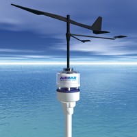 Writing the entry
 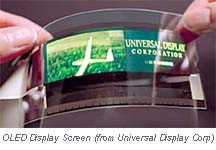 “Let us now praise consumer electronics—the iPod, Palm Pilot, the computer and even the not-so-lowly TV set. Why? Because while virtually everything else in yachting becomes more costly, marine electronics consistently provide more value for your money, in large measure due to the use of the billions of dollars invested in consumer product technology.”
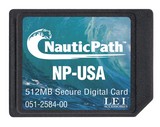 Lowrance started talking about its new NauticPath electronic charts last fall, but the details — cost, which plotters they’ll run on, and “where the heck did Lowrance get them?” — are still resolving themselves. You may still find Web references to regional cards at $99 apiece, but it’s definite now that Lowrance will ship (very soon) all U.S. coastal charts on one card for $109 retail! And a new
 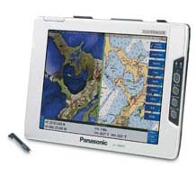 Panasonic calls it a Toughbook
 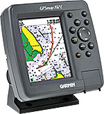 Garmin’s new
  but nevertheless it is an important step towards safer boating when using electronic charts.
 Still using pen and paper for your ship's log? How about
  but I would not be surprised if they will eventually come available in one way or another to amateur racing or even leisure sailing.