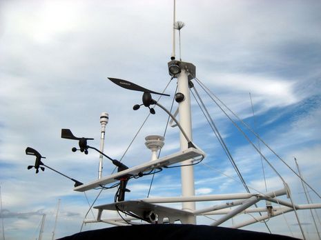
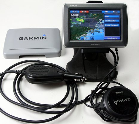
Yes, this rig is raising some eyebrows around Camden Harbor, but I think it will teach me more about NMEA 2000 wind sensors than I've been able to figure out in the lab. I've got all five cabled to the test instrument panel as well as a MFD or two and Gizmo's laptop. And you can see that I can at least theoretically simulate sailboat mast heel and motion thanks to the Ram Mount. I'm not expecting to get wind-tunnel-accurate results here, but it should be interesting. Don't hesitate with suggestions on how to use this rig and what to look for; I should be online much of the day, and may even update this entry from the boat. Good times...
I think that the Google news search above, and those 397 articles you can click through to, mostly indicate that the US General Accounting Office accomplished its goal: Light a fire under the collective butt of the U.S. Air Force, which has apparently been slow at deploying two billion dollars to upgrade the GPS satellite system (GAO report here). I've gotten several notes of concern about the situation, but I think boaters are about the last user group that needs to worry about it. We almost invariably use GPS in almost ideal conditions, puttering along at a relatively slow speed with a wide open sky view. And we don't care beans about altitude (except for going negative)! We were about the first to get into GPS because it was useful on the water before the full constellation of satellites was in place, and, if the system truly does break down, we may be the last. But we surely do value electronic positioning a great deal. So here's my question: If we're having trouble keeping GPS fit on a two billion dollar budget, why the heck is the government even considering saving a tenth of that by shutting down eLoran, a viable backup system?
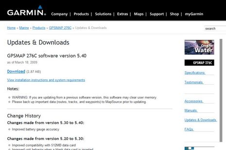
Lucky me, I have an amazingly bright and progressive plumber who is also a seriously addicted boater, and sometimes we barter our respective skills. Which is how I found myself tuning up and updating his old GPSMap 276C last week. I was amazed to discover that Garmin's latest update for it was just released on March 19; it's a minor update, to be sure, but this unit has been around since 2004 (when I gave it a prize). And so I planned an entry complimenting Garmin on its perfectionistic persistence...but that was before I saw the just-released 5.0 software for the networkable 4- and 5000 series. Wow...
I plan to thoroughly check out the sample Lowrance HDS-10 I recently received, and will probably write about it a lot too. It marks not only a major MFD refresh for Lowrance, but also, I'm told, the first MFD series based on NOS, the Navico Operating System. In other words, the underlying software was created not only by Lowrance developers but others in Navico's now global R&D department, and some form of it will likely show up in future products from Navico's other brands, like Simrad and Northstar. I'm going to save the sexy stuff for next week, when I try the unit on the water; today I'm going to mostly discuss some geeky but important data networking aspects of the machine...
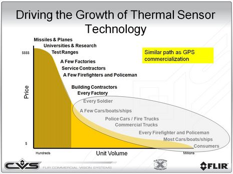
This graph is a thermal sensor manufacturer's dream -- and was, in fact, created by the marketing department at FLIR -- but, hey, that's us way over to the right. I'd love to see the price of thermal cameras go so low, and unit volume so high, that "most cars/boats/ships" have them. Like GPS, once you understand how well the technology works, you want to have it aboard. I remember well the Magellan Nav 1000 (below), which seemed totally magic 20 years ago, but was actually quite crude and cost over $1,000...
One gizmo that's definitely coming along on the Gizmo delivery is this Garmin 640 beta unit. In nüvi mode it can navigate the highways down to Connecticut, as it's done well twice already, and I can then reboot it into marine mode for the voyage home, with XM audio and weather available all the while. The marine satellite weather presentation seems particularly good, as you can see somewhat if you click on the screen above; it's set up so that the Nexrad radar and cloud cover are animated and a finger tap leads to a choice of local forecasts, buoy data, and more, depending where you tap. But finding a good place for this 18 ounce "portable" on your dash or at your helm may not be easy...
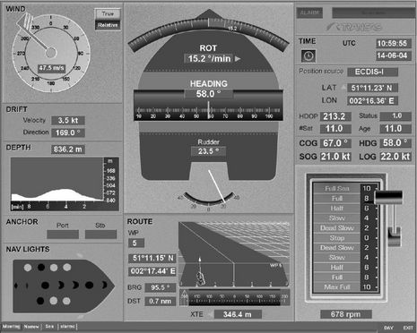
It wasn't just pirate drama (hurray for the good guys!) that had me thinking about big ship helms recently. When I was reading IEC documents about AIS target plotting last week, I came across the nifty "conning display" above. Even in greyscale it suggests how useful it is to integrate lots of usually discrete vessel data onto one screen. While I've seen conning displays in the past, and thought that something similar could be useful on even medium size yachts, that thought is particularly intriquing because nowadays every bit of data on this screen could be delivered over a single NMEA 2000 backbone.
I spent some of this weekend installing and trying out Coastal Explorer 2009, and was thoroughly impressed. CE, also sold as Maptech Chart Navigator Pro, has always been an excellent charting program, in my opinion, and the 2009 edition is a worthy successor. The screen shot above, for instance, shows the slick new automated NOAA raster and vector chart updating routine (and the fact I was doing the updating while riding a train, via a Sprint EVDO WiFi server, suggests how possible online onboard is getting). CE 2009 also easily incorporated lots of Maptech data -- photo maps, topos, harbor photos, and marina databases -- that was already on my PCs. But CE's included Guide Book data, access to TerraServer photo maps and its new abilities to display Panoramio photos and CE user community POI info (photos included) make Maptech data somewhat less important. Which may be a good thing, in a way, as the relationship between CE's creator, Rosepoint Navigation, and the company that took over Maptech's digital chart business, Maptech Navigation, has gotten a little confusing...
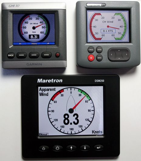
I'm pleased to report that wind speed and direction data from Garmin's GWS 10 NMEA 2000 wind wand shows up fine on all the N2K instrument displays and MFDs in the lab. (There is a small problem with the GWS's air temp and pressure data, which Garmin will probably fix quickly.) The only oddity is a substantial response lag on the Raymarine ST70 (but I understand that a major software update of that unit is coming soon). Using the GMI 10 or a Garmin MFD like the 5212 you can correct the vane's offset (if the masthead install wasn't perfect) or dial in speed and direction dampening factors if you don't like the "auto" modes (I do, so far). Aside from the ST70, all displays responded instantly to such calibrations. While it's nice that sensor/display mixing is possible, Garmin deserves applause for the wind screens it created for the GMI 10. The Garmin coders might consider "borrowing" that rectangular gauge design from Raymarine -- which makes maximum use of the screen -- but Raymarine, and Maretron, ought to "borrow" a lot from Garmin...
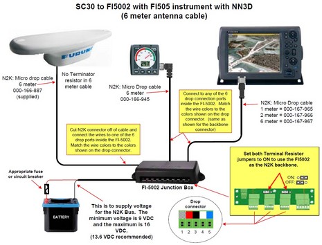
Furuno USA has finally released the SC30 Satellite Compass, after putting it "through strenuous testing" and "modifying the software to meet our testing requirements." Heck, I thought it performed phenomenally well last June. The SC30 is NMEA 2000 device, and an interesting aspect of its launch is Furuno's excellent PDF diagrams illustrating all the ways it can be installed. Today I recommended the Installation Guide in the back of the Maretron catalog as a good reference on N2K wiring, but it does tend to portray 2000 backbones in a more linear way than they really have to be. In the diagram above, for instance, the Furuno FI-50002 junction box is serving as the the entire backbone, power feed and terminators included, and all the other devices are being dropped off (to the 6 meter max). The diagrams also reveal a Furuno translator box developement they haven't talked about yet...